
VIZSLA COPPER INTERSECTS MINERALIZED BRECCIA IN EXPLORATION DRILLING NEAR THE THREE FIRS TARGET, WOODJAM PROJECT
Vizsla Copper Corp. (TSX-V: VCU) (OTCQB: VCUFF) (FRANKFURT: 97E0) is pleased to report final drill results from its summer core drilling program at the Woodjam and Redgold copper-gold projects in central BC (Figure 1).
A polymictic breccia containing intrusive clasts with porphyry-related quartz-chalcopyrite±bornite stockwork was intersected in two drill holes northwest of the Three Firs target. The clasts may suggest proximity to a potentially mineralized and concealed copper-gold porphyry system. Future drilling at Three Firs will target the source of the mineralized clasts.
HIGHLIGHTS
- Drill holes TF24-123 and TF24-126 intersected a new zone of polymictic breccia approximately 500 meters northwest of the Three Firs copper-gold target:
-
- Breccia contains common intrusive clasts with quartz-chalcopyrite±bornite stockwork
- Assays from the breccia returned up to 0.35% copper and 0.50 g/t gold, with mineralization hosted mainly in the clasts
- Results from a recent induced polarization (IP) survey across the Three Firs area demonstrate an increase in chargeability in the down-plunge direction from the breccia intersections
- Future drilling will target the source of the mineralized clasts
- Drill hole DH24-125 targeted the southern extension of the Deerhorn deposit:
-
- 50 meter step-out hole along strike to the south of the Deerhorn deposit intersected strong alteration with individual assays up to 3.5% copper
- 2024 exploration program successfully:
-
- Expanded the Deerhorn copper-gold deposit where mineralization remains open
- Expanded and verified higher-grade copper-gold zones within the Southeast deposit
- Generated high-priority exploration targets at the Great Plains and Three Firs areas
“I’m very pleased with the results of our summer exploration programs,” commented Craig Parry, Executive Chairman. “Woodjam continues to deliver exceptional exploration results, and the mineralized breccia intersections at the Three Firs zone provide further evidence that additional porphyry-related deposits are waiting to be found.”
“Thanks to the excellent work of our field crews, the summer drilling program at Woodjam has been very successful,” commented Steve Blower, Vice President of Exploration. “We’ve expanded zones of high-value mineralization at both the Deerhorn and Southeast deposits, and with the mineralized breccia intersections, we’re possibly vectoring toward a new porphyry center at Three Firs.”
2024 Exploration Program
The 2024 exploration program at the Woodjam and Redgold projects (Figure 1) consisted of over 4,000 metres of diamond drilling in ten holes (seven at Woodjam and three at Redgold) and the completion of over 40 line kilometres of induced polarization (IP) geophysical surveying across three main target areas (Three Firs, Great Plains and Redgold).
The program successfully accomplished its two main objectives: 1) expand on high-grade porphyry-related gold-copper mineralization at the Deerhorn and Southeast deposits (see September 3rd, 2024 and September 9th, 2024 news releases), and 2) define new exploration targets to be evaluated in future drill programs (Three Firs, this release and Great Plains, see October 30th, 2024 news release).
Three Firs
Drilling at Three Firs was designed to investigate the extent of near-surface, porphyry-related copper and gold mineralization to the northwest. Drill holes TF24-123 and TF24-126, collared 500 meters from the core of the Three Firs target (Figure 2), intersected a new occurrence of polymictic breccia containing intrusive clasts with porphyry-related quartz-chalcopyrite±bornite stockwork (Figures 4 and 5).
Mineralized clast-bearing breccia was intersected over 41.6 meters (363.4 m to 405 m at EOH) in TF24-123 and in TF24-126 over two intervals including 27.6 meters (499.7 m to 527.3 m, upper breccia) and 39.9 meters (598.15 m to 638.0 m, lower breccia). Based on clast composition and texture, the breccia in TF24-123 is interpreted to be related to the upper breccia in TF24-126. The breccia matrix in TF24-123 has been strongly clay+carbonate altered (Figure 4) whereas the matrix in the upper breccia in TF24-126 is variably quartz-sericite-chlorite altered (Figure 5d). In both intervals, clast compositions vary from intrusive (monzonite to granodiorite) with porphyry-related stockwork, fractured and truncated quartz veins, to plagioclase porphyritic andesites, hornblende-phyric diorites, and fine-grained volcanics/sediments (Figures 4b, c, d, e and 5b, c, d). Potassically altered intrusive clasts are more abundant in TF24-126 and clasts with porphyry-related stockwork mineralization are locally brecciated (Figures 4b, d). The frequency of mineralized clasts within the TF24-123 and upper TF24-26 breccias increases with depth from hole TF24-123 to TF24-126 corresponding to an increase in copper and gold grades. The breccia in TF24-126 returned 27.6 meters of 0.18% copper and 0.13 g/t gold relative to TF24-123 which yielded 41.6 meters of 0.06% copper and 0.03 g/t gold (Table 1 and Figure 3). The lower breccia in TF24-126 (Figure 6) contains strongly sericite altered andesite clasts set in a quartz-pyrite cement. Minor chalcopyrite-bearing clasts are also observed (Figure 6b).
The presence of multiple facies of polymictic breccias in TF24-123 and TF24-126 suggests a complex magmatic-hydrothermal system during the late-stages of porphyry system development in the Three Firs area. Modelling shows a general plunge of the breccia system to the southeast towards a broad and untested high-chargeability anomaly (Figure 3). This anomaly will be tested for a potential center of intrusion-hosted, porphyry-related mineralization and the source of the mineralized clasts within the breccias.
Deerhorn Expansion Drilling
Drill hole DH24-125 at the Deerhorn deposit was designed to step-out 50 meters south of the previously reported drill hole DH24-120, which intersected 1.16 g/t gold equivalent (0.91 g/t gold, 0.18% copper) over 86.0m (see September 3rd, 2024 news release, Table 1). DH24-125 intersected a broad zone of strong fracturing with associated clay alteration and local copper and gold mineralization, up to 3.5% copper and 0.6 g/t gold (Figure 7). Further drilling up-dip from holes DH24-120 and DH24-125 is required to evaluate the extension of mineralization southeast from the main Deerhorn resource area.
Redgold Inaugural Drilling
Drilling at the Redgold project, contiguous and immediately north of the Woodjam district (Figure 1), consisted of three holes, targeting the eastern and northern extension of porphyry-related copper and gold mineralization at the East zone target (Figure 8). Hole RG24-15, a 135 meter step-out to the southeast of hole RG12-11 (151.9 meters of 0.21% copper with 0.24 g/t gold3, see May 12th, 2023 news release), intersected numerous intervals of anomalous copper and gold mineralization highlighted by 30.0 meters of 0.15% copper and 0.13 g/t gold. These new drill results together with recently acquired IP chargeability and resistivity data will be interpreted together to refine the Redgold exploration model.
Next Steps
The 2024 drill program is now complete and assay results have been received from all the drill holes. New drilling and geophysical data are currently being integrated with existing project-wide data to prioritize targets for the next phase of exploration which may include drilling at the Three Firs, Deerhorn, and Southeast targets.
Table 1. Woodjam and Redgold 2024 Assay Summary
| Area | Hole-ID | Significant Intersections2 | ||||
| From (m) |
To (m) | Length (m) | Cu (%) | Au (g/t) | ||
| Deerhorn | DH24-1191 | Abandoned Before Target | ||||
| Deerhorn | DH24-1201 | 191.0 | 277.0 | 86.0 | 0.18 | 0.91 |
| includes | 208.5 | 277.0 | 68.5 | 0.18 | 1.07 | |
| Deerhorn | DH24-1253 | 232.0 | 238.0 | 6.0 | 0.27 | 0.41 |
| and | 287.0 | 303.6 | 16.6 | 0.18 | 0.08 | |
| includes | 287.0 | 293.0 | 6.0 | 0.35 | 0.14 | |
| Southeast | SE24-1211 | 63.1 | 273.3 | 210.2 | 0.35 | 0.09 |
| includes | 63.1 | 114.7 | 51.6 | 0.52 | 0.16 | |
| Southeast | SE24-1221 | 65.0 | 242.3 | 177.3 | 0.56 | 0.29 |
| includes | 65.0 | 160.0 | 95.0 | 0.75 | 0.46 | |
| Three Firs | TF24-1234 | 363.4 | 405.0 | 41.6 | 0.06 | 0.03 |
| Three Firs | TF24-124 | No significant Intersections | ||||
| Three Firs | TF24-1263 | 499.7 | 527.3 | 27.6 | 0.18 | 0.13 |
| includes | 515.0 | 527.3 | 12.3 | 0.20 | 0.25 | |
| Redgold | RG24-153 | 79.0 | 109.0 | 30.0 | 0.13 | 0.15 |
| and | 131.0 | 133.8 | 2.8 | 0.65 | 0.10 | |
| and | 179.0 | 186.0 | 7.0 | 0.20 | 0.35 | |
| and | 275.0 | 293.0 | 18.0 | 0.09 | 0.11 | |
| Redgold | RG24-16 | No significant Intersections | ||||
| Redgold | RG24-17 | No significant Intersections | ||||
|
Notes: |
||||||
| 1. | Previously disclosed, see September 3rd, 2024 and September 9th, 2024 news releases | |||||
| 2. | Intervals are downhole core lengths. True widths are unknown. | |||||
| 3. | Calculations are length-weighted using a 0.10 g/t Au or 0.10% Cu cutoff | |||||
| 4. | No cutoff applied to length-weighted interval | |||||
Table 2. Drill Collar Information
| Hole ID | Project | Easting* | Northing* | Elevation (m) |
Azimuth | Dip |
| DH24-119 | Woodjam | 611185 | 5791908 | 918 | 128.0 | -45.0 |
| DH24-120 | Woodjam | 611467 | 5791738 | 920 | 228.4 | -59.5 |
| DH24-125 | Woodjam | 611458 | 5791672 | 915 | 215.5 | -73.0 |
| SE24-121 | Woodjam | 612967 | 5787807 | 1013 | 221.6 | -60.2 |
| SE24-122 | Woodjam | 612979 | 5787878 | 1015 | 305.6 | -79.8 |
| TF24-123 | Woodjam | 608470 | 5787687 | 977 | 221.6 | -60.2 |
| TF24-124 | Woodjam | 608448 | 5787451 | 979 | 222.3 | -59.8 |
| TF24-126 | Woodjam | 608470 | 5787687 | 977 | 200.0 | -67.0 |
| RG24-15 | Redgold | 604627 | 5813663 | 966 | 65.0 | -60.0 |
| RG24-16 | Redgold | 604782 | 5813743 | 936 | 63.4 | -60.0 |
| RG24-17 | Redgold | 604691 | 5814321 | 906 | 63.5 | -60.4 |
| *UTM NAD 83 Zone 10 |
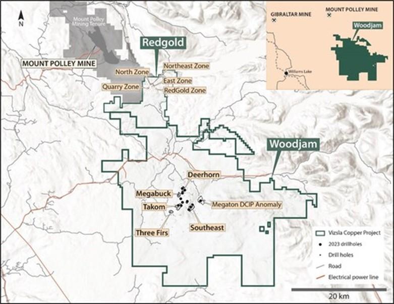
Figure 1. Map of the Woodjam and Redgold projects.
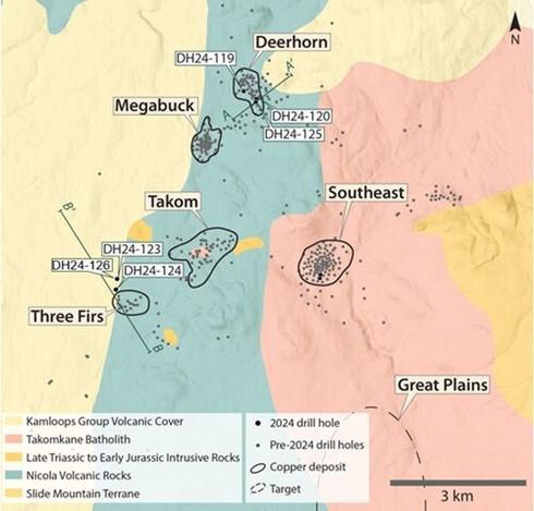
Figure 2. Map showing the main target areas on the Woodjam project and the location of 2024 drill holes.
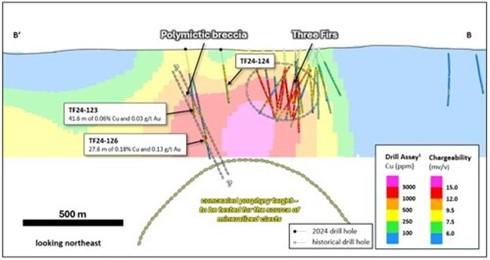
Figure 3. Schematic section across the Three Firs area showing the locations of exploration holes TF24-123, TF24-24 and TF24-126 in relation to historical drilling1 and a section through the inverted chargeability model. The zone of polymictic breccia is modeled with a SE plunge highlighting a potential target at depth below the Three Firs area. Intervals are downhole length-weighted. True widths are unknown.
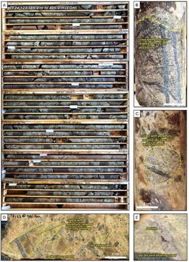
Figure 4. Core photos of TF24-123. A. Box photos showing core from 389.4 to 405.0 meters (EOH) downhole. Zones of bleaching in the matrix caused by clay + carbonate alteration. Larger subrounded purple clasts are plagioclase-phyric andesite, B and C. Examples of rounded intrusive clasts with porphyry-related mineralization (quartz-chalcopyrite-bornite stockwork). D. Polymictic breccia near the bottom of the drill hole with mineralized and quartz vein clasts set in a clay + carbonate cement. E. Example of quartz vein with bornite cutting porphyry clast. Abbreviations: qtz = quartz, cpy = chalcopyrite, bn = bornite, carb = carbonate.
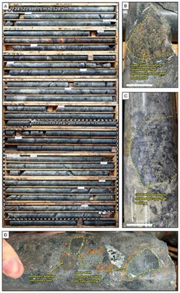
Figure 5. Core photos of the upper breccia zone in TF24-126. A. Box photos showing core from 499.75 to 528.2 meters downhole. An increase in mineralized clasts at 515.0 meters resulted in a 12.3 meter interval of 0.25 g/t gold with 0.20% copper. B. Example of brecciated and potassically altered intrusive clast with fine quartz-chalcopyrite-magnetite stockwork. C. Mineralized clast with quartz-chalcopyrite-magnetite vein. D. Polymictic breccia showing mineralized clasts, potassically altered intrusive clasts, hornblende-phyric diorite clasts, and plagioclase-phyric andesite clasts set in a fine-grained magmatic(?) matrix. Abbreviations: qtz = quartz, cpy = chalcopyrite, mgt = magnetite
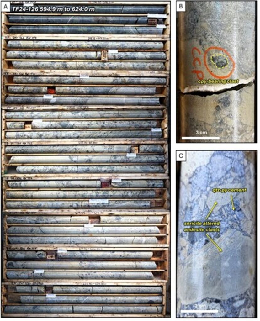
Figure 6. Core photos of the lower breccia zone in TF24-126. A. Box photos showing core from 594.9 to 624.0 meters downhole. Sharp contact with Nicola group volcanics at 598.15 meters. The bleaching of many of the clasts is caused by sericite (white mica) alteration. B. Local chalcopyrite bearing clast in quartz-pyrite cemented breccia. C. Sericite-altered clasts set in a quartz-pyrite hydrothermal cement. Abbreviations: qtz = quartz, py = pyrite, cpy = chalcopyrite.
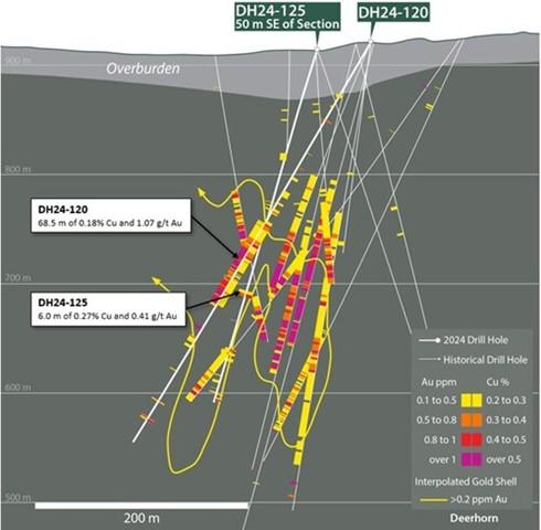
Figure 7. Southwest-northeast section across the southeastern extent of the Deerhorn deposit showing the location of DH24-125 and DH24-120 (previously released). Interpolated gold shell is based on preliminary modelling of current and historical assay data2 and is shown to schematically show the distribution of porphyry-related gold mineralization. Copper results (right side of drill trace) only shown for 2024 holes. Intervals are downhole length-weighted. True widths are unknown. Section width is 90 m.
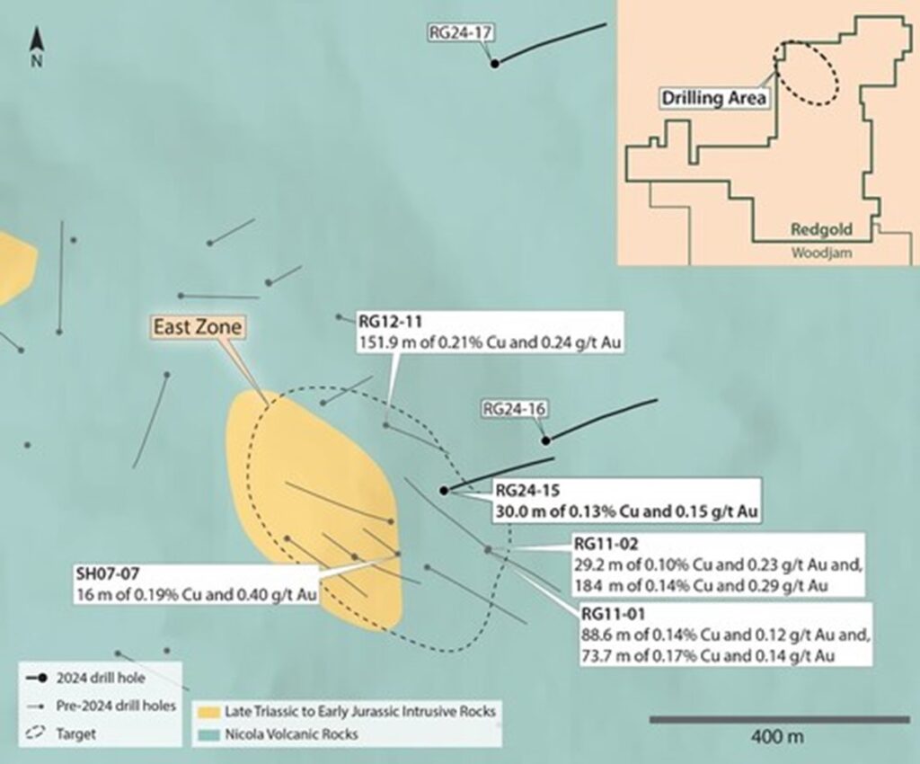
Figure 8. Map of the Redgold Project showing the location of the 2024 drill holes with select historical drill results3. Intervals are downhole length-weighted. True widths are unknown.
Sampling, Chain of Custody, Quality Assurance and Quality Control
All drill core analytical results have been monitored through the Company’s quality assurance and quality control program. Drill core was sawn in half at Vizsla’s dedicated and secure core logging and processing facility in Horsefly, BC.
Half of the drill core was sampled and shipped by a bonded courier in sealed and secured woven polyester bags to the ALS Global preparation facilities in Kamloops, BC. Core samples were prepared using ALS standard preparation procedure PREP-31A which involves crushing the sample to 70% less than 2mm, followed by a riffle split of 250g, and then a pulverised split to better than 85% passing 75 microns.
Following sample preparation, the pulps were sent to the ALS Global analytical laboratory in North Vancouver, BC for analysis. ALS Global is registered to ISO/IEC 17025:2017 accreditations for laboratory procedures.
Drill core samples were analyzed for 48 elements by ICP-MS on a 0.25-gram aliquot using a four-acid digestion (method ME-MS61). Overlimit samples (>10,000 ppm Cu) were re-analyzed using an ore-grade, four-acid digestion and ICP-AES finish (method ME-OG62). Gold was analyzed by fire assay on a 30-gram aliquot with an AES finish (inductively coupled plasma atomic emission spectroscopy – method Au-ICP21).
In addition to ALS Global laboratory QA/QC protocols, Vizsla implements a rigorous internal QA/QC program that includes the insertion of field and lab duplicates, certified reference materials (standards prepared by an independent lab) and blanks into the sample stream. Data verification of the analytical results includes a statistical analysis of the QA/QC data. Results are considered acceptable.
About Vizsla Copper
Vizsla Copper is a Cu-Au-Mo focused mineral exploration and development company headquartered in Vancouver, Canada. The Company is primarily focused on its flagship Woodjam project, located within the prolific Quesnel Terrane, 55 kilometers east of the community of Williams Lake, British Columbia. It has three additional copper properties: Poplar, Copperview, and Redgold, all well situated amongst significant infrastructure in British Columbia. The Company’s growth strategy is focused on the exploration and development of its copper properties within its portfolio in addition to value accretive acquisitions. Vizsla Copper’s vision is to be a responsible copper explorer and developer in the stable mining jurisdiction of British Columbia, Canada and it is committed to socially responsible exploration and development, working safely, ethically and with integrity.
Vizsla Copper is a spin-out of Vizsla Silver (TSX-V: VZLA) (NYSE: VZLA) and is backed by Inventa Capital Corp., a premier investment group founded in 2017 with the goal of discovering and funding opportunities in the resource sector. Additional information about the Company is available on SEDAR+ (www.sedarplus.ca) and the Company’s website (www.vizslacopper.com).
Qualified Person
The Company’s disclosure of technical or scientific information in this press release has been reviewed and approved by Christopher Leslie, Ph.D., P.Geo., Technical Advisor for Vizsla Copper. Dr. Leslie is a Qualified Person as defined under the terms of National Instrument 43-101.
Some technical information contained in this release is historical in nature and has been compiled from public sources believed to be accurate. The historical technical information has not been verified by Vizsla Copper and may in some instances be unverifiable. Mineralization hosted on adjacent and/or nearby projects is not necessarily indicative of mineralization hosted on Vizsla’s projects.
References
- Summarized in: Blackwell, J., Rainbow, A., and Madsen, J. (2013), 2012 Assessment report on the Woodjam North Property, Including diamond drilling, geochemical sampling and ground magnetics, Cariboo Mining Division, British Columbia, Assessment Report Indexing System, Report 33805, https://apps.nrs.gov.bc.ca/pub/aris
- Summarized in: Lomas, S. (2022), NI43-101 Technical Report for the Woodjam Property Horsefly, British Columbia, Canada, https://sedarplus.ca
- Reported in: Lesage, G. (2013), 2011 Assessment report Redgold Property including soil sampling, surface rock sampling, ground magnetics and diamond drilling, Cariboo Mining Division, Assessment Report Indexing System, Report 32975, https://apps.nrs.gov.bc.ca/pub/aris
MORE or "UNCATEGORIZED"
Delta Reports New Gold Intercept at Nova Target in Wedge Area, 4 Kilometres West of Eureka; Follow-Up Drill Program Underway
Delta Reports New Gold Intercept at Nova Target in Wedge Area, 4 ... READ MORE
Silver One Announces Closing Of Final Tranche Of $32 Million Financing
Silver One Resources Inc. (TSX-V: SVE) (OTCQX: SLVRF) (FSE: BRK1)... READ MORE
SAGA Metals Achieves 100% Drilling Success in 2025—Reports Final Assays from Trapper South at Radar Critical Minerals Project in Labrador
Exceptional grades of Titanium, Vanadium and Iron in all 15 drill... READ MORE
Near Surface Intersection Yields 6.58 g/t gold over 10.35 metres
Intersection is within 33 metres from surface and contained in a ... READ MORE
Alamos Gold Provides Three-Year Operating Guidance Outlining 46% Production Growth by 2028 at Significantly Lower Costs
Further production growth to one million ounces annually expected... READ MORE


