








AMELIA GOLD PROJECT
Ximen Mining Corp. (TSX-V: XIM) (FRA: 1XMA) (OTCQB: XXMMF) announces an initial interpretation of results from an airborne magnetic survey has been completed for its Amelia property, located at historic Gold Camp McKinney near Rock Creek in southern British Columbia.
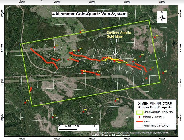
Figure 1. Amelia Property map showing survey area
The Amelia property covers the historic Cariboo-Amelia gold mine in Camp McKinney near Rock Creek, BC in the Greenwood Mining Division. Over its history, the Cariboo Amelia mine produced 81,602 ounces of gold and 32,439 ounces of silver from 112,254 tonnes milled (BC Minfile). The mine is part of a 4 kilometer system of gold-quartz veins and historic workings. Ximen is exploring for extensions to the historic mine and to discover new parallel mineralized zones.
A drone UAV magnetic survey was completed over the core part of Ximen’s Amelia property (Figure 1 above). The survey was flown at a height of 35 m on lines oriented at azimuth 80° and spaced 50 m, for a total of 127.92 line km. The purpose of the survey was to aid interpretation of the geological units beneath cover, and to identify de magnetized areas potentially associated with alteration and mineralization.

Figure 2. Drone Magnetic survey map (total magnetic intensity – reduced to pole) and features identified
Several magnetic anomalies (high and low) were identified in the survey. The western area shows a higher magnetic signature in the TMI-RTP map ( Figure 2 above), that is interpreted as a Jurassic granodioritic intrusion, which has been mapped in the western area of the project. The magnetic high indicates it extends further east than mapped. Two other magnetic highs were identified towards the central-northern area as well as one in the northeast that are interpreted as possible intrusive bodies.
Magnetic lows were identified in the central area as well as in the northeast (2). The stratigraphy of the central and eastern area consists of Paleozoic (Anarchist Schist) comprised of interlayered quartzite and metavolcanic units, and a limestone unit. The magnetic lows possibly represent areas where non-magnetic quartzites are predominant.

Figure 3. Image of the drone magnetic survey (1st vertical derivative) showing lineaments and targets identified
Lineaments were identified using the 1st vertical derivative map (Figure 3 above). The lineaments were separated in high and low magnetic lineaments. The high magnetic lineaments are interpreted as either highly magnetic layers within the interlayered Anarchist Schist unit or magnetic dikes and intrusions. The low magnetic lineaments are interpreted either as faults, lesser magnetic units within the interlayered quartzite, metavolcanic, and limestone package, or known and previously mined quartz veins.
The known mineralized veins at Amelia show a moderate correlation with low magnetic lineaments. In the southwestern area that is dominated by magnetic highs, a prominent low magnetic lineament coincides with the Anarchist vein that is hosted within granodiorite. This magnetic low may correspond to hydrothermally altered granodiorite associated with the quartz vein.
New exploration target areas were selected based on the correlation of magnetic low lineaments with quartz veins (Figure 3 above). They include two located north of the Anarchist vein, two west of the Eureka and Gold Hill veins, one that is the southern extension of the Fontenoy vein, and one that is located southwest of the Fontenoy vein.
Readers are cautioned that historical records referred to in this News Release have been examined but not verified by a Qualified Person. Further work is required to verify that historical records referred to in this News Release are accurate.
Dr. Mathew Ball, P.Geo., VP Exploration for Ximen Mining Corp. and a Qualified Person as defined by NI 43-101, approved the technical information contained in this News Release.
Fredonia Mining Inc. (TSX-V: FRED) is pleased to announce that it has closed its previously announce... READ MORE
SAGA Metals Corp. (TSX-V: SAGA) (OTCQX: SAGMF) (FSE: 20H), a North American exploration company foc... READ MORE
Legacy Gold Mines Ltd. (TSX-V: LEGY) is pleased to report assay results from core holes LG26-017 an... READ MORE
Inventus Mining Corp. (TSX-V: IVS) is pleased to report results from 100 drill holes from its now-... READ MORE
Abcourt Mines Inc. (TSX-V: ABI) (OTCQB: ABMBF) is pleased to present its operational report for the ... READ MORE


