


CRANBROOK BC
Ximen Mining Corp. (TSX-V: XIM) (FRA: 1XMA) (OTCQB: XXMMF) announces that it has initiated a drill program at its Wild Horse Gold project near Cranbrook in southeastern BC.
The Wild Horse project covers source areas for the famous historic Wild Horse River placer gold deposit near Fort Steele and Cranbrook, in southeastern B.C. Bedrock gold was first discovered in this area as early as 1895 but an economic deposit has yet to be defined. Gold-bearing quartz veins and breccias were drilled in 2016 and 2021, on Ximen’s Lone 4 claim, where there is potential for a bulk-minable gold deposit.

Gold (ppb) in soil samples from 2009 Boulder Grid (Report 30952)
This year, Ximen will drill test an area to the northeast on its Boulder Claim, where a 700 x 300 meter gold in soil anomaly was previously identified (BC Assessment report 30952).
The drill will also test beneath an area of abundant boulders of syenite observed on the soil grid. In 2009 it was reported that four boulders of this syenite float were sampled, of which “three were anomalous in gold and one ran 4.1 grams of gold per ton” (Assessment report 34920). The syenite is believed to be part of the mid-Cretaceous felsic intrusive Bayonne plutonic suite that is spatially and possibly genetically related to gold mineralization in the Kimberley Gold Trend.
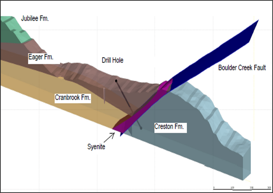
Cross section of 3D model of Boulder Creek drill target (azimuth 056 degrees)
The area is transected by the Boulder Creek fault, a regional high-angle reverse fault that dips 60° to 65° to the northwest and is interpreted as an eastward continuation of the St. Mary fault (BC Geology Survey Bulletin 84). These faults are dominant structures associated with gold deposits in the Kimberley Gold Trend (Geoscience BC Map: 2015-13-01). The St. Mary-Boulder Creek structure is a major transverse fault system that is interpreted as a surface expression the Vulcan Low, a fundamental Precambrian basement transverse structure (McMechan, 2012; Canadian Journal of Earth Sciences, 2012 Vol. 49, p693). This provides a most favourable lithospheric architecture for controlling the location of gold deposits in terms of mineral systems modeling.
Readers are cautioned that historical records referred to in this News Release have been examined but not verified by a Qualified Person. Further work is required to verify that historical records referred to in this News Release are accurate.
Dr. Mathew Ball, P.Geo., VP Exploration for Ximen Mining Corp. and a Qualified Person as defined by NI 43-101, approved the technical information contained in this News Release.
Boreal Gold Inc. (CSE: BGLD) is pleased to announce 15.54 g/t over 2.... READ MORE
Purepoint Uranium Group Inc. (TSX-V: PTU) (OTCQB: PTUUF) reported... READ MORE
Grizzly Discoveries Inc. (TSX-V: GZD) (FSE: G6H) (OTCQB: GZDIF) i... READ MORE
Hole SH26-27 identifies approximately 15 metres (core length) of ... READ MORE
Critical Metals Mineralization Includes 2.40% Cu, 0.83% Ni and 0.... READ MORE


