


Blackrock Silver Corp. (TSX-V: BRC) is pleased to announce drill results from the Company’s ongoing step-out and in-fill drilling programs on its 100% controlled Tonopah West project located in West Central Nevada along the Walker Lane trend.
These results demonstrate continued expansion of the key known mineralized structure on the project, the Denver vein system (also known as “Victor”), by an additional 600 metres to the Northwest, which has now grown to over 3 kilometres of drill-defined strike, and is projected to remain open to the west. In addition, assays have encountered a substantial new zone of mineralization to the south, including our highest-grade and shallowest intercept at the project to date.
Highlights:
Andrew Pollard, Blackrock’s President and CEO, stated, “With two drill rigs at site, the latest assays from our ongoing 25,000 metre programme have materially expanded the footprint of known mineralization at the project, both to the northwest and to the south, delivering what is our highest-grade and shallowest intercept to date for the project in a new and quickly developing target area. The Denver vein system, which includes Victor, continues to show significant resource expansion potential, as step-out drilling has now tracked it an additional 1.6 kilometres to the northwest beyond the DPB resource area, with a further 500 metre step-out planned as part of this programme. Our exploration model, of which continues to be validated, indicates that this structure remains wide open to the west, where we have an additional 1600 metres of strike potential to our consolidated Tonopah property boundary. It’s clear that the project also has very deep roots and it remains open at depth as we’ve yet to find the bottom of the mineralized system.”
Table 1: Significant Tonopah West drillhole assays using a 150 g/t AgEq cut off
| Hole ID | Area | From (m) | To (m) | Length (m) | Gold (gpt) | Silver (gpt) | AgEq (gpt) |
| TW22-118 | NW Step Out | 428.25 | 429.77 | 1.52 | 1.700 | 0.1 | 170.1 |
| TXC22-051 | NW Step Out | NSV | |||||
| TXC22-052 | NW Step Out | 583.94 | 588.54 | 4.60 | 0.627 | 148.1 | 210.9 |
| Including | 584.61 | 585.28 | 0.67 | 1.890 | 513.0 | 702.0 | |
| TXC22-052 | NW Step Out | 592.38 | 594.64 | 2.26 | 0.325 | 132.3 | 164.8 |
| TXC22-053 | NW Step Out | 674.52 | 676.05 | 1.52 | 1.610 | 3.4 | 164.4 |
| TXC22-054 | DPB | 440.13 | 440.44 | 0.31 | 1.810 | 127.0 | 308.0 |
| TXC22-055 | NW Step Out | NSV | |||||
| TXC22-056 | New Discovery | NSV | |||||
| TXC22-057 | New Discovery | 191.42 | 192.94 | 1.52 | 22.881 | 1654.1 | 3942.2 |
| Including | 192.02 | 192.94 | 0.91 | 37.867 | 2740.0 | 6526.7 | |
| TXC22-058 | New Discovery | 220.07 | 221.29 | 1.22 | 1.650 | 10.2 | 175.2 |
| TXC22-059 | New Discovery | 237.44 | 239.94 | 2.50 | 0.755 | 83.6 | 159.1 |
| TXC22-060 | New Discovery | 225.28 | 225.89 | 0.61 | 0.869 | 75.0 | 161.9 |
| AgEq_g/t = Ag_g/t + Au_g/t*100; AuEq_g/t = Au_g/t + Ag_g/t/100. True thickness unknown. NSV = No significant values | |||||||
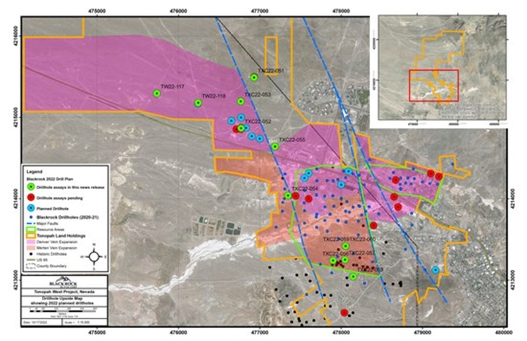
Figure 1: Tonopah West drillhole location map showing the location of drillholes mentioned in this news release (green dots)
Northwest Step Out Target
Drillholes TXC22-051 through -053 and TXC22-055 were completed in the Northwest Step Out target area. Drillhole TXC22-052 is 1,000 metres northwest of the DPB resource area and returned 4.6 metres grading 211 g/t AgEq beneath the Mizpah Andesite.
Data compilation in the Northwest Step Out target shows that drillhole TW22-118 encountered a mineralized structure and returned 170 g/t AgEq over 1.52 metres within the Mizpah Andesite; however, the drillhole terminated above the projected pay zone. TW22-118 is an additional 600 metres west of TXC22-052. Drillhole TW22-117 is 500 metres west of TW22-118. The drillhole encountered the Mizpah Andesite, but was called at 762 metres; thus not testing the mineralized structure beneath the Mizpah.
TXC22-055 was drilled to test the vein structure beneath the Mizpah andesite; however, the drillhole encountered a fault which off set the vein farther to the north. No significant assays were returned, but a better understanding of the cross structure was obtained from the drill information which will help to guide future drilling.
Blackrock’s property boundary extends an additional 1,600 metres west of TW22-117. From the DPB resource area to the edge of the Company’s property boundary, drilling suggests major potential along a 3,700-metre corridor immediately beneath the Mizpah Andesite. The vein system is in a similar stratigraphic position as the Denver vein drilled in the Victor and DPB resource areas. The known strike of the Denver is 1,300 metres drilled in the Victor (500 m) and DPB (800m) resource areas. The Northwest Step shows an additional 3,700 metres of potential along the Denver vein system bringing the total to 5,000 metres of potential high-grade silver and gold on the Tonopah West project (See figure 1). Assay are pending from two core holes, and an additional five pre-collars are complete awaiting core tails.
New Discovery Target
Drilling in the New Discovery target was designed to follow up on Coeur Mining’s 2018 drilling where drillhole TW18-004 encountered a 4.5 metre zone grading 4.933 g/t Au, 337 g/t Ag or 830 g/t AgEq.
Core holes TXC22-056, -057, -058, -059 and TXC22-060 were completed in the target area. Core hole TXC22-057 returned one of the highest grade gold and silver intercepts from the project with over one ounce of gold (37.8 g/t Au) and 2.7 kilograms of silver reported over a 0.91 metre interval. Drillholes TXC22-058, -59 and TXC22-060 all returned significant precious metal assays from the target. Expansion potential is evident, and additional drilling is highly warranted.
Victor Target
Five core holes were completed in the Victor target to test down-dip extensions and footwall vein structures. The drillholes encountered vein material and all assays are currently pending.
DPB Target
Four core drillholes are complete in the DPB area and an additional four are awaiting core tails. Core hole TXC22-054 was drilled to test step-out mineralization encountered in previous drilling (TW21-110). The core hole crossed a north-northwest fault which is believed to be the same structure encountered in TXC22-055. The fault appears to offset mineralization to the north on the west side of the fault. Based on the interpretation of the faults. The DPB area appears to be within a graben bounded on the east and west by north-northwest oriented faults.
The Company is using this new information to help guide continuing exploration of the Tonopah West property and the Tonopah district.
Table 2: Location information for drillholes reported in this new release
| Hole ID | UTM11 NAD27 East | UTM11 NAD27 North | Elevation (m) | Total Depth (m) | Azimuth | Inclination |
| TW22-117 | 475734.9 | 4215296.0 | 1710.9 | 762.0 | 0 | -90 |
| TW22-118 | 476242.1 | 4215180.1 | 1726.0 | 641.6 | 0 | -90 |
| TXC22-051 | 476929.7 | 4215492.2 | 1758.1 | 1212.5 | 180 | -90 |
| TXC22-052 | 476769.5 | 4214867.8 | 1743.4 | 695.9 | 180 | -80 |
| TXC22-053 | 476765.2 | 4215197.7 | 1744.1 | 852.8 | 180 | -80 |
| TXC22-054 | 477345.6 | 4214041.4 | 1759.3 | 599.8 | 180 | -55 |
| TXC22-055 | 477188.0 | 4214642.8 | 1756.7 | 788.8 | 180 | -75 |
| TXC22-056 | 477900.1 | 4213241.9 | 1776.4 | 351.4 | 180 | -70 |
| TXC22-057 | 478047.4 | 4213253.0 | 1786.3 | 296.0 | 180 | -70 |
| TXC22-058 | 478148.2 | 4213045.0 | 1790.9 | 338.9 | 180 | -70 |
| TXC22-059 | 478053.7 | 4213420.3 | 1777.0 | 319.1 | 180 | -80 |
| TXC22-060 | 478053.6 | 4213419.7 | 1777.0 | 299.6 | 180 | -65 |
Quality Assurance/ Quality Control
All sampling is conducted under the supervision of the Company’s project geologists, and a strict chain of custody from the project to the sample preparation facility is implemented and monitored. The reverse circulation samples are hauled from the project site to a secure and fenced facility in Tonopah, Nevada, where they are loaded on to American Assay Laboratory’s (AAL) flat-bed truck and delivered to AAL’s facility in Sparks, Nevada. A sample submittal sheet is delivered to AAL personnel who organize and process the sample intervals pursuant to the Company’s instructions.
The reverse circulation, and QA/QC samples are crushed and pulverized, then the pulverized material is digested and analyzed for Au using fire assay fusion and an Induced Coupled Plasma (ICP) finish on a 30-gram assay split. Silver is determined using five-acid digestion and ICP analysis. Over limits for gold and silver are determined using a gravimetric finish. Data verification of the assay and analytical results are completed to ensure accurate and verifiable results. Blackrock personnel insert a blind prep blank, lab blank or a certified standard approximately every 15th to 20th sample.
Blackrock’s exploration activities at the Tonopah North and Tonopah West projects are conducted and supervised by Mr. William Howald, Executive Chairman of Blackrock. Mr. William Howald, AIPG Certified Professional Geologist #11041, is a Qualified Person as defined under National Instrument 43-101. He has reviewed and approved the contents of this news release.
About Blackrock Silver Corp.
Blackrock is a junior precious metals focused exploration company that is on a quest to make an economic discovery. Anchored by a seasoned Board, the Company is focused on its Nevada portfolio of properties consisting of low-sulphidation epithermal gold & silver projects located along the established Northern Nevada Rift in north-central Nevada and the Walker Lane trend in western Nevada.
First Phosphate Corp. (CSE: PHOS) (OTCQX: FRSPF) (OTCQX ADR: FPH... READ MORE
Highlights: Hole NO-26-21a returned 11.37 m grading 4.92 g/t gold... READ MORE
Guanajuato Silver Company Ltd. (TSX-V:GSVR) (OTCQX:GSVRF) is pl... READ MORE
Falco Resources Ltd. (TSX-V:FPC) is pleased to announce the resul... READ MORE
TDG Gold Corp. (TSX-V: TDG) (OTCQX: TDGGF) is pleased to provide ... READ MORE


