








Thunder Gold Corp. (TSX-V: TGOL) (FSE: Z25) (OTCQB: TGOLF) is pleased to announce the following exploration and infill diamond drill results from the Company’s flagship Tower Mountain Property, 40 kilometres west of Thunder Bay, Ontario.
Highlights:
TM26-225 was an infill drill hole targeting Inferred resources within the 700 metre long, 250-metre-wide B-E Trend (Reference Table 1.0 and Figure 1.0).
Holes TM26-224 and 226 were exploration holes testing the upper extension of the new 205 Target within a diorite phase of the Tower Mountain Intrusive Complex (Reference Table 1.0 and Figure 1.0).
Wes Hanson, President and CEO, states, “TM26-225 intersected exactly what we have come to expect. Both contacts were intersected where projected and the grade across the entire 245.1 metre true width of the B-E target averaged 0.531 g/t Au with approximately 87% of the interval above a cut-off grade of 0.40 g/t Au. The intersection scissors two historical holes, TM26-218 and TM25-186X, both of which intersected similar grades and widths. TM26-225 passed through the core of the current Inferred resource, and we are optimistic that it, combined with the previously reported fourteen infill holes, should result in conversion of Inferred resource to the Indicated classification as planned. To date, we have added 5.1 kilometres averaging 0.447 g/t Au in fifteen (15) holes along the B-E trend to the 2027 MRE database. We are developing a better understanding of the controls on mineralization, and we are defining both contacts of the B-E Trend, which hosts the bulk of the current Inferred resource. This data will be invaluable when we update the MRE in early 2027.
“The two exploration holes are potentially significant, occurring entirely within waste estimated within the current resource pit shell, a result of lack of drilling. Both holes returned elevated gold grades 300 metres above TM26-205 (0.376 g/t Au over 121.5 metres) reported in September. We took the opportunity to drill two shallow holes from the same pad testing sub-vertical continuity from TM26-205 hoping to establish mineralization above the current MRE cut-off grade (0.19 g/t Au). Both holes intersected the projected target with scattered gold grades ranging from 0.10 to 2.56 g/t Au within the vertically projected target area. Both holes offer the potential to reduce our already favourable strip ratio of 1.8 tonnes of waste per tonne of ore, potentially allowing the current pit to be extended downward into the higher-grade mineralization which is currently the focus of our infill drill program.”
Table 1.0 provides the location and orientation of holes discussed in this news release.
Figure 1.0 is a plan view showing the location of the holes disclosed in this news release.
Table 1.0 – B-E Target – Drill Hole Location Bearing and Dip
| Hole ID | Easting | Northing | Elevation | Bearing | Dip | TD |
| TM26-224 | 301233 | 5377495 | 521 | 40 | -50 | 300 |
| TM26-225 | 300689 | 5377334 | 491 | 40 | -49.3 | 600 |
| TM26-226 | 301233 | 5377495 | 521 | 40 | -69.8 | 300 |
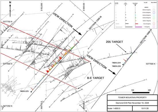
Figure 1.0 Bench Target Diamond Drill Plan – November 10, 2026
Table 2.0 summarizes the highlights of holes disclosed in this news release.
Infill Drill Results
TM26-225 (Figures 1.0 and 2.0) was drilled from south to north, targeting the 700-metre long, 250-metre wide B-E Trend at a depth of 250 metres from surface, which is the approximate center of the current MRE pit shell. The hole scissors TM26-218 (298.5 metres averaging 0.409 g/t Au) and the bottom of TM25-186X (19.5 metres averaging 0.523 g/t Au).
Both contacts were intersected within 10 metres of the currently projected contact. The southern (upper) contact was intersected at a depth of 175.5 metres downhole, and the northern contact was intersected at a depth of 564.0 metres. TM26-225 intersected 0.531 g/t Au over 388.5 metres (True Width 245.1 metres) within the targeted B-E Trend (Reference Table 2.0 and Figure 2.0).
Gold mineralization occurs in a variably brecciated and altered mix of volcanic tuffs and calc-alkalic intrusive rocks that are proportionately equal (50-50). Brecciation ranges from weak to intense. The breccias have been weakly to intensely altered by multiple, distinct, alteration assemblages.
Carbonate alteration is pervasive throughout the hole. Silicification is also ubiquitous. Hematite, chlorite, sericite and potassic alteration are patchy, typically observed over intervals of up to 50.0 metres in length.
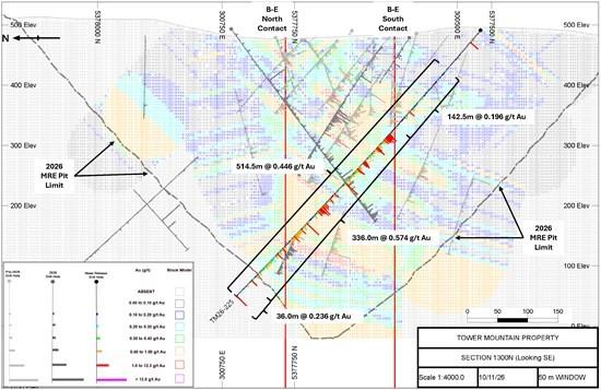
Figure 2.0 Cross Section 1300 N (TM26-225 B-E Target) Looking SE – November 10, 2026
Pyrite, closely associated with the gold mineralization, is persistent throughout the hole which is typical throughout the deposit. Pyrite content ranges from 0.5 to 5.0%.
Table 3.0 summarizes TM26-225 results at various cut-off grades from 0.0 g/t Au to 1.00 g/t Au. A minimum horizontal width of 6.0 metres (9.0 metre interval length) was used for both mineralized and non-mineralized interval selection.
Approximately 80% of TM26-225 returned continuous sustained intervals greater than 0.20 g/t Au over a minimum horizontal width of 6.0 metres. Approximately 57% of TM26-225 returned sustained intervals greater than 0.40 g/t Au over a minimum horizontal width of 6.0 metres (Reference Table 3.0).
*Table 2.0 – November 10, 2026, Significant Results
| Hole ID | From | To | Length | Grade | True Width |
| (m) | (m) | (m) | (Au g/t) | (m) | |
| TM26-224 | 2.5 | 36.0 | 33.5 | 0.094 | UNKNOWN |
| and | 36.0 | 42.0 | 6.0 | 0.798 | UNKNOWN |
| and | 42.0 | 97.5 | 55.5 | 0.070 | UNKNOWN |
| and | 97.5 | 121.5 | 24.0 | 0.152 | UNKNOWN |
| and | 121.5 | 292.5 | 171.0 | 0.042 | UNKNOWN |
| and | 292.5 | 300.0 | 7.5 | 0.111 | UNKNOWN |
| TM26-225 | 3.4 | 600.0 | 596.6 | 0.398 | UNKNOWN |
| includes | 3.4 | 175.5 | 172.1 | 0.132 | UNKNOWN |
| and | 175.5 | 564.0 | 388.5 | 0.531 | 245.1 |
| includes | 228.0 | 264.0 | 36.0 | 1.000 | 22.7 |
| and | 300.0 | 345.0 | 45.0 | 0.655 | 28.4 |
| and | 385.5 | 405.0 | 19.5 | 1.237 | 12.3 |
| and | 427.5 | 507.0 | 79.5 | 0.598 | 50.2 |
| and | 564.0 | 600.0 | 36.0 | 0.236 | 22.7 |
| includes | 598.5 | 600.0 | 1.5 | 2.957 | 0.9 |
| TM26-226 | 3.0 | 79.5 | 76.5 | 0.063 | UNKNOWN |
| and | 79.5 | 141.0 | 61.5 | 0.196 | UNKNOWN |
| includes | 79.5 | 81.0 | 1.5 | 1.170 | UNKNOWN |
| and | 115.5 | 141.0 | 25.5 | 0.255 | UNKNOWN |
| includes | 123.0 | 124.5 | 1.5 | 1.080 | UNKNOWN |
| and | 141.0 | 300.0 | 159.0 | 0.075 | UNKNOWN |
**Table 3.0 – November 10, 2026, Results at Select Cut-off Grades
| Hole ID | Cut-off grade | From | To | Length | Grade | True Width |
| (Au g/t) | (m) | (m) | (m) | (Au g/t) | (m) | |
| TM26-224 | 0.00 | 2.5 | 300.0 | 297.5 | 0.079 | UNKNOWN |
| includes | 0.20 | 30.0 | 42.0 | 12.0 | 0.469 | UNKNOWN |
| and | 97.5 | 121.5 | 24.0 | 0.152 | UNKNOWN | |
| TM26-225 | 0.00 | 3.4 | 600.0 | 596.6 | 0.398 | 377.1 |
| includes | 0.20 | 87.0 | 100.5 | 13.5 | 0.239 | 8.5 |
| and | 120.0 | 192.0 | 72.0 | 0.222 | 45.5 | |
| and | 208.5 | 600.0 | 391.5 | 0.527 | 247.4 | |
| includes | 0.40 | 178.5 | 192.0 | 13.5 | 0.417 | 8.5 |
| and | 213.0 | 340.5 | 127.5 | 0.673 | 80.6 | |
| and | 363.0 | 414.0 | 51.0 | 0.740 | 32.2 | |
| and | 429.0 | 574.5 | 145.5 | 0.470 | 92.0 | |
| TM26-226 | 0.00 | 3.0 | 300.0 | 297.0 | 0.096 | UNKNOWN |
| includes | 0.20 | 79.5 | 99.0 | 19.5 | 0.203 | UNKNOWN |
| and | 115.5 | 129.0 | 13.5 | 0.309 | UNKNOWN |
*True width is estimated where sufficient data allows. Where True Width is not estimated it is due to insufficient information at this time.
**Minimum horizontal width of 6.0 metres (=9.0 metres interval length).
Exploration Drill Results
Holes TM26-224 and TM26-226 targeted the vertical projection of the “205 Target“, a new target initially identified by hole TM26-205 (121.5 metres averaging 0.376 g/t Au). The 205 Target is located east of and below the current MRE pit limit. The current MRE estimates the entire area as waste due to a lack of any drilling. The 205 Target is located approximately 300 metres east of the projected northern contact of the B-E Trend (Reference Figure 3.0).
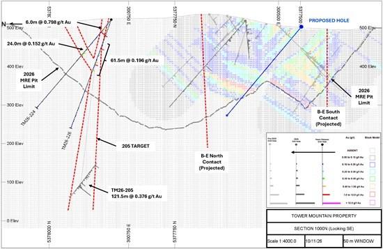
Figure 3.0 Cross Section 1000 N (TM26-224 & 226 – 205 Target) Looking SE – November 10, 2026
The 205 Target occurs in the core of the TMIC, in non-descript, massive, un-mineralized diorite. Rare, centimetre scale quartz-carbonate-pyrite veins appear to control the plus 1.0 g/t Au population with lower grade mineralization spreading outward from the vein sets.
TM26-224 intersected two distinct interval approximately 100 metres from surface, averaging 0.469 g/t Au over 12.0 metres and 0.152 g/t over 24.0 metres.
TM26-226, approximately 75 metres below TM26-224 and 300 metres above TM26-205, intersected a semi-continuous interval averaging 0.196 g/t over 61.5 metres (Reference Figure 3.0 and Table 3.0).
As with the B-E Target, gold grades appear to be more scattered and diffuse in the upper levels of the 205 Target.
MRE Reconciliation
Reconciliation of drill results to date for the B-E Trend relative to the 2026 MRE model suggest an overall grade increase relative to model-predicted grades and there is no indication of systemic bias. Figure 4.0 presents a summary of model-predicted grades compared to actual drilled grade for the fifteen (15) infill holes that post-date the 2026 MRE model.
The results, on a hole-by-hole basis, range from a low of -73% (TM26-219) to a high of 97% (TM26-210). This is typical and within expected tolerances. On a length-weight average basis, the comparison suggests that actual drilled grade of all fifteen (15) holes is currently 5% greater than the modeled grade predicted by the 2026 MRE.
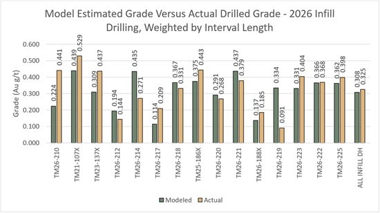
Figure 4.0 – Modelled Grade Versus Drilled Grade, Infill Drilling, 2026; Weighted by Interval Length
Similar results are observed for the project to date exploration drill (Reference Figure 5.0).
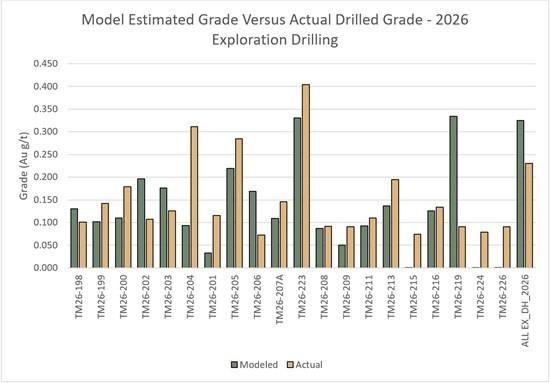
Figure 5.0 – Modelled Grade Versus Drilled Grade, Exploration Drilling, 2026; Weighted by Interval Length
Mineralization intersected outside the 2026 MRE model limit, specifically, the high-grade results intersected in holes TM26-210 and TM23-137X that extend beyond the base of the 2026 MRE model, are not considered in the comparative analysis.
Quality Assurance and Quality Control
Diamond drilling utilizes NQ diameter tooling. The core is received at the on-site logging facility where it is photographed, logged for geotechnical, physical properties and geological data. Samples are identified, recorded, and cut in half by wet diamond saw. Half the core is sent for assay at an accredited laboratory with the remaining half core stored on site. A standard sample length of 1.5 meters is typically employed, varying only at major lithological contacts.
Certified standards and blanks are randomly inserted into the sample stream and constitute approximately 10% of the sample stream. Certified standards and blank performance is monitored with any failures evaluated and investigated to determine if said failure is a result of error during submission. Any unexplained failures are identified and the five samples preceding and following the failure are re-assayed. Commencing in 2026, duplicate pulps are prepared at a rate of 1 in every 20 samples. The duplicate pulps are sent to a second independent analytical facility for analyses.
Activation Laboratories Ltd., Thunder Bay, Ontario, ISO/IEC 17025:2017 is the primary independent analytical service provider.
AGAT Laboratories, Thunder Bay, Ontario, ISO/IEC 17025:2017 is the secondary, independent analytical facility.
Samples are, received, dried, crushed to 80% passing 2.0 mm. A 250-gram sample is split and pulverized. Samples are analyzed for gold using a 30-gram lead collection fire assay fusion (FA) with an atomic absorption (AAS) finish. All assay results greater than 5.0 g/t Au are re-assayed using a gravimetric analysis. All assays greater than 30.0 g/t Au are re-assayed using screen metallics where a representative 1000-gram sample is split sieved at 149µm. Assays are performed on the entire +149 µm fraction and two splits of the -149 µm fraction. A final assay is calculated based on the weight of each size fraction.
Qualified Person
Technical information in this news release has been reviewed and approved by Wes Hanson, P.Geo., President and CEO of Thunder Gold Corp., who is a Qualified Person under the definitions established by NI 43-101.
About the Tower Mountain Gold Property
The 7,625-hectare, 100%-owned Tower Mountain Property is beside the Trans-Canada highway, 40-km west of Thunder Bay, Ontario (pop. 120,000). Gold mineralization occurs in variably brecciated and altered rocks surrounding the calc-alkalic Tower Mountain Intrusive Complex. Drilling to date has established an initial mineral resource parallel to the western contact of the intrusion representing approximately 25% of the TMIC halo.
The MRE has an effective date of January 19, 2026. A Technical Report titled “NI 43-101 Technical Report for the 2026 Mineral Resource Estimate on the Tower Mountain Project, Ontario, Canada.” is available on the Company’s website at www.thundergoldcorp.com and on SEDAR+ (www.sedarplus.ca) under the Company’s Issuer profile.
The Report was prepared by Charley Murahwi, P.Geo., FAusIMM.; William Lewis, P.Geo., Tudorel Ciuculescu, P.Geo., and Richard Gowans, P.Eng., all of Micon International Limited, Toronto, Ontario, Canada. The Report was prepared in accordance with National Instrument 43-101 Standards of Disclosure for Mineral Projects (“NI 43-101”) and CIM Definition Standards of Mineral Resources and Mineral Reserves.
The MRE is summarized as follows:
Tower Mountain Mineral Resource Estimate – January 19, 2026
| Category | Tonnage (Mt) |
Grade (g/t Au) |
Contained Metal (‘000 oz gold) |
| Indicated | 34.5 | 0.46 | 514 |
| Inferred | 211.1 | 0.45 | 3,053 |
Notes:
The remaining 75% of the TMIC halo demonstrates similar geology, alteration, and geophysical signatures and is untested by drilling.
A second gold trend, identified in 2026, outcrops at surface and is continuously mineralized over a 100-metre width. This gold mineralization occurs within Timiskaming-type conglomerates that have been traced for over 5.0 kilometres along a southwest trend paralleling the Thunder Lake Fault. The Company believes both targets offer opportunities to materially increase the total resource through systematic drilling.
About Thunder Gold Corp.
Thunder Gold is advancing the Tower Mountain project in Thunder Bay, Ont. — an emerging gold system with the scale, consistency and quality to support a long-life, open-pit operation. Results from the disciplined drill programs have consistently reinforced confidence in the continuity and predictability of the discovery while highlighting significant potential for expansion across multiple zones of the Tower Mountain intrusive complex. With industry-leading drilling costs, existing infrastructure and a skilled local work force, Tower Mountain represents a rare combination of size, scalability and cost-effective growth.
At Thunder Gold, our vision is clear: to unlock a discovery that has the potential to become a transformational gold project, delivering long-term value for shareholders while contributing to the future of Canada’s mining industry.
NexGold Mining Corp. (TSX-V: NEXG) (OTCQX: NXGCF) is pleased to ... READ MORE
Premier American Uranium Inc. (TSX-V: PUR) (OTCQB: PAUIF) is plea... READ MORE
Copper-bearing mineralization logged in all eight holes along an ... READ MORE
Highlights Three-hole shallow drill program completed at Destiny.... READ MORE