







GreenLight Metals Inc. (TSX-V: GRL) (OTCQB: GRLMF) is pleased to announce assay results from step-out holes B26-015 and B26-013 at its Bend copper-gold volcanogenic massive sulfide Project in Taylor County, Wisconsin. Both holes intersected massive to semi-massive sulfides along the interpreted copper-zone trend to the east. B26-015, drilled approximately 50 metres east of the B26-008/B26-010 section, returned a broad copper-gold interval comparable in width and grade to those holes, and B26-013 intersected massive sulfide on a section approximately 60 metres farther east.
Highlights
“B26-015 is among the best results of our Phase 2 program: more than 25 metres of copper-gold mineralization, including 6.21 metres grading 2.34% copper and 1.85 g/t gold,” said Matt Filgate, President, CEO and Director of GreenLight. “Taken together with the thick interval of massive to semi-massive sulfide we logged about 55 metres down-dip in B26-016, where assays are pending, it supports our view that the system continues down plunge to the east. As we finish Phase 2 with B26-018 and receive the remaining assays, we’re building a clearer picture of where to focus our next drill program.”
Table 1: Summary of Significant Intercepts – B26-015 & B26-013
| DDH | From (m) |
To (m) |
Interval (m) |
Cu (%) |
Au (g/t) |
Ag (g/t) |
CuEq (%) |
| B26-015 | 427.90 | 453.07 | 25.17 | 1.30 | 1.30 | 13.87 | 2.69 |
| Including | 427.90 | 434.74 | 6.84 | 1.64 | 1.04 | 14.66 | 2.74 |
| Including | 445.66 | 451.87 | 6.21 | 2.34 | 1.85 | 29.18 | 4.39 |
| B26-013 | 384.19 | 389.39 | 5.20 | 0.89 | 0.99 | 9.16 | 1.95 |
| Including | 386.65 | 389.39 | 2.74 | 1.51 | 1.71 | 16.02 | 3.33 |
| All intervals are drilled lengths, and composite grades are length-weighted. True thickness is estimated at approximately 80% of drilled length for B26-015 and is currently unknown for B26-013 because of limited nearby data. “Including” intervals are contained within the broader interval and are not additional mineralized lengths. Tellurium is not reported because several samples exceeded the 500 ppm upper limit of the multi-element method. CuEq is a calculated grade combining the reported copper, gold and silver grades using assumed metal prices and metallurgical recoveries. It is not a proxy for, or evidence of, economic value. Tellurium is excluded. Assumptions are US$4.50/lb copper, US$3,600/oz gold, US$40/oz silver and 90% recovery for each metal, consistent with the Company’s April 27, June 2 and July 22, 2026 releases. CuEq values are calculated from unrounded grades. CuEq (%) = [(Cu (%) / 100 × 0.90 × 2204.6 × 4.50) + (Au (g/t) × 0.90 / 31.1035 × 3600) + (Ag (g/t) × 0.90 / 31.1035 × 40)] / (2204.6 × 0.01 × 4.50). The recovery assumptions are based on a preliminary assessment of analogous VMS deposits and preliminary, historical metallurgical testwork completed by past operators of the Bend Project; actual recoveries and payabilities are unknown and may differ materially. The calculation does not include smelting or refining charges, penalties, deleterious elements or payability adjustments. |
|||||||
Phase 2 Drilling Results and Geological Context
The Phase 2 program is testing two related styles of mineralization at Bend: copper-gold mineralization in massive to semi-massive sulfide lenses and broader gold-bearing mineralization in the underlying footwall crystal tuff. Phase 2 has extended drill-tested mineralization at depth and improved the definition of both zones, supporting continued testing of the copper-gold zone along its interpreted 45°-50° eastward plunge and of the gold mineralization along strike and at depth.
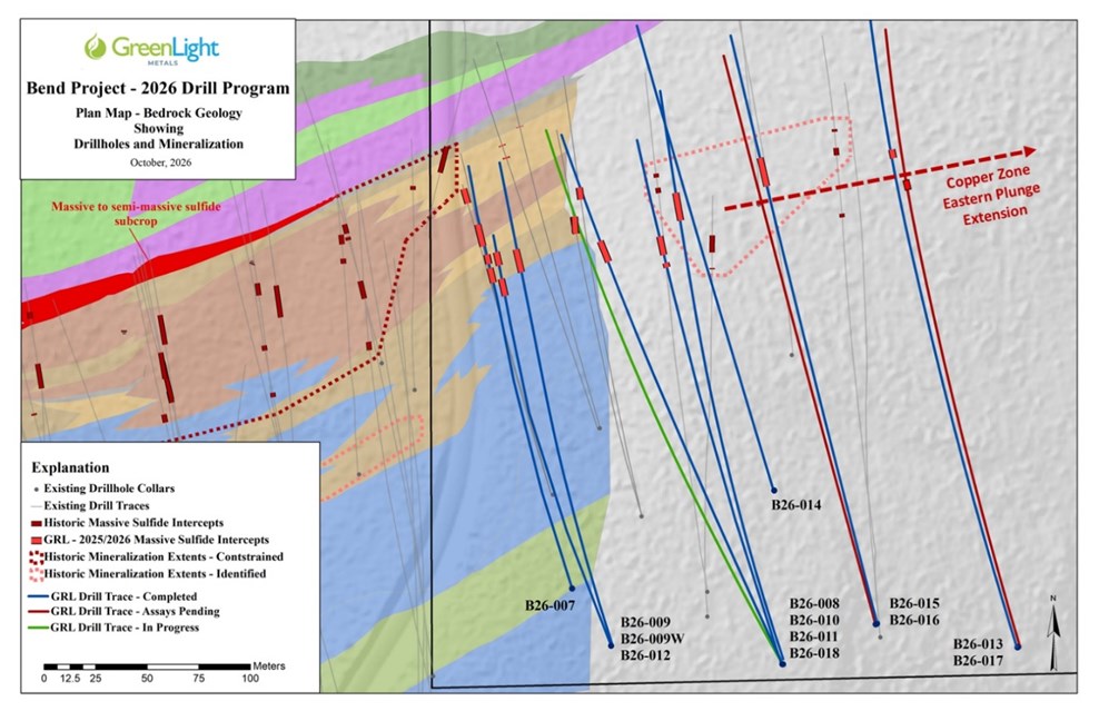
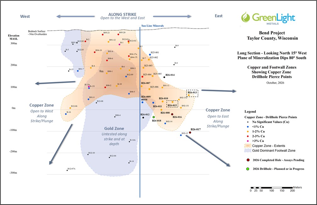
Recent Phase 2 drilling includes four holes (B26-013, B26-015, B26-016 and B26-017) testing the extension of the copper-gold zone along its interpreted plunge, east of the copper-gold intersections reported earlier in the program (see Figures 1 and 2 and Table 2). All four holes intersected VMS-style semi-massive to massive sulfide mineralization. B26-015 and B26-016, drilled from a site approximately 50 metres east of the B26-008/B26-010 section, intersected thick sulfide intervals, and the broad copper-gold interval in B26-015 supports the interpretation that the mineralized ‘core’ of the zone continues east along the projected plunge. B26-013 and B26-017, drilled from a site approximately 60 metres farther east, intersected thinner zones of semi-massive to massive sulfides. B26-013 intersected a discrete massive sulfide interval interpreted to lie near the up-dip margin of the copper-gold zone. B26-017, approximately 225 metres below B26-013, intersected 2.95 metres of semi-massive sulfides at the base of a 26.05-metre sequence of mineralized crystal tuff. Logged sulfide abundance in this intersection is greater than recorded in nearby historical hole B92-15, to the west at a similar depth, supporting follow-up targeting up-dip of B26-017 on this section.
B26-018, currently in progress, is designed to test the transition in mineralization style between the footwall gold-dominant mineralization in B26-009W and B26-012 and the copper-gold mineralization in B26-008 and B26-011. Its results will help guide targeting of both the copper-gold zone and the footwall gold zone in the next drill program.
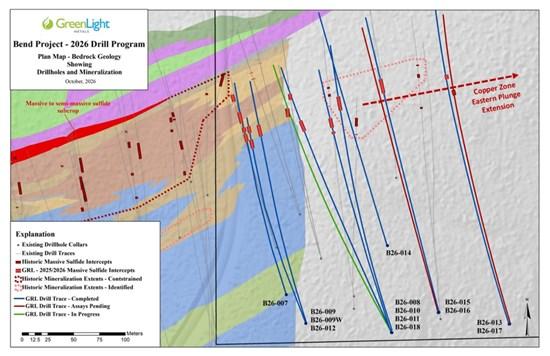
Figure 1: Phase 2 Drill Program Plan Map
To view an enhanced version of this graphic, please visit:
https://images.newsfilecorp.com/files/7506/320320_5d9e63a1c405eb08_001full.jpg
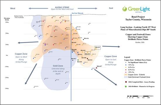
Figure 2: Phase 2 Drill Program Long Section
To view an enhanced version of this graphic, please visit:
https://images.newsfilecorp.com/files/7506/320320_5d9e63a1c405eb08_002full.jpg
Table 2: Previously Reported Results – Phase 2 Program
| Hole | Length (m) |
Cu (%) |
Au (g/t) |
Geological setting | News release (2026) |
| B26-007 | 30.70 | 1.05 | 1.34 | Copper zone | April 27 |
| B26-008 | 27.72 | 1.07 | 0.97 | Copper zone | June 2 |
| B26-010 | 21.06 | 1.32 | 1.07 | Copper zone | June 2 |
| B26-011 | 18.75 | 0.53 | 0.93 | Copper zone | July 22 |
| B26-009W | 52.18 | 0.08 | 1.12 | Gold-bearing footwall | July 22 |
| B26-012 | 55.90 | 0.04 | 0.88 | Gold-bearing footwall | September 22 |
| These are selected earlier results, not newly reported assays. All intervals are drilled lengths; true-width estimates are hole-specific. Refer to the cited releases for full assay tables, inclusions, true-width estimates and technical disclosure. B26-014, reported on September 22, 2026, returned no significant assay results. | |||||
Hole Details
The recurrence of pyrite-chalcopyrite sulfides in the same interpreted stratigraphic setting at successive drill positions is encouraging for the continuity of the targeted mineralized horizon. The significant thicknesses of the mineralized intervals encountered in B26-015 and B26-016 further support the projected plunge of the ‘core’ of the copper zone and support further testing of the zone along this trend to the east. Final surveys, logging and assays will refine the relationship between the intersections and guide follow-up targeting.
The B26-016 and B26-017 descriptions are visual core-logging observations, not assay results. Assays are required to determine metal grades. The reported visual intervals are drilled lengths and include internal quartz-vein and tuff intervals; true widths are provided where surrounding data are sufficient to provide reasonable estimates.
Next Steps
Table 3: Drill Collar Information
| Hole ID | Easting (m) |
Northing (m) |
Elevation (masl) |
Azimuth (°) |
Dip (°) |
Total Depth (m) |
| B26-012 | 688519 | 5018496 | 414 | 343 | 74 | 569.06 |
| B26-013 | 688715 | 5018496 | 406 | 343 | 57 | 624.23 |
| B26-014 | 688597 | 5018572 | 410 | 342 | 58 | 413.92 |
| B26-015 | 688648 | 5018508 | 410 | 344 | 62 | 541.93 |
| B26-016 | 688648 | 5018508 | 410 | 344 | 69 | 596.80 |
| B26-017 | 688715 | 5018496 | 406 | 344 | 71 | 742.19 |
| B26-018 | 688602 | 5018488 | 412 | 333 | 73 | In progress |
| Coordinates: NAD83 UTM Zone 15N. Collar locations are planned or field-spotted; final high-resolution collar surveys are pending. Azimuths and dips are collar gyro readings; dips are expressed as positive angles below horizontal. | ||||||
About the Bend Project
The Bend Project is an exploration-stage copper-gold VMS project in Taylor County, Wisconsin, approximately 30 kilometres north-northwest of Medford. GreenLight’s interests are held through Green Light Wisconsin LLC and include the leased forty-acre Soo Line mineral parcel and a pending prospecting permit application over approximately 519 acres of adjacent federal mineral estate.
Historical and GreenLight drilling across the Bend property totals approximately 30,440 metres in 70 primary drill holes and two wedge branches as of October 20, 2026, including B26-018 in progress. GreenLight’s 2025-2026 drilling accounts for approximately 8,630 metres in 18 primary holes and one wedge branch.
A 1992 historical estimate outlined approximately 4.0 million tonnes grading 1.74% copper, 2.44 g/t gold and 11.56 g/t silver.¹ The estimate provides historical context for the project; it is not a current mineral resource. A Qualified Person has not done sufficient work to classify the historical estimate as a current mineral resource, and GreenLight is not treating it as a current mineral resource.
¹ Primary source: E.K. Lehmann and Associates, Inc. (1992), Report of the Geology and Ore Reserves of the Bend Copper-Gold Deposit, Taylor County, Wisconsin, prepared for the Jump River Joint Venture. The estimate used approximately 33 drill holes and averaged polygonal and cross-sectional estimates. It was described as a “geologic resource” under U.S. Geological Survey Circular 831 (1980), not a current CIM mineral resource category. No cut-off grade or complete set of estimation assumptions is available in the records reviewed. Its reliability is limited by its age, incomplete supporting records and exclusion of subsequent drilling, including the later historical programs and GreenLight’s 2025-2026 work. Reconciliation and verification of collars, surveys, assays, density data, geological interpretations and QA/QC records, together with any additional drilling or sampling required by the Qualified Person, would be required before preparation of a current estimate under CIM Definition Standards. The historical estimate should not be relied upon as a current mineral resource or mineral reserve.
Sample Preparation and QA/QC
A strict chain of custody was maintained from core collection through shipment to ALS, an independent laboratory. NQ-size drill core (47.6-millimetre diameter) was transported to GreenLight’s secure Medford-area core facility for geological logging, photography and sampling. Mineralized and adjacent unmineralized intervals were cut lengthwise using an electric saw; one half was submitted for analysis and the remaining half retained. Sample lengths generally ranged from 0.5 to 1.5 metres, subject to geological contacts. Samples were placed in labelled, sealed bags and shipped by ground courier to ALS in Twin Falls, Idaho, for preparation; analyses were completed at ALS in North Vancouver, British Columbia.
Samples were prepared using ALS method PREP-31Y: drying where required, crushing to at least 70% passing 2 millimetres, rotary splitting of a 250-gram sub-sample and pulverizing the split to 85% passing 75 micrometres. Gold was analyzed using Au-ICP21, a 30-gram fire assay with an ICP-AES finish and a reporting range of 0.001-10 ppm Au; samples exceeding the upper limit are re-analyzed using a gravimetric finish. Multi-element analysis, including tellurium, used ME-MS61, a four-acid digestion of a 0.25-gram split with ICP-MS/ICP-AES determination. Samples returning more than 1% copper were re-analyzed using Cu-OG62, a four-acid digestion with an ICP-AES finish. Samples returning more than 500 ppm tellurium are being re-analyzed using Te-AA62 with an atomic-absorption finish.
Certified reference materials and blanks were inserted into the sample stream and together represented approximately 10% of submitted samples. Quality-control results for the copper and gold analyses of B26-013 and B26-015 were reviewed and found to be acceptable.
Qualified Person Statement
The technical information in this news release has been prepared under the supervision of, and reviewed and approved by, Thomas Quigley, MSc, CPG-11962, Exploration Director of the Company, a Qualified Person as defined by National Instrument 43-101 – Standards of Disclosure for Mineral Projects.
About GreenLight Metals Inc.
GreenLight is a Wisconsin-focused exploration company advancing copper-gold and gold projects across the Penokean Volcanic Belt (one of North America’s most prospective VMS districts) and the Kalium Canyon epithermal gold project in Nevada’s Walker Lane, which is subject to a staged earn-in and joint venture arrangement with Barrick Mining Corporation. In Wisconsin, GreenLight’s portfolio includes the Bend copper-gold deposit, the Reef high-grade gold project, and the Lobo and Lobo East massive sulfide targets. GreenLight’s flagship Bend Project is posted on the U.S. Federal Permitting Dashboard as a FAST-41 Transparency Project, providing a public framework for tracking applicable federal review and authorization milestones and coordinated support through the Permitting Council. Guided by a team with deep roots in the state, GreenLight is building a modern minerals company for Wisconsin, by Wisconsin, committed to responsible exploration, transparent engagement, and creating durable local opportunities as it helps supply the critical metals that power the energy transition.
For more information, please contact:
Matt Filgate
President & CEO, Director
(778) 679-3579
matt@greenlightmetals.com
www.greenlightmetals.com
Santacruz Silver Mining Ltd. (NASDAQ: SCZM) (TSX: SCZ) announces that total production in the third ... READ MORE
White Gold Corp. (TSX-V: WGO) (OTCQX: WHGOF) (FSE: 29W) is pleased to announce that further to its p... READ MORE
Canagold Resources Ltd. (TSX: CCM) (OTCQB: CRCUF) (FSE: CANA) announces assay results from three add... READ MORE
Liberty Gold Corp. (TSX: LGD) (OTCQX: LGDTF) is pleased to report initial drill assays results, comp... READ MORE