








High-grade sub-intervals of 17.93 g/t gold over 4.6 meters, 5.56 g/t gold over 15.2 meters and 5.22 g/t gold over 7.6 meters
Occidental South is rapidly taking shape as a potentially significant new discovery, with excellent continuity of thick, high-grade, near surface gold-silver mineralization
Continuous mineralization defined across 550 meters of strike length on nominal 50-meter spaced sections; the zone remains open on all sides
Systematic drilling underway across initial 1km strike of the 5km Occidental-Brunswick Lode
45 drill holes and 9,300 meters completed to date out of a planned initial 20,000-meter, 100-hole drill program; assays pending for 30 holes
Mackay Gold & Silver Corp. (TSX-V: MACK) (OTCQB: MKGSF) is pleased to announce the second batch of drill results from the Company’s inaugural 20,000-meter drill program at its 100%-owned Comstock District property in Nevada, USA. Assay results are reported for 8 new drill holes (RC holes 8 through 15) drilled from three separate drill pads and include multiple strong intersections of near-surface gold and silver, with typical true widths ranging from approximately 50m to 100m, as detailed in Table 1 and Figures 1 to 5.
“Occidental South is quickly evolving into what appears to be a significant new discovery, with early drill results demonstrating the key attributes of grade, width and continuity,” stated Darwin Green, CEO and Director. “The current drill plan at Occidental South is targeting shallow oxide mineralization across an initial 1 km strike length of the 5 km long Occidental-Brunswick lode, which has seen limited modern exploration. With just 15 holes reported from the ongoing 100-hole program we are off to a great start.”
Drill Result Highlights
Drill holes 26MGS013, 014 and 015 were all drilled on the same section, intersecting the mineralized zone at nominal 50-meter spacing and defining a moderate easterly dip. Approximately 150-meters of down-dip continuity has been defined from where the zone is interpreted to project to surface (Figure 1) and the mineralized zone is open down dip.
Table 1. Significant Drill Intersections.
| Drillhole | From (ft) | To (ft) | Length (ft) | Length (m) | Au g/t | Ag g/t | ||||||||||||||||||||||||||||
| 26MGS008 | no significant values (did not reach target) | |||||||||||||||||||||||||||||||||
| 26MGS009 | 30 | 40 | 10 | 3.05 | 0.85 | 4.7 | ||||||||||||||||||||||||||||
| 26MGS009 | 85 | 95 | 10 | 3.05 | 0.62 | 4.7 | ||||||||||||||||||||||||||||
| 26MGS009 | 220 | 230 | 10 | 3.05 | 0.48 | 4.5 | ||||||||||||||||||||||||||||
| 26MGS010 | 0 | 20 | 20 | 6.10 | 0.19 | 1.8 | ||||||||||||||||||||||||||||
| 26MGS010 | 85 | 185 | 100 | 30. | .85 | 11.2 | ||||||||||||||||||||||||||||
| Incl. | 155 | 180 | 25 | 7.62 | 1.49 | 17.0 | ||||||||||||||||||||||||||||
| 26MGS010 | 370 | 480 | 110 | 33. | .59 | 3.6 | ||||||||||||||||||||||||||||
| 26MGS010 | 525 | 570 | 45 | 13.72 | 0.53 | 4.1 | ||||||||||||||||||||||||||||
| 26MGS011 | 0 | 65 | 65 | 19.81 | 0.13 | 1.2 | ||||||||||||||||||||||||||||
| 26MGS011 | 255 | 405 | 150 | 45.72 | 1.17 | 6.1 | ||||||||||||||||||||||||||||
| Incl. | 340 | 405 | 65 | 19.81 | 2.08 | 9.6 | ||||||||||||||||||||||||||||
| 26MGS012 | 5 | 145 | 140 | 42.67 | 0.35 | 5.3 | ||||||||||||||||||||||||||||
| 26MGS012 | 265 | 285 | 20 | 6.10 | 0.85 | 4.9 | ||||||||||||||||||||||||||||
| 26MGS012 | 335 | 370 | 35 | 10.67 | 0.86 | 1.6 | ||||||||||||||||||||||||||||
| 26MGS013 | 70 | 85 | 15 | 4. | .44 | 1.4 | ||||||||||||||||||||||||||||
| 26MGS013 | 260 | 490 | 230 | 70.10 | 1.17 | 7.8 | ||||||||||||||||||||||||||||
| Incl. | 350 | 435 | 85 | 25.91 | 2.35 | 8.3 | ||||||||||||||||||||||||||||
| Incl. | 360 | 400 | 40 | 12.19 | 4.13 | 12.5 | ||||||||||||||||||||||||||||
| Incl. | 360 | 385 | 25 | 7.62 | 5.22 | 17.8 | ||||||||||||||||||||||||||||
| 26MGS014 | 45 | 70 | 25 | 7.62 | 0.31 | 1.3 | ||||||||||||||||||||||||||||
| 26MGS014 | 170 | 185 | 15 | 4.57 | 0.80 | 3.2 | ||||||||||||||||||||||||||||
| 26MGS014 | 235 | 455 | 220 | 67.06 | 2.30 | 8.7 | ||||||||||||||||||||||||||||
| Incl. | 310 | 425 | 115 | 35.05 | 4.07 | 14.8 | ||||||||||||||||||||||||||||
| Incl. | 325 | 340 | 15 | 4.57 | 17.93 | 29.2 | ||||||||||||||||||||||||||||
| 26MGS014 | 715 | 880 | 165 | 50.29 | 0.30 | 1.5 | ||||||||||||||||||||||||||||
| Incl. | 850 | 870 | 20 | 6.10 | 1.42 | 3.3 | ||||||||||||||||||||||||||||
| 26MGS014 | 910 | 1000 | 90 | 27.43 | 0.36 | 6.2 | ||||||||||||||||||||||||||||
| Incl. | 925 | 950 | 25 | 7.62 | 0.73 | 9.7 | ||||||||||||||||||||||||||||
| 26MGS015 | 225 | 545 | 320 | 97.54 | 1.48 | 5.5 | ||||||||||||||||||||||||||||
| Incl. | 460 | 545 | 85 | 25.91 | 3.90 | 7.0 | ||||||||||||||||||||||||||||
| Incl. | 480 | 530 | 50 | 15.24 | 5.56 | 7.0 | ||||||||||||||||||||||||||||
| Incl. | 505 | 510 | 5 | 1.52 | 26.40 | 13.9 | ||||||||||||||||||||||||||||
| 26MGS015 | 790 | 825 | 35 | 10.67 | 0. | .8 | ||||||||||||||||||||||||||||
Reported thickness are drilled thickness, true thickness estimated at 80% to 100% of drilled thickness
Reported intersections based on a 0.1 g/t cut-off with maximum of 20 ft internal dilution below cut-off
Holes 26MGS008 and 009 stopped short of the projected main mineralized zone
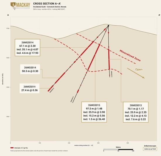
Figure 1. Cross section A–A’ for Occidental South drill area, looking N-NE
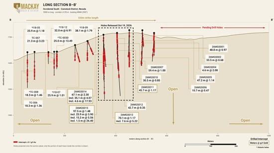
Figure 2. Long section B–B’ for Occidental South drill area, looking W-NW
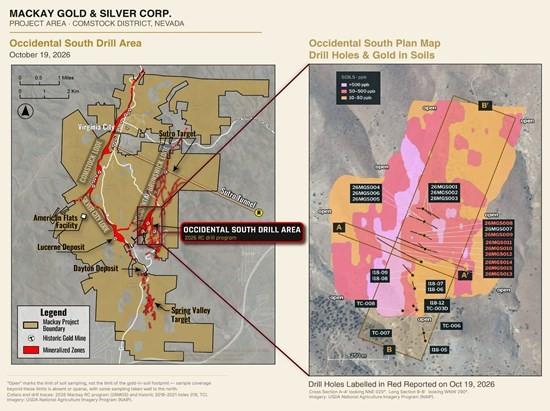
Figure 3. Project Map & Plan Map of Occidental South drill holes, on gold-in-soil map
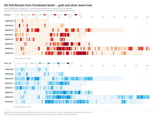
Figure 4. Gold and silver down hole grade ribbon for RC drill results reported in this news release
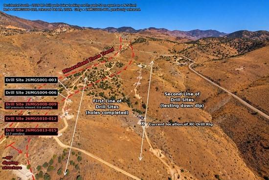
Figure 5. Occidental South looking north, showing drill pads and holes reported in this news release (in red)
Drilling Details
The Phase 1 two-rig drill program consists of approximately 15,000 meters of shallow reverse circulation drilling at Occidental South and 5,000 meters of deep diamond core drilling at the Sutro Tunnel intersection. Both areas test the Occidental-Brunswick Lode, a three-mile-long (5-km) mineralized structure located east of, and parallel to, the Comstock Lode. The Occidental-Brunswick Lode shares the same strike, dip, and overall geological setting and character as its better-known neighbor.
At Occidental South, drill plans include 50 to 100-meter spaced drill holes over an approximately 1,000 x 400-meter gold-in-soil anomaly, targeting shallow bulk mineable gold. The drilling is on trend of an approximately 300-meter-long zone of oxide gold-silver mineralization as defined in outcrop and limited drilling by previous operators.
Today’s results are the second batch released from Mackay Gold & Silver’s inaugural drill program which commenced in mid-June. They include 8 drill holes completed from three drill pads spaced approximately 50 meters apart (Figures 1 to 5) located within a 150-meter gap between historical drill holes to the south and the Company’s first drill holes to the north (see news release dated September 15, 2026). Thick intervals of strong gold-silver mineralization, with true thicknesses of 25 to 100 meters, have now been defined continuously across the entire 550-meter strike length tested at Occidental South. Mineralization appears to dip moderately to the east-southeast and has been traced 150 meters down-dip to date. The zone remains open along strike to both the north and south and is open down dip.
Approximately 45 drill holes and 9,300 meters have been completed to date as part of the planned 20,000-meter 100-hole drill program. Drilling of the first 1 km strike length along the up-dip portion of Occidental South is complete. Drilling has moved to an eastern line of holes designed to test Occidental South up to 300 meters down-dip along the same 1 km strike length (Figure 5). The eastern line of holes will also test for potential mineralized zones above, or hanging wall to, the primary Occidental South mineralized zone. Assays have been received and reported for the first 15 drill holes of the program, and the Company anticipates providing regular updates over the next several months as additional assay results are received.
Occidental South is the first area tested by Mackay, and results to date highlight the prospectivity of the Occidental-Brunswick Lode which is undrilled over most of its 5-km length. The Occidental-Brunswick Lode is one of three major past-producing lodes within the Comstock District now controlled by Mackay Gold & Silver.
Mackay Gold & Silver Corp.
Mackay Gold & Silver Corp. is a Nevada-focused gold and silver exploration company with 100% control of a large, consolidated land package totaling 4,747 hectares (47.5 km²) in one of America’s richest, productive and oldest mining districts. With an estimated 8.2 million ounces of historical gold production and 192 million ounces of silver produced between 1859 and 1926 from so called ‘bonanza’ orebodies that averaged 35 g/t gold and 726 g/t silver, the Comstock district is recognized as one of America’s highest grade epithermal systems and an attractive setting for modern discovery. Led by an experienced team with a strong track record of discovery, development, and value creation, Mackay is well funded and committed to delivering shareholder value through disciplined exploration and responsible resource development.
Qualified Person
The scientific and technical information contained in this news release has been reviewed and approved by Darwin Green, Chief Executive Officer and director of the Company, and a Qualified Person under NI 43-101. Mr. Green is not independent of the Company.
Sage Potash Corp. (TSX-V: SAGE) (OTCQB: SGPTF) is pleased to anno... READ MORE
Nexus Uranium Corp. (CSE: NEXU) (OTCQB: NEXUF) (FSE: JA7) is plea... READ MORE
68 g/t Au over 0.85m from 262.85m to 263.7m in PAR-26-149 is the ... READ MORE
Evolve Royalties Ltd. (CSE: EVR; OTCQX: EVRYF) is pleased to anno... READ MORE
Tiger Gold Corp. (TSX-V: TIGR) (FSE: D150) (OTCQB: TGRGF) is plea... READ MORE