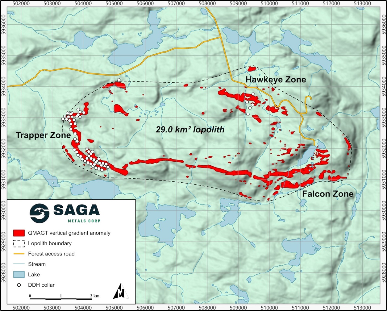
SAGA Metals Corp. (TSX-V: SAGA) (OTCQX: SAGMF) (FSE: 20H), a North American exploration company focused on critical mineral discoveries, is pleased to report the final assay results from the maiden Mineral Resource Estimate diamond drill program at the Trapper Zone of its 100%-owned Radar Titanium-Vanadium-Iron Project, near Cartwright, Labrador, Canada. The Trapper Zone forms part of an oxide-bearing lopolith that includes the Falcon and Hawkeye Zones collectively covering 29 square kilometres (Figure 1).
MRE PROGRAM HIGHLIGHTS:
These are the results the team has been drilling toward since the program began. Holes R-0088, R-0089, R-0090, R-0091 and R-0092 are the last assays outstanding from a campaign that was completed in August 2026. With them in hand, SAGA has a complete assay database for every hole drilled for the Trapper Zone resource. The validated database, geological model inputs, density data and QA/QC package are being turned over to GeoGlobal LLC. The independent NI 43-101 mineral resource estimate and technical report are expected this quarter.
This is the largest drill program in the Company’s history, and the first time Radar has had the dataset required to carry a zone from discovery into a resource. Eighty-five holes, R-0008 through R-0092, for 22,432 metres, were drilled in roughly eight months across Trapper North, Trapper Transition and Trapper South hitting oxide mineralization in every hole.
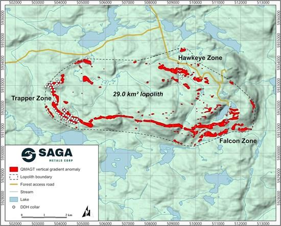
Figure 1: The Radar Property with the Dias QMAGT vertical gradient (Bzz) anomaly footprint shown in red (high-amplitude pixels only). The QMAGT-imaged central oxide-layering lopolith validated over 29 km2, encompassing the Trapper Zone, Hawkeye Zone, and the new Falcon Zone.
To view an enhanced version of this graphic, please visit:
https://images.newsfilecorp.com/files/12336/318858_sagaone.jpg
Analytical results received for the final five (5) diamond drill holes (R-0088 to R-0092) from the MRE drill program initiated in Q4 2025, continue to deliver consistent broad intercepts of oxide mineralization.
Key intercepts include:
Michael Garagan, CGO & Director of SAGA Metals, commented:
“This is the milestone the crew has been working toward since the first Trapper hole. Eighty-five holes, more than 22,000 metres, eight months, and oxide in every one of them. The final five holes delivered the same consistency of titanium, vanadium and iron mineralization from surface to depth, including another near-200-metre run in R-0092. I want to recognize the drillers, the geologists, the core loggers, the sample crews and the entire team in Cartwright who kept this program moving through a Labrador winter and summer. The database is now with GeoGlobal. The maiden resource for Trapper is the next deliverable, and we expect the NI 43-101 technical report this quarter.”
SAGA’s NI 43-101 MRE Finalization
SAGA has retained GeoGlobal LLC, of Riverton, Utah, to complete the independent mineral resource estimate and the supporting NI 43-101 technical report for the Trapper Zone. GeoGlobal is an independent mining advisory firm specializing in mineral deposit evaluation, advanced geostatistics, resource estimation and reporting, independent audits and reviews, and model-mine-mill reconciliation. The firm works to NI 43-101, S-K 1300, JORC and SAMREC standards.
The estimate is being led by Dr. Abani R. Samal, Ph.D., CPG, RM-SME, Fellow-SEG, Principal of GeoGlobal. Dr. Samal is a Qualified Person under NI 43-101 and JORC, has worked in the minerals industry since 1996, and is recognized for deposit evaluation, resource estimation and geostatistics.
GeoGlobal is currently working through the necessary sequence of tasks to finalize the technical report including validation of the collar, survey and assay database; review of QA/QC; construction of the geological and oxidation domains from the logged gabbronorite, semi-massive oxide and rhythmic oxide units; compositing and grade interpolation for Fe2O3, TiO2 and V2O5; density assignment; and classification under CIM Definition Standards. The maiden estimate will be under National Instrument 43-101 and expects to deliver the technical report this quarter.
Detailed Logging Highlights from Drill Hole R-00888 to R-0092
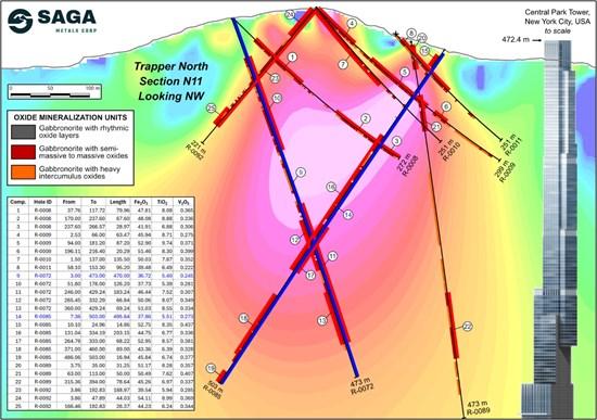
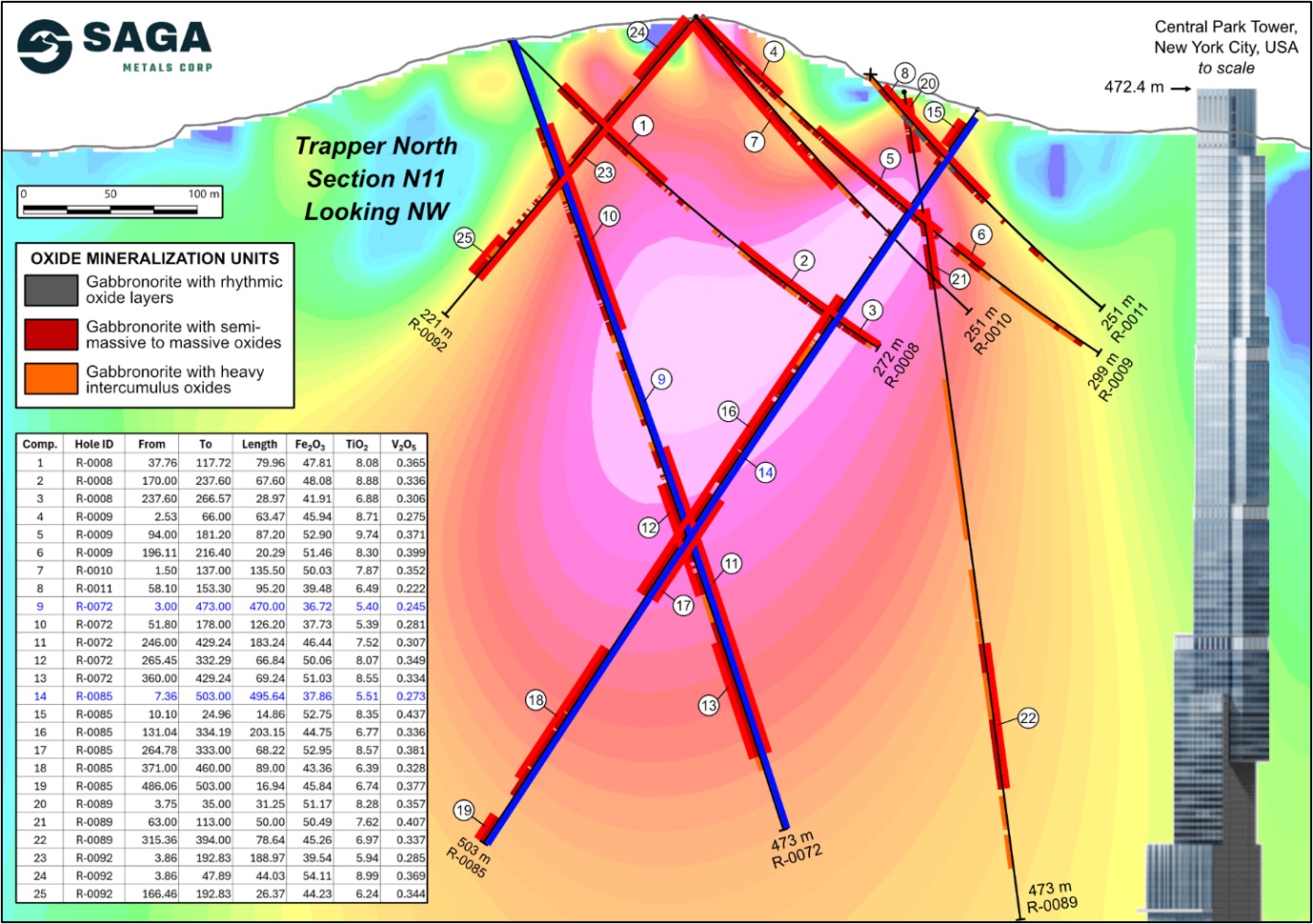
Figure 2: Cross section of N11 looking NW showing R-0008, R-0009, R-0010, R-0011, R-0072, R-0085, R-0089 and R-0092, highlighting intercepts of semi-massive oxides and layering sequence with the 3D Magnetic Inversion of the 2025 Trapper Zone ground magnetic survey. Assays shown for R-0008, R-0009, R-0010, R-0011, R-0072, R-0085, R-0089, and R-0092. Central Park Tower located in Manhattan, New York, the world’s largest residential building1 at 472.4 m, is used to contextualize the size of drill hole R-0085 and R-0072 and the significance of the 495.6 m (1,626 feet) and 470 m (1,542 feet) intercepts (highlighted in blue) with correlated titanium, vanadium and iron.
To view an enhanced version of this graphic, please visit:
https://images.newsfilecorp.com/files/12336/318858_sagatwo.jpg
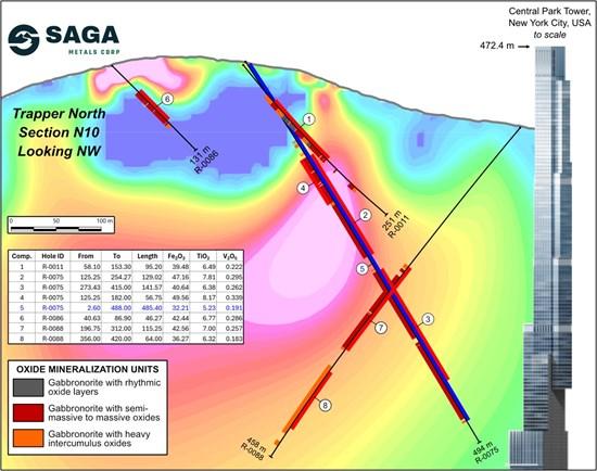
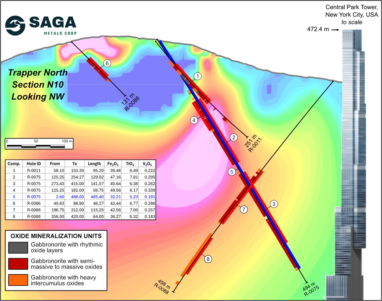
Figure 3: Cross section of N10 looking NW showing R-0011, R-0075, R-0086 and R-0088, highlighting intercepts of semi-massive oxides and layering sequence with the 3D Magnetic Inversion of the 2025 Trapper Zone ground magnetic survey. Assays shown for R-0011, R-0075, R-0086, and R-0088 Central Park Tower located in Manhattan, New York, the world’s largest residential building1 at 472.4 m, is used to contextualize the size of drill hole R-0075 and the significance of the 485.4 m (1,592.5 feet) intercept (highlighted in blue) with correlated titanium, vanadium and iron.
To view an enhanced version of this graphic, please visit:
https://images.newsfilecorp.com/files/12336/318858_sagathree.jpg
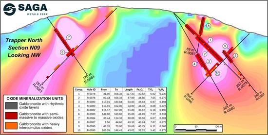
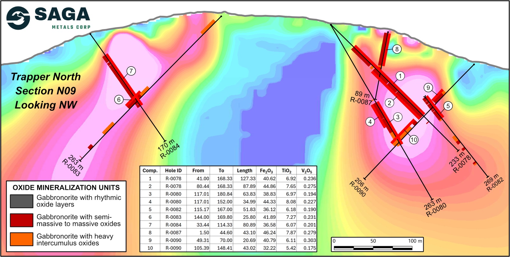
Figure 4: Cross section of N09 looking NW showing R-0078, R-0080, R-0082, R-0083, R-0084, R-0087 and R-0090 highlighting intercepts of semi-massive oxides and layering sequence with the 3D Magnetic Inversion of the 2025 Trapper Zone ground magnetic survey. Assays shown for R-0078, R-0080, R-0082, R-0083, R-0084, R-0087, and R-0090.
To view an enhanced version of this graphic, please visit:
https://images.newsfilecorp.com/files/12336/318858_sagafour.jpg
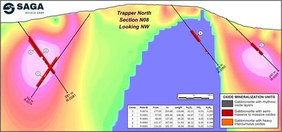
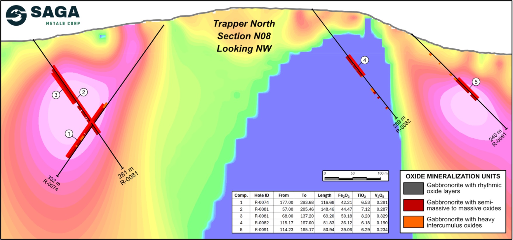
Figure 5: Cross section of N08 looking NW showing R-0074, R-0081, R-0082, and R-0091 highlighting an intercept of layering sequence with the 3D Magnetic Inversion of the 2025 Trapper Zone ground magnetic survey. Assays shown for R-0074, R-0081, R-0082, and R-0091.
To view an enhanced version of this graphic, please visit:
https://images.newsfilecorp.com/files/12336/318858_sagafive.jpg
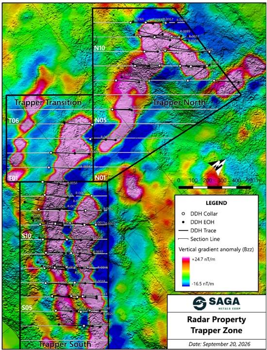
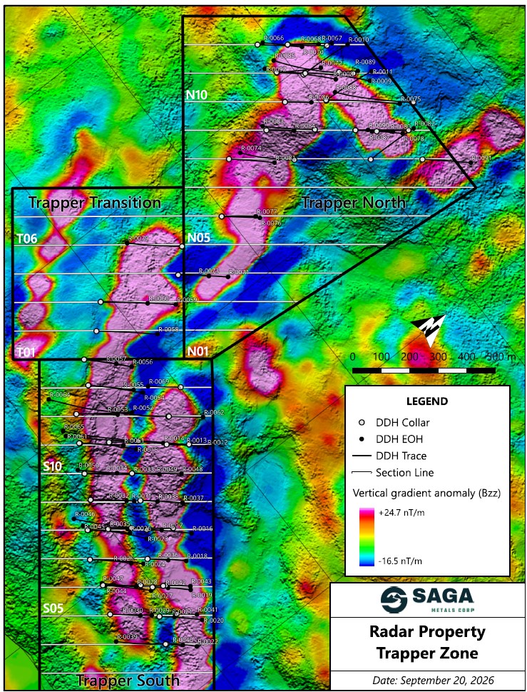
Figure 6: Trapper Zone plan view map outlining location of the MRE diamond drill program completed in August 2026, includes cross-sections S04-S13 in Trapper South, T01-T06 in Trapper Transition, and N6-N12 in Trapper North showing the TMI of the 2025 Trapper Zone ground magnetic survey.
To view an enhanced version of this graphic, please visit:
https://images.newsfilecorp.com/files/12336/318858_0ec3183e34e0d989_006full.jpg
Trapper Zone Assay Highlights
These results now bring the total MRE drill results to a conclusion with all eighty-five (85) diamond drill holes received. The top 25 analytical results from the eighty-five (85) diamond drill holes (Table 1) of the MRE drill program are recapped below:
269152170131
| DDH | FROM | TO | Length | True Thickness | Fe2O3 | TiO2 | V205 | ||
| ID | m | m | m | m | % | % | % | ||
| R-0009 | 94.0 | 181.2 | 87.2 | 84.4 | 50.67 | 10.15 | 0.339 | ||
| R-0008 | 170.0 | 237.6 | 68.3 | 66.2 | 46.15 | 9.21 | 0.311 | ||
| R-0009 | 2.5 | 66.0 | 63.5 | 61.4 | 44. | .02 | 0.254 | ||
| R-0092 | 3.9 | 47.9 | 44.0 | 40.9 | 54.11 | 8.99 | 0.369 | ||
| R-0046 | 20.0 | 74.0 | 54.0 | 43.7 | 58.33 | 8.78 | 0.415 | ||
| R-0077 | 131.0 | 143.1 | 12.1 | 11.4 | 36.69 | 8.76 | 0.182 | ||
| R-0009 | 196.1 | 216.4 | 20.3 | 19.6 | 49.12 | 8.67 | 0.368 | ||
| R-0085 | 264.8 | 333.0 | 68.2 | 62. | .95 | 8.57 | 0.381 | ||
| R-0072 | 360.0 | 429.2 | 69.2 | 49.0 | 51.03 | 8.55 | 0.334 | ||
| R-0008 | 37.8 | 117.7 | 80.0 | 77.5 | 45.63 | 8.40 | 0.335 | ||
| R-0085 | 10.1 | 25.0 | 14.9 | 13.6 | 52.75 | 8.35 | 0.437 | ||
| R-0089 | 3.8 | 35.0 | 31.3 | 15.6 | 51.17 | 8.28 | 0.357 | ||
| R-0057 | 136.9 | 156.5 | 19.6 | 17.0 | 53.72 | 8.24 | 0.377 | ||
| R-0081 | 68.0 | 137.2 | 69.2 | 59.0 | 50.18 | 8.20 | 0.329 | ||
| R-0075 | 125.3 | 182.0 | 56.8 | 44.6 | 49.56 | 8. | .339 | ||
| R-0080 | 117.0 | 152.0 | 35.0 | 24.9 | 44.33 | 8.08 | 0.227 | ||
| R-0072 | 265.5 | 332.3 | 66.8 | 47.3 | 50.06 | 8.07 | 0.349 | ||
| R-0040 | 84.9 | 130.0 | 45. | .9 | 51.20 | 7.94 | 0.340 | ||
| R-0010 | 1.5 | 137.0 | 135.5 | 121.7 | 50.03 | 7.87 | 0.352 | ||
| R-0087 | 1.5 | 44.6 | 43.1 | 42.4 | 46.24 | 7.87 | 0.279 | ||
| R-0075 | 125.3 | 254.3 | 129.1 | 101.4 | 47.16 | 7.82 | 0.295 | ||
| R-0051 | 137.1 | 169.0 | 31.9 | 20.8 | 53.07 | 7.68 | 0.384 | ||
| R-0039 | 97.0 | 149.1 | 52.1 | 50.4 | 58.15 | 7.68 | 0.459 | ||
| R-0078 | 80.4 | 168.3 | 87.9 | 82.1 | 44.87 | 7.65 | 0.275 | ||
| R-0089 | 63.0 | 113.0 | 50.0 | 24.9 | 50.49 | 7.62 | 0.407 |
Table 1: Top 15 intervals from the 2025 & 2026 drilling programs at the Trapper Zone.
Trapper Zone Drilling Summary
The following table presents the true width of oxide mineralization (Table 2) that will be imported into Industry-standard software programs used to develop a mineral resource estimate.
311488275332164245
| Drill Hole | Azimuth / Dip |
Total Depth (m) |
From (metres) | To (metres) | Semi-Massive Oxide (m) |
Rhythmic Layering (m) |
Total Oxide (m) | True Thickness (m) |
Assays Received |
||||
| R-0008 | 38° / -45° | 272 | 37.74 | 268.57 | 118.49 | 65.7 | 184.19 | 178.6 | Yes | ||||
| R-0009 | 38° / -45° | 299 | 2.53 | 288.5 | 165.89 | 88.22 | 254.11 | 245.9 | Yes | ||||
| R-0010 | 0° / -45° | 251 | 1.5 | 165.67 | 134.26 | 12.33 | 146.59 | 131.6 | Yes | ||||
| R-0011 | 0° / -45° | 251 | 46.46 | 205 | 51.62 | 38.1 | 89.72 | 47.9 | Yes | ||||
| R-0012 | 38° / -45° | 194 | 3.9 | 80. | 15 | 2 | .7 | 73.55 | 76.25 | 40.1 | Yes | ||
| R-0013 | 38° / -45° | 251 | 9.5 | 184.37 | 0 | 174.87 | 174.87 | 153.5 | Yes | ||||
| R-0014 | 38° / -45° | 272 | 8.8 | 106 | 0 | 69.74 | 69.74 | 25.2 | Yes | ||||
| R-0015 | 38° / -45° | 263 | 77 | 232.1 | 5.46 | 140.64 | 146.1 | 129.0 | Yes | ||||
| R-0016 | 38° / -45° | 206 | 44.0 | 102.0 | 45.8 | 12.2 | 58.0 | 53.9 | Yes | ||||
| R-0017 | 38° / -70° | 161 | 50.6 | 140.6 | 87.1 | 3.0 | 90.1 | 73.0 | Yes | ||||
| R-0018 | 38° / -45° | 188 | 44.7 | 156.4 | 65.0 | 46.6 | 111.7 | 70.1 | Yes | ||||
| R-0019 | 38° / -45° | 182 | 66.6 | 133.0 | 38.0 | 28.5 | 66.5 | 72.8 | Yes | ||||
| R-0020 | 38° / -45° | 206 | 50.8 | 138.0 | 28.5 | 58.7 | 87.2 | 66.7 | Yes | ||||
| R-0021 | 38° / -70° | 152 | 81.3 | 127.4 | 33.5 | 12.6 | 46.1 | 24.3 | Yes | ||||
| R-0022 | 38° / -45° | 149 | 22.5 | 118.7 | 31.6 | 59.7 | 91.3 | 85.3 | Yes | ||||
| R-0023 | 38° / -45° | 272 | 100.5 | 239.3 | 30.6 | 76.4 | 107.1 | 67.2 | Yes | ||||
| R-0024 | 38° / -45° | 248 | 108.9 | 219.8 | 46.8 | 62.1 | 108.9 | 68.5 | Yes | ||||
| R-0025 | 38° / -60° | 275 | 123.0 | 253.6 | 6.9 | 118.1 | 125.0 | 89.6 | Yes | ||||
| R-0026 | 38° / -60° | 302 | 108.8 | 273.7 | 16.2 | 138.6 | 154.8 | 87.4 | Yes | ||||
| R-0027 | 38° / -45° | 221 | 81.3 | 175.3 | 34.2 | 59.9 | 94.1 | 73.9 | Yes | ||||
| R-0028 | 38° / -60° | 230 | 105.1 | 215.9 | 22.5 | 87.1 | 109.6 | 57.4 | Yes | ||||
| R-0029 | 38° / -45° | 214 | 65.2 | 184.0 | 13.4 | 105.4 | 118.8 | 106.2 | Yes | ||||
| R-0030 | 38° / -60° | 209 | 83.1 | 189.2 | 25.4 | 79.6 | 105.0 | 57.8 | Yes | ||||
| R-0031 | 38° / -45° | 215 | 63.4 | 171.6 | 2.4 | 105.9 | 108.3 | 87.2 | Yes | ||||
| R-0032 | 38° / -60° | 263 | 53.8 | 214.7 | 18.5 | 136.0 | 154.4 | 145.0 | Yes | ||||
| R-0033 | 38° / -45° | 251 | 67.7 | 203.5 | 23.7 | 112.4 | 136.1 | 104.8 | Yes | ||||
| R-0034 | 38° / -60° | 230 | 48.7 | 214.1 | 66.1 | 93.5 | 159.7 | 156.9 | Yes | ||||
| R-0035 | 38° / -45° | 97 | 8.5 | 66.3 | 0.0 | 35.0 | 35.0 | 25.7 | Yes | ||||
| R-0036 | 38° / -70° | 209 | 47.4 | 128.0 | 68.0 | 8.6 | 76.6 | 38.3 | Yes | ||||
| R-0037 | 38° / -45° | 206 | 42.6 | 146.0 | 50.8 | 52.6 | 103.4 | 85.2 | Yes | ||||
| R-0038 | 38° / -70° | 182 | 45.4 | 146.2 | 55.9 | 45.0 | 100.9 | 73.7 | Yes | ||||
| R-0039 | 218° / -45° | 251 | 84.0 | 196.3 | 82.2 | 23.3 | 105.5 | 102.1 | Yes | ||||
| R-0040 | 38° / -70° | 170 | 38.3 | 130.0 | 44.7 | 28.7 | 73.4 | 34.3 | Yes | ||||
| R-0041 | 38° / -45° | 100 | 6.6 | 84.2 | 38.5 | 30.9 | 69.4 | 52.1 | Yes | ||||
| R-0042 | 38° / -70° | 160 | 88.6 | 137.4 | 26.6 | 10.0 | 36.6 | 24.5 | Yes | ||||
| R-0043 | 38° / -45° | 122 | 28.4 | 101.6 | 37.5 | 35.7 | 73.3 | 55.9 | Yes | ||||
| R-0044 | 218° / -45° | 176 | 82.9 | 105.8 | 19.3 | 3.7 | 22.9 | 16.6 | Yes | ||||
| R-0045 | 218° / -45° | 245 | 39.3 | 223.6 | 67.4 | 71.7 | 139.1 | 96.9 | Yes | ||||
| R-0046 a | 218° / -45° | 491 | 7.4 | 147.9 | 121.7 | 19.3 | 141.0 | 108.0 | Yes | ||||
| R-0046 b | 237.7 | 445.9 | 21.4 | 176.7 | 198.2 | 113.7 | Yes | ||||||
| R-0047 | 218° / -45° | 305 | 106.1 | 247.4 | 50.8 | 71.5 | 122.3 | 118.1 | Yes | ||||
| R-0048 | 38° / -45° | 242 | 31.7 | 149. | .8 | 105.1 | 116.9 | 109.9 | Yes | ||||
| R-0049 | 38° / -60° | 200 | 30.7 | 134.3 | 17.4 | 86.1 | 103.6 | 66.6 | Yes | ||||
| R-0050 | 218° / -45° | 269 | 63.9 | 245.6 | 51.9 | 94.2 | 146.1 | 103.3 | Yes | ||||
| R-0051 | 38° / -60° | 311 | 99.9 | 227.3 | 38.5 | 88.8 | 127.4 | 83.0 | Yes | ||||
| R-0052 | 38° / -45° | 275 | 68.6 | 235.0 | 19.8 | 140.8 | 160.6 | 134.7 | Yes | ||||
| R-0053 | 38° / -60° | 299 | 77.1 | 279.4 | 35.0 | 167.3 | 202.3 | 132.1 | Yes | ||||
| R-0054 | 38° / -45° | 269 | 18.4 | 202.0 | 35.2 | 85.3 | 120.5 | 97.7 | Yes | ||||
| R-0055 | 38° / -60° | 320 | 70.1 | 291.6 | 67.6 | 73.2 | 140.8 | 82.3 | Yes | ||||
| R-0056 | 38° / -45° | 239 | 84.8 | 220.0 | 24.4 | 69.6 | 94.0 | 56.1 | Yes | ||||
| R-0057 | 38° / -60° | 233 | 92.4 | 194.1 | 43.6 | 52.5 | 96.1 | 83.4 | Yes | ||||
| R-0058 | 38° / -45° | 299 | 71.6 | 138.9 | 0.0 | 53.0 | 53.0 | 36.2 | Yes | ||||
| R-0059 | 38° / -45° | 377 | 81.9 | 374.9 | 6.2 | 179.6 | 185.7 | 155.2 | Yes | ||||
| R-0060 | 38° / -60° | 335 | 80.9 | 243. | .9 | 72.0 | 160.9 | 151.5 | Yes | ||||
| R-0061 | 218° / -45° | 359 | 51.9 | 307.3 | 93.5 | 150.8 | 244.4 | 221.2 | Yes | ||||
| R-0062 | 38° / -60° | 251 | 0.0 | 125.6 | 36. | .2 | 111.4 | 101.8 | Yes | ||||
| R-0063 | 180° / -45° | 542 | 61.7 | 494.0 | 6.5 | 131.3 | 137.8 | 79.0 | Yes | ||||
| R-0064 | 218° / -45° | 569 | 2.0 | 492.5 | 160.1 | 236.5 | 396.6 | 340.0 | Yes | ||||
| R-0065a | 218° / -45° | 584 | 41.1 | 162.7 | 4.2 | 117.4 | 121.7 | 117.6 | Yes | ||||
| R-0065b | 338.7 | 584.0 | 61.3 | 172.1 | 233.4 | 191.2 | Yes | ||||||
| R-0066a | 218° / -45° | 320 | 52.2 | 98.5 | 32.1 | 0.0 | 32.1 | 32.1 | Yes | ||||
| R-0066b | 169.7 | 298.9 | 0.0 | 93.7 | 93.7 | 93.3 | Yes | ||||||
| R-0067a | 38° / -45° | 203 | 13.8 | 33.0 | 0.0 | 19.2 | 19.2 | 18.2 | Yes | ||||
| R-0067b | 48.5 | 124.3 | 19.2 | 55.6 | 74.8 | 71.1 | Yes | ||||||
| R-0068 | 38° / -65° | 263 | 31.5 | 72.2 | 24.6 | 9.9 | 34.6 | 17.6 | Yes | ||||
| R-0069 | 218° / -60° | 221 | 105.7 | 122.2 | 0.0 | 16.5 | 16.5 | 10.6 | Yes | ||||
| R-0070 | 38° / -45° | 221 | 36.0 | 42.6 | 0.0 | 6.6 | 6.6 | 6.5 | Yes | ||||
| R-0071 | 38° / -45° | 242 | 59.4 | 186.6 | 46.4 | 55.2 | 101.6 | 78.9 | Yes | ||||
| R-0072 | 38° / -70° | 473 | 51.8 | 437.2 | 255.9 | 86.2 | 342.1 | 241.9 | Yes | ||||
| R-0073 | 38° / -65° | 254 | 46.0 | 208.3 | 58.6 | 51.3 | 109.9 | 97.9 | Yes | ||||
| R-0074 | 218° / -55° | 332 | 172.0 | 293.7 | 97.2 | 23.5 | 120.7 | 100.2 | Yes | ||||
| R-0075 | 38° / -55° | 488 | 103.1 | 467.1 | 304.7 | 15.2 | 319.9 | 251.3 | Yes | ||||
| R-0076 | 38° / -45° | 188 | 46.1 | 89. | .9 | 10.3 | 43.2 | 38.4 | Yes | ||||
| R-0077 | 38° / -65° | 281 | 61.3 | 254.6 | 45.7 | 50.1 | 95.9 | 90.5 | Yes | ||||
| R-0078 | 38° / -45° | 233 | 41.0 | 179.5 | 119.6 | 3.3 | 122.8 | 115.2 | Yes | ||||
| R-0079 | 218° / -40° | 251 | 67.4 | 210.9 | 59.5 | 65.7 | 125.2 | 115.1 | Yes | ||||
| R-0080 | 38° / -60° | 263 | 111.7 | 180.8 | 43.6 | 21. | .7 | 46.0 | Yes | ||||
| R-0081 | 38° / -55° | 278 | 62.9 | 205.5 | 130.5 | 0.0 | 130.5 | 111.3 | Yes | ||||
| R-0082 | 0° / -45° | 269 | 115.2 | 245.0 | 57.4 | 12.3 | 69.6 | 58.4 | Yes | ||||
| R-0083 | 218° / -45° | 263 | 10.0 | 259.0 | 29.6 | 58.0 | 87.6 | 76.0 | Yes | ||||
| R-0084 | 38° / -55° | 164 | 33.4 | 114.3 | 79.1 | 0.0 | 79.1 | 64.5 | Yes | ||||
| R-0085 | 218° / -55° | 503 | 10.1 | 503.0 | 275.6 | 132.9 | 408.5 | 284.2 | Yes | ||||
| R-0086 | 38° / -45° | 131 | 40.6 | 93.8 | 45.0 | 3.6 | 48.6 | 47.8 | Yes | ||||
| R-0087 | 218° / 80° | 89 | 1.5 | 56.9 | 53.0 | 2.4 | 55.4 | 45.3 | Yes | ||||
| R-0088 | 218° / -50° | 458 | 196.8 | 444.1 | 99.6 | 104.0 | 203.6 | 161.6 | Yes | ||||
| R-0089 | 38° / -80° | 470 | 3.8 | 443.7 | 127.0 | 197.9 | 324.8 | 161.9 | Yes | ||||
| R-0090 | 218° / -45° | 206 | 51.7 | 148.4 | 21.0 | 36.4 | 57.4 | 50.3 | Yes | ||||
| R-0091 | 38° / -45° | 233 | 46.4 | 165. | .8 | 16.7 | 62.4 | 56.1 | Yes | ||||
| R-0092 | 218° / -50° | 221 | 3.9 | 192.8 | 134.4 | 26.2 | 160.6 | 149.3 | Yes | ||||
| Total (m) | 20,379 |
Table 2: Summary of drill holes R-0008 to R-0092, highlighting the oxide intercepts. See Figures 2, 3, 4, & 5 above, which depict the oxide mineralization in cross sections N11, N10, N09, & N08. True thickness represents the perpendicular width of the mineralized zone, while the total downhole oxide represents the length of the mineralization intercepted downhole.
About the Radar Critical Mineral Property in Labrador
The Radar Property comprises 690 mineral claims across 9 mineral licenses, totalling approximately 24,175 hectares in southeastern Labrador, located approximately 10 km south of Cartwright. The Property entirely encloses the Dykes River Intrusive Complex (~160 km² at the surface) and is accessible year-round via paved Route 510, a Cartwright logging road, and a SAGA-constructed access trail. Infrastructure advantages include the deep-water port at Cartwright, the Cartwright Airport (YRF), and proximity to regional hydroelectric power from Muskrat Falls and Churchill Falls.
Diamond drilling, geophysics, trenching and geological mapping have confirmed a 29 km2 oxide-bearing lopolith that host the Trapper, Falcon and Hawkeye Zones. VTM mineralization at Radar is comparable to that of global Fe-Ti-V systems such as Panzhihua (China) and Bushveld (South Africa). Subject to further exploration, resource definition, and metallurgical testing, the Project may represent a strategic source of titanium, vanadium, and iron for North American markets.
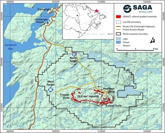
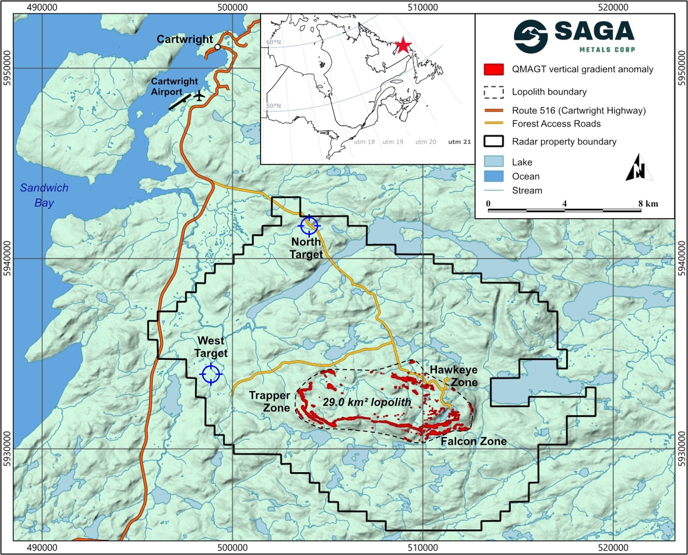
Figure 7: The Radar Property with the Dias QMAGT vertical gradient (Bzz) anomaly footprint shown in red (high-amplitude pixels only). The QMAGT-imaged central oxide-layering lopolith validated over a 29 km2 area, encompassing the Trapper Zone, Hawkeye Zone, and the new Falcon Zone, with additional targets highlighted to the west and north. The Property is well serviced by road access and is conveniently located near the town of Cartwright, Labrador.
To view an enhanced version of this graphic, please visit:
https://images.newsfilecorp.com/files/12336/318858_sagaseven.jpg
Source:
Qualified Person
Dr. A. Miller, P. Geo., PEGNL, is an Independent Qualified Person as defined under National Instrument 43-101 and has reviewed and approved the technical information disclosed in this news release.
Technical Information
Diamond drill core was logged and sampled by Company personnel at SAGA’s core facility in Cartwright, Labrador. The drill core diameter was NQ. The core was cut lengthwise using a diamond saw, and one half was retained in the core box, while the other half was sampled at designated intervals for analysis.
Core samples were prepared and analyzed at the Impact Global Solutions laboratory facility in Montréal, Québec. As part of the analytical quality assurance and quality control program, certified reference standards, blanks, and duplicate samples were inserted into the sample stream at regular intervals to monitor analytical accuracy and precision.
Crush rejects and pulp samples are retained and stored in a secure facility for potential future verification and re-analysis. The Company maintains a rigorous QA/QC protocol consistent with industry standard practices.
About SAGA Metals Corp.
SAGA Metals Corp. is a North American mining company focused on the exploration and discovery of a diversified suite of critical minerals that support the North American transition to supply security. The 100% owned Radar Ti-V-Fe Project comprises 24,175 hectares and entirely encloses the Dykes River intrusive complex, mapped at 160 km² on the surface near Cartwright, Labrador. Exploration to date, including 24,641 m of drilling in the Hawkeye and Trapper zones, has confirmed a large, mineralized layered mafic intrusion hosting vanadiferous titanomagnetite and ilmenite mineralization with consistently uniform grades of titanium, vanadium and iron.
The 100% owned Wolverine Heavy Rare Earth Element Project in Labrador, is a near-surface REE system hosted within peralkaline volcanic rocks that shares geological similarities with the intrusion-hosted Tanbreez, Strange Lake deposits and the stratiform Brockman (Hastings) REE deposit, Western Australia. Historic drilling identified consistent mineralization with assays up to 2.03% TREO including approximately 28% HREO. Large scale potential is supported by 26 km2 of exposed mineralization tuff at surface with about 5% of the prospective unit drilled to date. In addition, grab sample assays of pegmatite hosted in peralkaline granite returned up to 21.6% TREO.
The 100% owned Double Mer Uranium Project covers 25,600 hectares and features uranium radiometrics that highlight an 18 km east-west trend, with a confirmed 14 km section producing samples as high as 0.428% U3O8. (2024 Double Mer Technical Report).
Additionally, SAGA owns the Legacy Lithium Project in Quebec’s Eeyou Istchee James Bay region. This project spans 72,701 hectares and has geological attributes similar to nearby terrains currently being explored by Rio Tinto, Li-FT Power, SOQUEM, and Loyal Metals.
With a portfolio spanning key commodities critical to the clean energy future, SAGA is strategically positioned to play an essential role in securing critical minerals.
On Behalf of the Board of Directors
Mike Stier, Chief Executive Officer
For more information, contact:
Rob Guzman, Investor Relations
SAGA Metals Corp.
Tel: +1 (844) 724-2638
Email: rob@sagametals.com
www.sagametals.com
Brutus Mining Inc. (CSE: BRU) (FSE: ZI3) is pleased to announce that it has closed its non-brokered ... READ MORE
Jaguar Uranium Corp. (NYSE American: JAGU) is pleased to announce an independent Mineral Resource E... READ MORE
Auro Metals Inc. (TSX-V: AURO) (OTCQB: AURFF), is pleased to announce the assay results of the fina... READ MORE
Endeavour Silver Corp. (NYSE: EXK) (TSX: EDR) is pleased to announce that repairs to the primary bal... READ MORE
Scorpio Gold Corp. (NASDAQ: SGLD) (TSX-V: SGLD) (OTCQB: SRCRF) (FSE: RY9) is pleased to announce re... READ MORE