








District-wide 65-hole drill program identifies multiple VMS-style, intrusion-related gold and structurally controlled gold systems along 17-km Winnie Lake Stock corridor
Kirkland Lake Discoveries Corp. (TSX-V: KLDC) (OTCQB: KLKLF) announces receipt of the complete gold and multi-element analytical dataset from the KL West diamond drilling campaign completed on April 1, 2026. The program comprised 65 drill holes totalling 19,161.9 m and 9,616 original drill-core samples.
Integration of the analytical data with geological logging, alteration, mineralization, structural interpretation and regional geophysics has identified multiple fertile hydrothermal systems and established a district-scale framework for vectoring toward higher-priority discovery opportunities.
Highlights
The importance of this program extends well beyond any single drill intersection,” said Stefan Sklepowicz, Chief Executive Officer of KLDC. “Our regional targets repeatedly intersected the same fertile hydrothermal signatures along kilometre-scale corridors, giving us a much clearer understanding of the mineralizing system across the property. We can now see where the system is distal, where it becomes more focused and where gold, copper and critical-metal associations coincide. This property-wide understanding provides a more predictive framework for ranking our next generation of drill targets and reinforces the potential for multiple discoveries across KL West.”
Exploration Model Update
KLDC is actively incorporating the final analytical results into QGIS and Leapfrog workflows. The next phase of work will focus on:
What 19,000 Metres of Drilling Achieved
The completed program has converted a collection of largely independent targets into a property-scale exploration framework. KL West can now be evaluated as a district-scale project with multiple independently testable discovery opportunities.
Table 1 – From Scattered Targets to a District-Scale Story
| Exploration question | Before the program | Today |
| District controls | Limited understanding of property-scale controls | Three recurring mineral-system signatures recognized |
| Target context | Targets evaluated largely in isolation | Ten target areas assessed within one regional framework |
| Mineralized footprint | Individual occurrences and anomalies | Multiple hydrothermal and mineralized corridors identified |
| Predictive model | No property-wide vectoring model | Integrated property-scale vectoring framework established |
| Follow-up focus | Broad regional target testing | Several priority targets advanced toward focused follow-up drilling |
Mineralization Systems at KL West
Integrated interpretation indicates that KL West hosts at least three distinct mineralizing environments.
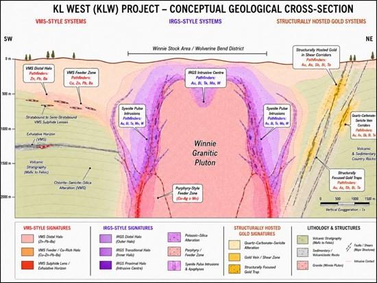
Figure 1 – Conceptual illustration of how multi-element assemblages and alteration are used to distinguish distal, transitional and proximal portions of the KL West hydrothermal systems.
Gold Mineralization Across Multiple Target Areas
Gold mineralization is distributed across both the initial 2025 discovery holes and the broader 2026 regional campaign. The final database includes newly calculated intervals at Winnie Lake, Wolverine Bend and Hammerhead that complement previously released intersections.
Table 2 – Selected gold composite intervals from the KL West database
| Drill Hole | Target | From (m) | To (m) |
Interval (m) | Au (g/t) |
| KLD25-28 | Winnie Lake | 20.00 | 28.20 | 8.20 | 0.312 |
| KLD25-31 | Winnie Lake | 262.00 | 265.75 | 3.75 | 0.435 |
| KLD25-32 | Winnie Lake | 261.00 | 266.00 | 5.00 | 1.475 |
| KLD25-34 | Winnie Lake | 34.74 | 36.15 | 1.41 | 0.612 |
| KLD25-35 | Winnie Lake | 14.62 | 19.64 | 5.02 | 0.479 |
| KLD25-36 | Winnie Lake | 14.20 | 18.90 | 4.70 | 0.621 |
| KLD25-39 | Wolverine Bend | 43.06 | 49.34 | 6.28 | 0.617 |
| KLD25-40 | Wolverine Bend | 24.95 | 33.20 | 8.25 | 0.863 |
| Including | 26.00 | 31.50 | 5.50 | 1.213 | |
| KLD26-48 | Winnie Lake | 259.67 | 262.90 | 3.23 | 1.580 |
| Including | 259.67 | 262.42 | 2.75 | 1.770 | |
| KLD26-52 | Winnie Lake | 261.00 | 262.13 | 1.13 | 5.570 |
| KLD26-55 | Winnie Lake | 60.80 | 63.63 | 2.83 | 0.389 |
| KLD26-62 | Wolverine Bend | 201.20 | 202.00 | 0.80 | 1.865 |
| KLD26-62 | Wolverine Bend | 217.00 | 226.00 | 9.00 | 0.217 |
| KLD26-68 | Wolverine Bend | 271.15 | 271.94 | 0.79 | 1.885 |
| KLD26-72 | Hammerhead | 195.45 | 200.49 | 5.04 | 0.251 |
| KLD26-73 | Wolverine Bend | 222.88 | 227.00 | 4.12 | 0.596 |
| KLD26-77 | Wolverine Bend | 16.50 | 17.22 | 0.72 | 2.090 |
| KLD26-79 | Wolverine Bend | 242.40 | 245.80 | 3.40 | 1.410 |
| KLD26-81 | Wolverine Bend | 81.00 | 82.00 | 1.00 | 1.190 |
New composites use a 0.20 g/t Au cut-off, up to 3.0 m of consecutive internal dilution, length-weighted averages and no top cut. Previously released intervals are reproduced as originally reported and may reflect their original reporting parameters. Intervals are core lengths; true widths are not known for all regional targets.
Priority Growth Targets
Review of the complete dataset has identified several areas for increased technical focus.
Winnie Lake remains the most advanced target area at KL West and continues to demonstrate the scale, geological complexity and overlapping signatures expected in an evolving hydrothermal system.
Wolverine Bend is a significant follow-up target generated by the regional campaign and provides a clear opportunity to test the continuity and geometry of the broader gold-related alteration corridor.
Future drilling can test whether this area represents an intrusive source or fluid-focus centre related to mineralized corridors elsewhere at KL West.
Data Verification and Quality Assurance/Quality Control
The drill-hole database contains 9,616 original drill-core samples with final gold and multi-element analytical results. True widths are estimated at approximately 65% to 80% of reported core-length intervals where sufficient geological information is available. Assays are reported uncut except where otherwise indicated.
All NQ drill-core samples were submitted to ALS Laboratories in Ontario, Québec and British Columbia. Gold analyses used industry-standard 50 g fire-assay methods with an atomic-absorption finish, including Au-AA24. Selected samples were re-analyzed gravimetrically where warranted. Multi-element geochemistry used four-acid digestion followed by ICP-AES and ICP-MS determination, including ME-MS61; ore-grade overlimits used methods including Cu-OG62 and Zn-OG62.
Selected intervals were screened by portable X-ray fluorescence for rapid multi-element interpretation. These results are semi-quantitative and are not used to report compliant laboratory assays. Drill core was cut by diamond saw; half was retained for reference and half submitted for analysis.
Program design, QA/QC and interpretation were conducted by qualified persons using procedures consistent with National Instrument 43-101 and industry best practices. Certified reference materials and blanks were inserted at approximately one control sample per 20 samples. ALS also maintains an internal program of reference materials, blanks and duplicate analyses. KLDC reviews analytical certificates and control-sample performance before accepting results into the final ranked database.
Qualified Person
The technical information in this news release has been reviewed and approved by Benjamin Cleland, P.Geo., Vice-President Exploration, a Qualified Person as defined by National Instrument 43-101 – Standards of Disclosure for Mineral Projects.
About Kirkland Lake Discoveries Corp.
Kirkland Lake Discoveries Corp. has assembled a 420-km² exploration portfolio in the Kirkland Lake region of Ontario’s Abitibi Greenstone Belt, one of the world’s most prolific mining districts. The Company’s properties span key fault zones, geophysical anomalies and volcanic-sedimentary contacts within the Blake River Group, a highly prospective assemblage known to host gold and polymetallic massive-sulphide deposits.
With exploration permits in place, KLDC is positioned to advance a pipeline of drill-ready targets at KL South, KL West and KL East, supported by anomalous soil trends, historical mineral showings, geological interpretation and geophysical datasets.
Brutus Mining Inc. (CSE: BRU) (FSE: ZI3) is pleased to announce that it has closed its non-brokered ... READ MORE
Jaguar Uranium Corp. (NYSE American: JAGU) is pleased to announce an independent Mineral Resource E... READ MORE
Auro Metals Inc. (TSX-V: AURO) (OTCQB: AURFF), is pleased to announce the assay results of the fina... READ MORE
Endeavour Silver Corp. (NYSE: EXK) (TSX: EDR) is pleased to announce that repairs to the primary bal... READ MORE
Scorpio Gold Corp. (NASDAQ: SGLD) (TSX-V: SGLD) (OTCQB: SRCRF) (FSE: RY9) is pleased to announce re... READ MORE


