








Dome1
Drilling continues to intersect excellent grades and widths within and outside Resource pit shell2; Resource update on track for late 2026
TVZ
New intersections indicate strong correlation of mineralized zones and grades with previously drilled holes as well as potential grade upside2: Samples shipped for Metallurgical testing; Initial National Instrument 43-101 Resource estimate expected before year end2
Owl Creek
Continuation of positive drill results; Exploration ramp development underway to accelerate drilling along 1.5 km Hoyle Pond – Owl Creek Trend
Discovery Mining Ltd. (TSX: DSV) (OTCQX: DSVSF) reported results from ongoing exploration at the Company’s advanced stage growth projects, Dome, TVZ and Owl Creek. The results, which include assays from a combined total of 55 holes1 (17,845.5 m) completed between Q4 2025 and Q2 2026, continued to expand mineralization, indicated excellent correlation of widths and grades to previous drilling and clearly demonstrated the upside that exists at all three projects.
Line to 3D Visuals: https://vrify.com/decks/23480?auth=829532ad-ef99-48f1-a3e6-b5e9667f5c44
Tony Makuch, Discovery’s CEO, commented: “The excellent drilling results we are announcing today are extremely encouraging as we work towards releasing NI 43-101 resource estimates at Dome and TVZ before the end of 2026, and further advancing Owl Creek. These are three critical growth projects that, collectively, could contribute between a quarter and half a million ounces of annual gold production. With an existing 11.0 million ounce Inferred Resource, we expect Dome to become our second large-scale, open-pit operation in Timmins, along with Pamour, where recent drill results confirmed a strike length extending more than 4.0 km, with the mineralization remaining open in multiple directions and at depth. TVZ and Owl Creek are part of the Hoyle Pond Complex and both will benefit from our recent acquisition of the Kidd Metallurgical Site, located contiguous to Hoyle Pond and Pamour. Our plan for the Met Site is to construct a new conventional gold circuit that will process material from Pamour, Hoyle Pond, Owl Creek and other potential new sources of production. We also plan to commence processing Borden material using one of the current flotation circuits, likely beginning early next year, and will convert another circuit to gold flotation for future processing of TVZ material, given the refractory nature of the mineralization.
“Looking at today’s results, drilling at Dome continued to intersect excellent grades and widths in the southwest, north and northeast portions of the project, including favourable results from drilling below the north wall of the current resource pit. At TVZ, additional high-grade intersections were reported from drilling on both the 1210 and 1680 levels, with the results demonstrating excellent correlation of mineralized zones and grades with previously drilled holes and also confirming the down plunge potential of the TVZ zone. We also have completed drilling to collect samples for metallurgical testing, with the results expected to be received later this year. Drilling at Owl Creek included additional positive results, with the Company having now commenced work on a 1.5 km underground drift from Hoyle Pond to Owl Creek. Development of the drift will support an acceleration of drilling for additional extensions at Owl Creek and the 750 Zone, and the evaluation of new targets, such as the historic 350 Zone, which is located 500 m to the east of the 750 Zone.”
Dome Mine Project
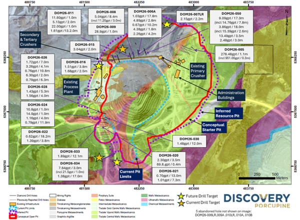
Drilling at Dome included a total of 23 holes (8,391 m) being completed (Figure 1), with 5 holes (451 m) being abandoned due to excessive deviation from the target.
Dome is among the largest historic gold producers in Canada, with total production of 16.7 million ounces from both underground and open pit sources between 1910 and 2017.
Geologically, the mine is located on the south limb of the Porcupine Syncline and is just north of the Destor Porcupine Fault, with mineralization in multiple zones extending from surface to a depth of approximately 1,600 m.
The current mineral resource at Dome includes 222.3 million tonnes with an average grade of 1.49 gpt for a total of 11.0 million ounces in the Inferred category. The resource assumes a large-scale, open-pit concept to expand the historic pit along strike and to depth.
The current drill program is being completed in preparation for a new mineral resource estimate and involves drilling in areas surrounding and below the historic pit. The work program also includes further evaluations of data and mineralization models to upgrade portions of the resource to the Indicated resource category, and to evaluate the potential for future underground mining at Dome.
The new drilling was focused on infilling gaps in information and confirmation of historic drill holes in the southwest, north and northeast portions of the property and continued to obtain highly encouraging results.
Drilling in the southwest portion of the property included nine holes (3,096 m) to evaluate mineralization near the limits of the current resource pit. and continued to indicate excellent grades and widths of mineralization at very shallow depths from surface. Significant results include: 1.89 gpt over 12.1m, in hole DOM26-033; 1.48 gpt over 12.0m, in DOM26-030; 1.38 gpt over 17.0m, in hole DOM26-034; 0.79 gpt over 11.9m, in hole DOM26-024; and 1.72 gpt over 7.0m, 0.76 gpt over 10.8m; 0.79 gpt over 6.0m and, 3.26 gpt over 4.1m, in hole DOM26-026 (Table 1).
Drilling in the north portion of the property included 8 holes (4,349 m) to evaluate the mineralization below the north wall of the resource pit and was also very successful. Significant results include 9.09 gpt over 17.3m including 14.76 gpt over 7.8m, 3.86 gpt over 18.0m including 15.39 gpt over 2.6m, 13.49 gpt over 3.5m in hole DOM26-050; 1.03 gpt over 17.8m, 4.89 gpt over 2.8m and, 2.26 gpt over 4.2m, in hole DOM26-006A; 1.61 gpt over 13.2m and 22.0 gpt over 1.0m in hole DOM26-011; 3.04 gpt over 2.0m in hole DOM26-015; 1.51 gpt over 3.8m in hole DOM26-016 and; 5.04 gpt over 8.4m, including 11.20 gpt over 3.0m, in hole DOM26-008.
Drilling to the northeast included one new hole (495 m) which tested near the northeast limit of the resource pit and intersected a quartz vein structure containing 278.48 gpt over 1.1m, including 951.0 gpt over 0.3m.
Drilling at the project is continuing with two drills, one located in the southwest portion of the historic open pit and the other on the north side. Work is also continuing to evaluate additional drill targets to the north, south and west sides of the pit. Considering results and progress to date, the project remains on track for the planned resource update in late 2026.
Table 1. Intercepts from New Drilling at Dome Project1,2
| Area | Hole ID | Total Hole Depth (m) | From | To | Core length | Au | Notes |
| (m) | (m) | (m) | (g/t) | ||||
| NE/Blueberry | DOM26-005 | 495.0 | 298.8 | 299.9 | 1.1 | 278.48 | In Pit |
| incl | |||||||
| 299.1 | 299.4 | 0.3 | 951.00 | ||||
| Tailings | DOM26-006A | 522.0 | 328.2 | 346.0 | 17.8 | 1.03 | Out |
| 353.0 | 355.8 | 2.8 | 4.89 | Out | |||
| 456.5 | 466.7 | 10.2 | 0.67 | Out | |||
| 471.7 | 473.5 | 1.8 | 4.38 | Out | |||
| 479.0 | 483.2 | 4.2 | 2.26 | Out | |||
| Tailings | DOM26-007LR | 411.0 | 333.8 | 336.0 | 2.2 | 2.15 | Out |
| Tailings | DOM26-008 | 336.0 | 318.3 | 326.7 | 8.4 | 5.04 | Out |
| incl | |||||||
| 323.2 | 326.2 | 3.0 | 11.20 | ||||
| Tailings | DOM26-009 | 691.0 | 690.0 | 691.0 | 1.0 | 28.9 | In Pit |
| Tailings | DOM26-011 | 453.0 | 439.0 | 440.0 | 1.0 | 11.60 | Out |
| 347.0 | 349.0 | 2.0 | 5.13 | Out | |||
| 379.0 | 380.0 | 1.0 | 22.00 | Out | |||
| 470.0 | 474.0 | 4.0 | 1.39 | In Pit | |||
| 493.3 | 506.5 | 13.2 | 1.61 | In Pit | |||
| Tailings | DOM26-015 | 687.0 | 611.0 | 613.0 | 2.0 | 3.04 | Out |
| Tailings | DOM26-016 | 690.0 | 51.2 | 55.0 | 3.8 | 1.51 | In Pit |
| 105.2 | 109.4 | 4.2 | 0.90 | In Pit | |||
| 669.0 | 671.5 | 2.5 | 1.68 | Out | |||
| Tailings | DOM26-050 | 559.0 | 341.0 | 358.3 | 17.3 | 9.09 | Out |
| incl | Out | ||||||
| 342.7 | 350.5 | 7.8 | 14.76 | Out | |||
| 400.0 | 418.0 | 18.0 | 3.86 | Out | |||
| incl | Out | ||||||
| 400.0 | 402.6 | 2.6 | 15.39 | Out | |||
| 445.0 | 448.5 | 3.5 | 13.49 | Out | |||
| 454.0 | 457.0 | 3.0 | 2.48 | Out | |||
| Preston | DOM26-020 | 300.0 | 36.0 | 39.5 | 3.5 | 2.30 | Out |
| 262.4 | 262.8 | 0.4 | 69.8 | Out | |||
| Preston | DOM26-024 | 465.0 | 19.0 | 20.0 | 1.0 | 10.8 | Out |
| 38.0 | 39.0 | 1.0 | 14.9 | Out | |||
| 43.0 | 47.0 | 4.0 | 1.16 | Out | |||
| 147.1 | 159.0 | 11.9 | 0.79 | Out | |||
| Preston | DOM26-021 | 210.0 | 40.6 | 53.6 | 13.0 | 0.70 | Out |
| 187.5 | 194.8 | 7.3 | 1.01 | Out | |||
| Preston | DOM26-022 | 462.0 | 33.5 | 51.7 | 18.2 | 0.62 | Out |
| 155.5 | 159.3 | 3.8 | 1.39 | In Pit | |||
| Preston | DOM26-026 | 612.0 | 8.0 | 15.0 | 7.0 | 1.72 | In Pit |
| 162.4 | 166.5 | 4.1 | 3.26 | In Pit | |||
| 180.0 | 190.8 | 10.8 | 0.76 | Out | |||
| 225.0 | 231.0 | 6.0 | 0.79 | Out | |||
| 283.0 | 285.0 | 2.0 | 6.30 | Out | |||
| 559.3 | 565.6 | 6.3 | 0.79 | Out | |||
| Preston | DOM26-028 | 240.0 | 14.0 | 19.3 | 5.3 | 1.43 | In Pit |
| 66.1 | 70.1 | 4.0 | 1.56 | In Pit | |||
| Preston | DOM26-030 | 375.0 | 156.0 | 168.0 | 12.0 | 1.48 | In Pit |
| Preston | DOM26-033 | 216.0 | 117.0 | 129.1 | 12.1 | 1.89 | Out |
| Preston | DOM26-034 | 216.0 | 64.0 | 67.0 | 3.0 | 7.64 | Out |
| incl | |||||||
| 66.0 | 67.0 | 1.0 | 21.5 | ||||
| 106.0 | 123.0 | 17.0 | 1.38 | Out |
Figure 1. Dome Results
TVZ Project
Drilling at the Hoyle Pond Mine included a total of 22 holes totalling 5,238.5 m (including 1 abandoned hole – 261m) from the 1210 level and 1680 level exploration drifts to confirm and expand the TVZ Zone.
TVZ is a significant zone of gold mineralization located between the 800 and 1800 m levels in the southeast portion of the Hoyle Pond Mine (Figures 2 and 3).
Past work at the project includes 437 holes (172,319 m) of wide-spaced drilling from three main platforms on the 900, 1210 and 1410 levels, as well as limited development, mapping, chip sampling and metallurgical test work on the 1210 level. Results from the drilling, mapping and chip sampling have been positive and indicate multiple holes with grades exceeding 5.00 gpt over widths of 5 to 10 m. The results also indicate positive results from the two deepest holes to test the zone to date, holes 21009 and 21094, with returned values of 6.29 gpt over 5.3 m and 4.98 gpt over 4.0 m, respectively, between the 1550 and 1610 levels. As a result, the potential to extend the zone to greater depths is considered excellent.
Results of the past metallurgical work indicate a strong correlation of gold with arsenopyrite and variable recoveries, but with the potential for improvement using enhanced processing.
The current work program is designed to infill and expand the TVZ Zone, with drilling ongoing from the historic drill platforms, in preparation for an initial NI 43-101 mineral resource in late 2026.
Drilling from the 1210 Level includes 19 holes (4,257m) that intersect the target model near the level elevation and extend up to 200 metres above and below it. Selected intervals from these holes have been sampled and submitted to XPS Laboratories in Sudbury, Ontario, for metallurgical testing. Results are expected late 2026.
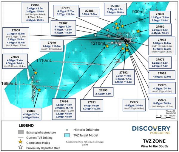
Significant results from holes drilled near the 1210 level include: 5.13 gpt over 18.2m and 5.15gpt over 12.0m, in hole 27967; 7.04 gpt over 16.9m, in hole 27970; 5.17 gpt over 21.0m, in hole 27971; 5.73 gpt over 23.2m, in hole 27972; 6.93gpt over 11.7m and 4.54 gpt over 22.9m, in hole 27974; 5.65 gpt over 30.5m, including 9.05 gpt over 13.2m, in hole 27976; and 4.40 gpt over 14.0m, in hole 27977. Significant results from holes above the level include: 5.84 gpt over 10.6m, in hole 27889 and 5.13 gpt over 5.3m, in hole 27888 and significant results from below the level include: 5.24 gpt over 12.9m, in hole 27891; 3.45 gpt over 15.0m and 4.59 gpt over 25.0m in hole 27969; 2.73 gpt over 19.9m and 4.54 gpt over 18.4m in hole 27968; 3.06 gpt over 15.1m and 6.80gpt over 8.0m in hole 27894; 4.41 gpt over 13.4m in hole 27890 and 5.46 gpt over 12.5m and 4.43 gpt over 4.4m, in hole 27892 (Table 2 and Figure 3). Review of results indicates good correlation of mineralized zones and grades within the new holes and previously drilled holes with local upsides in grade noted due to unsampled core in older holes.
Drilling from the 1680 level includes 2 holes (720.5 m) to continue testing the lower part of the target model which also obtained very favourable results including: 4.51 gpt over 9.0 m, in hole 27849 and; 4.30 gpt over 24.4m, including 5.73 gpt over 12.4m, in hole 27899. The intercept in hole 27899 is located approximately 130 meters above the 1680 level and 40 meters up plunge of previously released hole 27854 which intersected 5.82 gpt over 9.0m and 4.32 gpt over 19.0m, and the intercepts in hole 27849 are located 50 meters below the 1680 level and 30 meters east of hole 27855 which intersected 3.20 gpt over 6.7m, including 5.78 gpt over 2.5m and 15.60 gpt over 0.3m (see press release dated April 23,2026).
Drilling at TVZ is ongoing with two drill rigs operating from the 1210 level and one drill on the 1410 level. Current drilling on the 1210 level is primarily focused on infilling and extending mineralization proximal to historic drill intercepts, while drilling from the 1410 level continues to test the projected down plunge extension of the TVZ Zone.
Table 2: Intercepts from TVZ Project1,2,3
| Level | Hole ID | Total Hole Depth (m) | From | To | Core length | Au | Notes |
| (m) | (m) | (m) | (g/t) | ||||
| 1210L | 27967 | 130.0 | 1.0 | 6.0 | 5.0 | 6.19 | QV/qs/aspy |
| 45.0 | 57.0 | 12.0 | 5.15 | QV/qs/aspy | |||
| 75.4 | 93.6 | 18.2 | 5.13 | QV/qs/aspy | |||
| 27970 | 127.1 | 47.0 | 55.1 | 8.1 | 3.62 | QV/qs/aspy | |
| 77.4 | 94.3 | 16.9 | 7.04 | QV/qs/aspy | |||
| incl | |||||||
| 80.3 | 86.1 | 5.8 | 11.57 | QV/qs/aspy | |||
| 27971 | 130.6 | 19.0 | 37.2 | 18.2 | 1.75 | QV/qs/aspy | |
| 50.0 | 52.7 | 2.7 | 4.51 | QV/qs/aspy | |||
| 73.0 | 94.0 | 21.0 | 5.17 | QV/qs/aspy | |||
| 27972 | 135.0 | 55.0 | 69.0 | 14.0 | 5.39 | QV/qs/aspy | |
| incl | |||||||
| 55.6 | 61.0 | 5.4 | 11.61 | QV/qs/aspy | |||
| 75.8 | 99.0 | 23.2 | 5.73 | QV/qs/aspy | |||
| incl | |||||||
| 86.7 | 99.0 | 12.3 | 8.45 | QV/qs/aspy | |||
| 27973 | 130.7 | 19.0 | 22.5 | 3.5 | 5.24 | QV/qs/aspy | |
| 28.9 | 32.7 | 3.8 | 3.73 | QV/qs/aspy | |||
| 102.1 | 109.6 | 7.5 | 9.01 | QV/qs/aspy | |||
| 27974 | 130.0 | 8.8 | 17.0 | 8.2 | 2.67 | QV/qs/aspy | |
| 73.1 | 96.0 | 22.9 | 4.54 | QV/qs/aspy | |||
| 27975 | 127.0 | 23.0 | 34.6 | 11.6 | 2.75 | QV/qs/aspy | |
| 86.5 | 110.8 | 24.3 | 4.24 | QV/qs/aspy | |||
| incl | |||||||
| 104.0 | 109.3 | 5.3 | 7.07 | QV/qs/aspy | |||
| 27976 | 150.0 | 18.7 | 31.0 | 12.3 | 2.69 | QV/qs/aspy | |
| 105.5 | 136.0 | 30.5 | 5.65 | QV/qs/aspy | |||
| incl | |||||||
| 107.8 | 121.0 | 13.2 | 9.05 | QV/qs/aspy | |||
| 27977 | 170.0 | 0.0 | 6.5 | 6.5 | 3.16 | QV/qs/aspy | |
| 14.6 | 22.9 | 8.3 | 3.35 | QV/qs/aspy | |||
| 112.0 | 126.0 | 14.0 | 4.40 | QV/qs/aspy | |||
| incl | |||||||
| 117.8 | 124.6 | 6.8 | 7.03 | QV/qs/aspy | |||
| 27888 | 342.0 | 101.7 | 105.3 | 3.6 | 5.13 | QV/qs/aspy | |
| 168.5 | 170.6 | 2.1 | 3.29 | QV/qs/aspy | |||
| 229.9 | 233.5 | 3.6 | 3.35 | QV/qs/aspy | |||
| 27890 | 291.0 | 80.2 | 81.0 | 0.8 | 12.85 | QV/qs/aspy | |
| 205.8 | 214.5 | 8.7 | 2.67 | QV/qs/aspy | |||
| 226.0 | 229.6 | 3.6 | 3.26 | QV/qs/aspy | |||
| 27891 | 361.7 | 37.0 | 37.6 | 0.6 | 9.62 | qs/aspy | |
| 258.0 | 270.9 | 12.9 | 5.24 | QV/qs/aspy | |||
| 27892 | 330.0 | 41.0 | 42.0 | 1.0 | 7.21 | qs/aspy | |
| 167.9 | 172.0 | 4.1 | 4.43 | QV/qs/aspy | |||
| 259.5 | 272.0 | 12.5 | 5.46 | QV/qs/aspy | |||
| 27893 | 400.0 | 319.2 | 322.7 | 3.5 | 2.17 | QV/qs/aspy | |
| 27889 | 291.0 | 84.5 | 87.8 | 3.3 | 3.53 | QV/qs/aspy | |
| 105.0 | 106.5 | 1.5 | 7.20 | QV/qs/aspy | |||
| 193.0 | 203.6 | 10.6 | 5.84 | QV/qs/aspy | |||
| 27969 | 150.0 | 2.0 | 4.5 | 2.5 | 5.44 | QV/qs/aspy | |
| 42.0 | 57.0 | 15.0 | 3.45 | QV/qs/aspy | |||
| incl | |||||||
| 43.0 | 47.6 | 4.6 | 5.41 | QV/qs/aspy | |||
| and | |||||||
| 51.6 | 56.4 | 4.8 | 4.77 | QV/qs/aspy | |||
| 89.0 | 114.0 | 25.0 | 4.59 | QV/qs/aspy | |||
| 27968 | 150.0 | 3.3 | 23.2 | 19.9 | 2.73 | QV/qs/aspy | |
| incl | |||||||
| 14.0 | 23.2 | 9.2 | 3.78 | QV/qs/aspy | |||
| 40.0 | 45.5 | 5.5 | 5.45 | QV/qs/aspy | |||
| 108.6 | 127.0 | 18.4 | 4.54 | QV/qs/aspy | |||
| incl | |||||||
| 112.5 | 121.5 | 9.0 | 7.54 | QV/qs/aspy | |||
| 27894 | 400.9 | 57.3 | 58.3 | 1.0 | 7.53 | QV/qs/aspy | |
| 174.5 | 189.6 | 15.1 | 3.06 | QV/qs/aspy | |||
| incl | |||||||
| 183.0 | 186.0 | 3.0 | 7.55 | QV/qs/aspy | |||
| 281.0 | 286.0 | 5.0 | 3.52 | QV/qs/aspy | |||
| 328.0 | 336.0 | 8.0 | 6.80 | QV/qs/aspy | |||
| 27980 | 310.0 | 37.0 | 39.0 | 2.0 | 2.42 | qs/aspy | |
| 204.2 | 208.0 | 3.8 | 3.21 | QV/qs/aspy | |||
| 217.5 | 230.9 | 13.4 | 4.41 | incl 6.9m QV | |||
| 1680L | 27849 | 370.5 | 259.3 | 263.0 | 3.7 | 4.31 | QV/qs/aspy |
| 301.5 | 310.5 | 9.0 | 4.51 | QV/qs/aspy | |||
| 27899 | 350.0 | 259.0 | 261.4 | 2.4 | 4.58 | QV/qs/aspy | |
| 321.0 | 345.4 | 24.4 | 4.30 | QV/qs/aspy | |||
| incl | |||||||
| 333.0 | 345.4 | 12.4 | 5.73 |
Figure 2. TVZ Results (1)
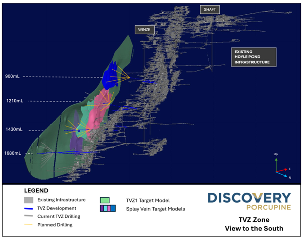
Figure 3: TVZ Results (2)
Owl Creek
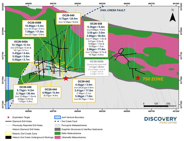
Drilling at the Owl Creek Project included a total of 10 holes (4,216 m) to confirm and expand mineralization near the former Owl Creek open pit (Figure 4). Of the holes drilled, three holes (294 m) were abandoned due to excessive deviation.
The Owl Creek open pit is located approximately 1.5 kilometres west of the Hoyle Pond Ramp Portal and along the south side of the Hoyle Pond belt near the contact between metasedimentary and metavolcanic rocks. The pit, as well as two underground ramps below it, were developed by Falconbridge Gold in the 1980’s and were utilized to recover approximately 237,000 ounces of gold at an average grade of 3.75 gpt.
Significant results include: 7.09 gpt over 17.0m, including 23.12 gpt over 3.9, in hole OC26-036B; 6.35gpt over 9.4m, 2.69 gpt over 30.9m, including 9.31 gpt over 2.0m and, 2.86 gpt over 17.4m, in hole OC26-038; 3.41 gpt over 17.0m, including 7.45 gpt over 3.1m;5.96 gpt over 7.0m in hole OC27-042; 5.73 gpt over 4.2m and 2.74 gpt over 30.4m in hole OC26-046; 4.72 gpt over 24.0m, including 12.26 gpt over 6.8m, in hole OC26-040; 4.86 gpt over 8.4m in hole OC26-044; and 19.35 gpt over 5.4m, including 270.0 gpt over 0.3m in hole OC26-045A (Table 3).
Holes OC26-036B, OC26-038, OC26-040, and OC26-042 were drilled to infill previously untested gaps in the eastern portion of the deposit between the 275 m and 375 m levels. Hole OC26-036B was drilled approximately 335 m below previously released hole OC26-029A, while hole OC26-038 was drilled approximately 135 m below OC26-029A. Hole OC26-040 was drilled approximately 200 m below OC26-029A, and hole OC26-042 was drilled approximately 55 m west of OC26-029A (see press release dated April 23, 2026).
Holes OC26-040, OC26-44, OC26-045A and OC26-046 were drilled to infill untested areas below the historic pit surface between the surface and the 175 m level. Relative to previously released hole OC26-029A, hole OC26-044 was collared approximately 125 m up-dip and 150 m to the west, hole OC26-045A was drilled approximately 125 m up-dip and 225 m to the west, and hole OC26-046 was drilled approximately 125 m up-dip and 275 m to the west.
While the review and interpretation of drilling is still in progress, results to date at both Owl Creek and the 750 Zone are very encouraging. As a result, the Company has initiated a new exploration ramp from the Hoyle Pond Mine to Owl Creek to allow more detailed drilling at Owl Creek, as well as exploration drilling between the two areas. The new exploration ramp will start from the existing surface portal for the Hoyle Pond Mine located, just north of the 350 Zone, and is projected to be approximately 1.5 km in length. The expected completion date for the ramp is in Q3 2027.
The current drill program is continuing with two rigs that will focus on infill and extension of mineralization at both the Owl Creek and the 750 zones. Work is also in progress to review potential new drill targets along the Hoyle Pond – Owl Creek Trend, such as the historic 350 Zone, which is located 500 m to the east of the 750 Zone and is partially developed, with a ramp connecting it to the Hoyle Pond Mine near the main ramp portal.
Table 3. Intercepts from New Drilling at the Owl Creek Project1,2
| Hole ID | Total Hole Depth | From | To | Core length | Au | |
| (m) | (m) | (m) | (g/t) | |||
| OC26-036B | 867 | 594.8 | 597.1 | 2.3 | 10.60 | |
| including | 596.0 | 596.5 | 0.5 | 45.30 | ||
| 769.0 | 786.0 | 17.0 | 7.09 | |||
| including | 782.1 | 786.0 | 3.9 | 23.12 | ||
| 801.1 | 804.2 | 3.1 | 3.20 | |||
| 822.3 | 824.1 | 1.8 | 4.31 | |||
| OC26-038 | 651.0 | 447.6 | 457.0 | 9.4 | 6.35 | |
| including | 448.0 | 453.6 | 5.6 | 9.69 | ||
| 479.0 | 482.0 | 3.0 | 3.59 | |||
| 491.0 | 521.9 | 30.9 | 2.69 | |||
| including | 491.0 | 492.0 | 1.0 | 11.80 | ||
| including | 497.0 | 499.0 | 2.0 | 9.31 | ||
| including | 504.0 | 505.5 | 1.5 | 14.64 | ||
| including | 516.9 | 518.2 | 1.3 | 12.65 | ||
| 534.3 | 551.7 | 17.4 | 2.86 | |||
| including | 535.1 | 535.8 | 0.7 | 12.93 | ||
| including | 546.6 | 547.2 | 0.6 | 14.70 | ||
| OC26-042 | 576.0 | 204.0 | 205.0 | 3.0 | 4.42 | |
| including | 204.0 | 204.4 | 0.4 | 24.20 | ||
| 349.5 | 366.5 | 17.0 | 3.41 | |||
| including | 361.2 | 364.3 | 3.1 | 7.45 | ||
| 403.1 | 410.1 | 7.0 | 5.96 | |||
| including | 408.7 | 409.7 | 1.0 | 28.70 | ||
| OC26-046 | 372.0 | 168.0 | 170.0 | 2.0 | 3.68 | |
| 180.7 | 184.9 | 4.2 | 5.73 | |||
| 243.0 | 273.4 | 30.4 | 2.74 | |||
| including | 243.0 | 244.0 | 1.0 | 10.40 | ||
| including | 260.1 | 263.0 | 2.9 | 4.83 | ||
| including | 270.0 | 273.4 | 3.4 | 7.47 | ||
| OC26-040 | 705.0 | 594.0 | 618.0 | 24.0 | 4.72 | |
| including | 610.0 | 616.8 | 6.8 | 12.26 | ||
| OC26-044 | 408.0 | 202.0 | 210.4 | 8.4 | 4.86 | |
| including | 203.1 | 208.0 | 4.9 | 6.37 | ||
| OC26-045A | 342.0 | 157.9 | 166 | 8.1 | 13.19 | |
| including | 159.4 | 159.7 | 0.3 | 270.00 | ||
| and incl | 161 | 161.7 | 0.7 | 18.70 | ||
| 187.5 | 188.3 | 0.8 | 11.61 | |||
| 207.0 | 211.4 | 4.4 | 3.43 | |||
| 219.0 | 222.0 | 3.0 | 3.55 | |||
| 241.8 | 244.5 | 2.7 | 5.05 |
Figure 4. Owl Creek Plan View
QUALIFIED PERSONS
Discovery’s exploration programs at the Porcupine Operations are conducted under the supervision of Eric Kallio, P.Geo., Senior Vice President, Exploration, Kara Byrnes, P.Geo, Vice President, Exploration and Geology – Porcupine and Craig Yuill, P.Geo., Exploration Manager. Mr. Kallio, Ms. Byrnes and Mr. Yuill are “qualified persons” for the purpose of National Instrument 43-101, Standards of Disclosure for Mineral Projects, of the Canadian Securities Administrators, and have reviewed and approved the scientific and technical information in this news release.
Readers are referred to the mineral resource estimate as set out in the Company’s current technical report entitled “Porcupine Complex, Ontario, Canada NI 43-101 Report on Preliminary Assessment” with an effective date of January 13, 2025, which is available under the Company’s issuer profile on SEDAR+ at www.sedarplus.ca. Statements concerning mineral resource estimates may also be deemed to constitute forward looking information to the extent that they involve estimates of the mineralization that will be encountered if the property is developed. The Technical Report includes the results of a preliminary economic assessment which is preliminary in nature. It includes inferred mineral resources that are considered too speculative geologically to have the economic considerations applied to them that would enable them to be categorized as mineral reserves and there is no certainty that the preliminary economic assessment will be realized.
QA/QC CONTROLS
The Company follows a quality assurance and control program to ensure that sampling and analysis of all exploration work is conducted in accordance with best practices.
At TVZ, core is logged and sampled in a secure facility at the Hoyle Pond mine site and under supervision of Qualified Geologists. The NQ sized drill core is predominantly sawn in half with one half of the core prepared for shipment, the other half of core retained for future assay verification. CRM standards, coarse blank material and duplicates are inserted every 20 samples. Core samples are picked up by Activation Laboratories at the Hoyle Pond facility and tracked via a chain of custody from site to the lab for preparation and assaying.
At Dome, core is logged and sampled in a secure facility at the Dome mine site and under supervision of Qualified Geologists. The NQ sized drill core is predominantly sawn in half with one half of the core prepared for shipment, the other half of core retained for future assay verification. CRM standards, coarse blank material and duplicates are inserted every 20 samples. Core samples are picked up by Activation Laboratories at the Dome Mine core facility and tracked via a chain of custody from site to the lab for preparation and assaying.
At Owl Creek, all new drill core collected by Discovery is logged and sampled in a secure facility at the Hoyle Pond mine site and under supervision of Qualified Geologists. The NQ sized drill core is predominantly sawn in half with one half of the core prepared for shipment, the other half of core retained for future assay verification. CRM standards, coarse blank material and duplicates are inserted every 20 samples. Core samples are picked up by Activation Laboratories at the Hoyle Pond facility and tracked via a chain of custody from site to the lab for preparation and assaying.
Discovery utilizes the accredited external lab Activation Laboratories to manage its core analysis. ActLabs is certified by the Standards Council of Canada which conforms with ASB-RG Mineral Analysis Laboratory for the Accreditation of Mineral Analysis Testing Laboratories and CAN-P-4E ISO/IEC 17025: General Requirements for the Competence of Testing and Calibration Laboratories.
Sample preparation includes crushing drill core up to 80% passing 2 mm, riffle splitting 500 grams and pulverizing to 95% passing 105 µm followed by both scheduled and specifically requested silica sand cleaning. Gold Analysis involves Fire Assay – Atomic Absorption technique from a 50-gram pulp sample with grade ranges between 5 to 10,000 ppb. Samples greater than 10,000 ppb are analyzed with a gravimetric finish. Selected high grade samples are also analyzed using the screen metallics procedure.
ABOUT DISCOVERY
Discovery Mining Ltd. is a growing precious metals company that is creating value for stakeholders through exposure to gold, silver and other critical minerals. Discovery is advancing plans to more than double annual gold production through investment in the Company’s Porcupine assets, which include multiple operations, attractive growth projects and significant exploration upside in one of the world’s most renowned gold camps in and near Timmins, Ontario. The acquisition of the Kidd Operations in June 2026 further increased Discovery’s land position within the camp, provided valuable infrastructure that will support the Company’s growing gold business, and added critical minerals to the Company’s current production profile. Discovery’s silver exposure comes mainly from the 100%-owned Cordero project, one of the world’s largest undeveloped silver deposits, which is located close to infrastructure in a prolific mining belt in Chihuahua State, Mexico.
SAGA Metals Corp. (TSX-V: SAGA) (OTCQX: SAGMF) (FSE: 20H), a North American exploration company foc... READ MORE
Fredonia Mining Inc. (TSX-V: FRED) is pleased to announce that it has closed its previously announce... READ MORE
Legacy Gold Mines Ltd. (TSX-V: LEGY) is pleased to report assay results from core holes LG26-017 an... READ MORE
Inventus Mining Corp. (TSX-V: IVS) is pleased to report results from 100 drill holes from its now-... READ MORE
Abcourt Mines Inc. (TSX-V: ABI) (OTCQB: ABMBF) is pleased to present its operational report for the ... READ MORE


