







Drilling Program Confirms Significant Graphitic Fault Zones and Associated Hydrothermal Alteration
Results Highlight Potential for Basement-Hosted Uranium Mineralization
CanAlaska Uranium Ltd. (TSX-V: CVV) (OTCQX: CVVUF) (FSE: DH7) is pleased to announce results from the winter drill program on its Nebula project in the southeastern Athabasca Basin (Figure 1). The drill program focused on multiple high-priority target areas identified from recent airborne geophysical surveys and the results of historical drilling. During the program, the Company successfully confirmed the presence of strongly graphitic pelite with re-activated cross-cutting and conductor parallel semi-brittle basement fault zones that had associated hydrothermal alteration. The results from the drill program highlight the potential for continued exploration for basement-hosted uranium mineralization on the Project. The Nebula project is 100% CanAlaska-owned and is located approximately 30 km southwest of the past-producing Key Lake Mine and currently operating Key Lake Mill (Figure 1).
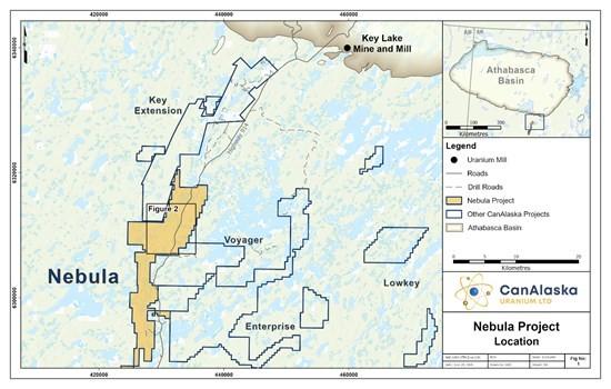
Figure 1 – Project Location Map
CanAlaska CEO, Cory Belyk, comments, “The first Nebula project drilling program by CanAlaska was a resounding success. Strongly graphitic fault zones in association with intense clay alteration are great indicators of the potential for uranium deposition nearby. On first pass drill programs the CanAlaska team looks for the right rocks, right structure and right alteration. All three are present in abundance on Nebula, which is a great start so early in the discovery process. I am optimistic the pending assay results will reveal the correct geochemical fingerprint to go along with these other positive features.”
2026 Nebula Exploration Drill Program
The 2026 winter drill program on the Nebula project consisted of eight diamond drill holes for a total of 1,618 metres in two target areas (Table 1; Figure 2). The program was focused on first-pass exploration testing of a series of high-priority target areas identified based on the recent airborne geophysical surveys and the review of historical drilling. Results from the winter program on the Nebula project were highlighted by a wide-graphitic package with multiple re-activated fault zones that had associated structurally-controlled hydrothermal alteration.
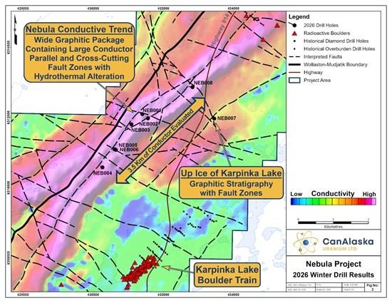
Figure 2 – Nebula Winter Drill Program Results
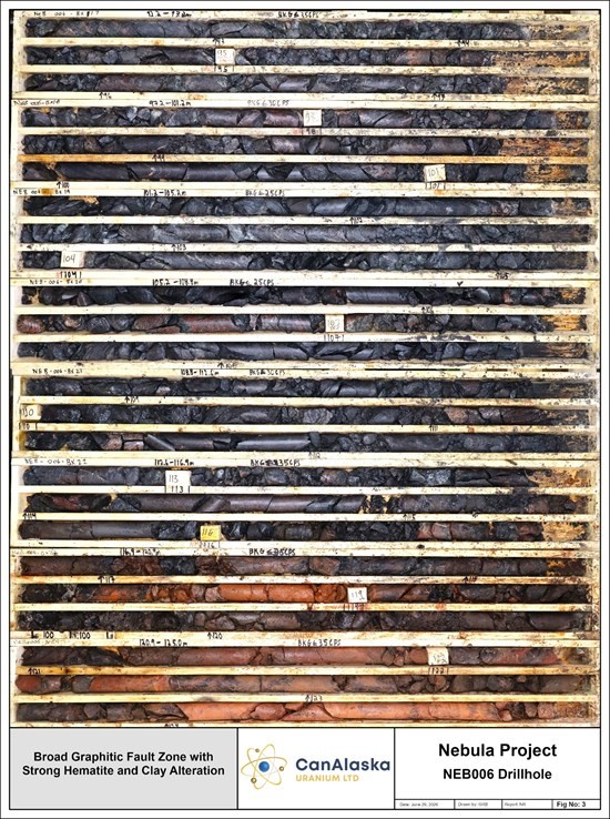
Figure 3 – NEB006 Core Photograph Showing Structure and Alteration
During the drill program, first-pass exploration testing of two high-priority target areas on the Nebula project was successfully completed:
Long-Linear Nebula Conductive Trend: Seven drillholes were completed as a first-pass test of a long linear conductive trend that runs the entire length of the Nebula project. This conductive trend is interpreted to represent over 32 kilometres of conductive target stratigraphy on the Project that parallels the highly prospective Wollaston-Mudjatik transition zone. During the winter drilling program, the Company successfully evaluated approximately 3.5 km of a previously untested 13-kilometre-long segment of this conductive corridor using a widely spaced drill pattern. Drilling results returned a wide package of strongly graphitic pelite with large conductor parallel and cross-cutting re-activated fault zones with hydrothermal chlorite alteration. In drillholes NEB005 and NEB006, strongly hematized and clay-altered fault structures, ranging from metre-scale to up to 35 metres in drill core length, were intersected and confirm the potential for a hydrothermal system that could produce basement-hosted uranium mineralization along this long linear conductive corridor (Figure 3).
Up-Ice of the Karpinka Lake Radioactive Boulder Field: One drillhole, NEB007, was completed to test a conductive target up-ice along the interpreted glacial ice direction of the historically reported Karpinka Lake radioactive boulder field. NEB007 successfully intersected graphitic stratigraphy with narrow fault zones. Results from NEB007 did not explain the source of the Karpinka Lake radioactive boulder field.
Overall, the drill program on the Nebula project was successful in completing first-pass evaluation of a small segment of the larger conductive corridor. Drill results revealed a broad continuous graphitic package with associated structural re-activation and hydrothermal alteration. Continued testing of the larger conductive corridor remains a priority for the Company. Specifically, future testing will be focused on areas of interpreted structural complexity, where bends and breaks in the conductive rocks associated with cross-cutting fault zones may create the potential for transport and trap of hydrothermal uranium-bearing mineralizing fluids.
Geochemical assay results from the winter drill program on the and Nebula project are pending.
Table 1 – 2026 Winter Drill Hole Collar Summary
| Drill Hole | Easting | Northing | Elevation (m A.S.L.) |
Azimuth (˚) |
Dip (˚) |
EOH (m) |
| NEB001 | 431403 | 6312095 | 559.9 | 300 | -72 | 206 |
| NEB002 | 431561 | 6311974 | 568.3 | 350 | -75 | 269 |
| NEB003 | 431089 | 6311806 | 565.3 | 300 | -69 | 143 |
| NEB004 | 430264 | 6310579 | 563.5 | 300 | -70 | 200 |
| NEB005 | 430614 | 6311095 | 564.6 | 297 | -75 | 142 |
| NEB006 | 430645 | 6311082 | 564.5 | 265 | -68 | 222 |
| NEB007 | 433452 | 6311972 | 561.9 | 280 | -68 | 209 |
| NEB008 | 432829 | 6312865 | 561.4 | 280 | -65 | 227 |
| Notes: Easting and Northing coordinates are reported in UTM Zone 13N (NAD83 datum). EOH = end of hole. m A.S.L. = metres above sea level. | ||||||
Technical Disclosure – Geochemical Assay Sampling Procedures, Historical Results, and Neighbouring Properties
All assay drill core samples from the program, completed as NQ-sized core, were shipped to the Saskatchewan Research Council Geoanalytical Laboratories (SRC) in Saskatoon, Saskatchewan in secure containment for preparation, processing, and multi-element analysis by ICP-MS and ICP-OES using total (HF:NHO3:HClO4) and partial digestion (HNO3:HCl), boron by fusion, and U3O8 wt% assay by ICP-OES using higher grade standards. Assay samples are chosen based on downhole probing radiometric equivalent uranium grades and scintillometer (SPP2 or CT007-M) peaks. Assay sample intervals comprise 0.3 – 0.8 metre continuous half-core split samples over the mineralized intervals. With all assay samples, one half of the split sample is retained and the other sent to the SRC for analysis. The SRC is an ISO/IEC 17025/2005 and Standards Council of Canada certified analytical laboratory. Blanks, standard reference materials, and repeats are inserted into the sample stream at regular intervals by CanAlaska and the SRC in accordance with CanAlaska’s quality assurance/quality control (QA/QC) procedures. Geochemical assay data are subject to verification procedures by qualified persons employed by CanAlaska prior to disclosure.
The historical results contained within this news release have been captured from the Saskatchewan Mineral Assessment Database (SMAD) as available and may be incomplete or subject to minor location inaccuracies. Management cautions that historical results collected and reported by past operators unrelated to CanAlaska have not been verified nor confirmed by a Qualified Person; however, the historical results form a scientific basis for ongoing work on the subject projects. Any historical rock / boulder samples are selective samples by nature and as such are not necessarily representative of the mineralization hosted across the property.
This news release refers to neighbouring properties in which the Company has no interest. Results, discoveries, or mineralization on proximate land or neighboring properties, whether in stated current resource estimates or historical resource estimates, are not necessarily indicative of results, discoveries, or mineralization on the Company’s properties.
All reported depths and intervals are drill hole depths and intervals, unless otherwise noted, and do not represent true thicknesses, which have yet to be determined.
About CanAlaska Uranium
CanAlaska is a leading explorer of uranium in the Athabasca Basin of Saskatchewan, Canada. With a project generator model, the Company has built a large portfolio of uranium projects in the Athabasca Basin. CanAlaska owns numerous uranium properties, totaling approximately 330,000 hectares, with clearly defined targets in the Athabasca Basin covering both basement and unconformity uranium deposit potential. The Company has recently concentrated on the West McArthur high-grade uranium expansion with targets in 2024 and 2025 leading to significant success at Pike Zone. Fully financed for the 2026 drill season, CanAlaska is focused on uranium deposit discovery and delineation in a safe and secure jurisdiction. The Company has the right team in place with a track record of discovery and projects that are located next to critical mine and mill infrastructure.
SAGA Metals Corp. (TSX-V: SAGA) (OTCQX: SAGMF) (FSE: 20H), a North American exploration company foc... READ MORE
Fredonia Mining Inc. (TSX-V: FRED) is pleased to announce that it has closed its previously announce... READ MORE
Legacy Gold Mines Ltd. (TSX-V: LEGY) is pleased to report assay results from core holes LG26-017 an... READ MORE
Inventus Mining Corp. (TSX-V: IVS) is pleased to report results from 100 drill holes from its now-... READ MORE
Abcourt Mines Inc. (TSX-V: ABI) (OTCQB: ABMBF) is pleased to present its operational report for the ... READ MORE


