


Dryden Gold Corp. (TSX-V: DRY) (OTCQX: DRYGF) (FSE: X7W) is pleased to announce the launch of its 2026 regional summer exploration program across its district-scale land package in the Dryden Gold District of Northwestern Ontario. The fully funded program will include extensive regional mapping and prospecting initiatives, heavy mineral concentrate sampling on targets identified from the Company’s 2025 gold-in-till substrate sampling program (Figure 1) and an expanded gold-in-till sampling program on newly acquired claims.
The 2026 exploration strategy is focused on five key initiatives designed to generate and prioritize new targets across the Dryden Gold District:
The Company will deploy three geological mapping crews and two prospecting teams throughout the summer and fall. The field program is designed to create and refine drill targeting and accelerate exploration across several high-priority zones identified through previous drilling, till sampling, structural interpretation, and LiDAR analysis.
These regional exploration efforts will complement the Company’s 45,000-metre drill program which is primarily focused on expanding and advancing the Company’s flagship Gold Rock Target Area where drilling will focus on growing the footprint across the multiple stacked hanging wall and footwall structures. A second drill rig is scheduled to commence operations in early July, allowing the Company to simultaneously evaluate deeper targets on Elora and Big Master. This rig will also be deployed for drilling at Mud Lake, Selby and Hyndman. Management believes these targets will demonstrate periodicity across the Gold Rock Camp and the potential to contribute significantly to district-scale growth. The program is expected to generate a steady stream of exploration results and news flow. The Company’s extensive logging and assaying protocol will continue to enhance our understanding of the structural and geological controls associated with high-grade gold mineralization at Gold Rock and gold mineralization throughout the district.
“The 2026 regional program represents a major step forward in unlocking the full potential of our land package,” said Anna Hicken, Vice President of Exploration. “By combining extensive fieldwork, advanced geological modelling, and aggressive drilling, we are positioning the Company to make meaningful discoveries and continue expanding known mineralized systems.” Link to Anna’s full presentation on the Exploration Program.
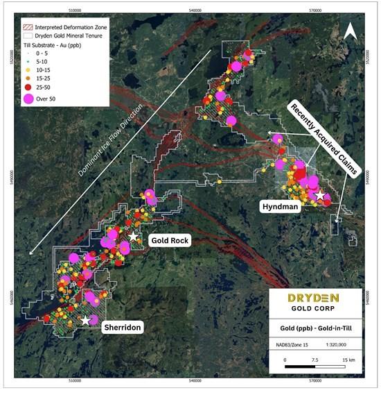
Figure 1: Gold-in-till results from 2025 Regional Program (previously released).
Gold-in-Till and Heavy Mineral Concentrates Sampling
The 2025 regional gold-in-till program was extremely successful at defining follow-up targets for this season’s regional exploration campaign. Newly acquired property along the trend of Hyndman will have the same gold-in-till program completed as our 2025 gold-in-till, giving us consistent data across the property.
The Company is undertaking an extensive HMC sampling program designed to follow up on the gold-in-till anomalies identified during last year’s exploration campaign. The anomaly map demonstrates widespread gold responses along the Manitou-Dinorwic Deformation Zone and extending toward the Hyndman area. The HMC approach has been selected because it enables the recovery and examination of individual gold grains, providing valuable information on grain morphology, transport distance, and potential source locations. Program design was completed in consultation with a Quaternary geology specialist and incorporates detailed assessments of glacial ice-flow directions, surficial geology, and till availability across the property.
To support the program, a detailed HMC sampling protocol has been developed, and field crews will receive specialized training prior to the commencement of sample collection. The program is expected to include approximately 740 HMC samples collected across the property. Sample locations have been planned using LiDAR data, till substrate information, and the Quaternary geology interpretation. Sampling will be conducted on an average grid spacing of 1,000 metres by 500 metres, consistent with recommendations provided by the laboratory doing the grain analysis. This design will provide extensive coverage across a significant portion of the property and will help refine exploration targets for future follow-up work.
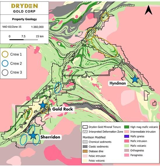
Figure 2: 2026 Summer Mapping and Sampling Program
Mapping and Prospecting Program
The mapping program (Figure 2) will be conducted by three field crews, all of which are already active in the field. Their primary objective is to advance exploration in key strategic areas identified through gold-in-till results, structural interpretations, and exploration priorities. Regional mapping will be completed at scales ranging from 1:20,000 to 1:30,000 across a significant portion of the property. A third crew will focus on detailed mapping within the Hyndman and Sandy Beach areas to further refine geological interpretations and identify potential exploration targets.
The prospecting program will be closely integrated with the mapping effort. Two prospecting crews will be deployed throughout the field season. The first crew will operate from June through September, working in parallel with the mapping teams, while the second crew will continue prospecting activities from September until the onset of winter conditions, anticipated around early November. A key objective of the program is to maximize field coverage while maintaining a strong emphasis on high-quality geological observations and systematic sample collection.
Regional Geological Model
The Team has also initiated the development of a comprehensive regional geological model (Figure 3), which will serve as a critical framework for integrating and interpreting data collected throughout the summer field season. The model incorporates key lithological and rheological controls observed within the Gold Rock area, as well as important regional unconformities and intrusive bodies. This integrated approach enhances our understanding of the geological architecture of the property and supports more effective targeting of mineralized systems.
The model is designed to accommodate multiple deposit styles, including orogenic greenstone-hosted gold mineralization at Gold Rock, intrusion-related and structurally controlled mineralization observed at Hyndman and Sherridon, and hybrid systems such as the Goliath deposit, which exhibits characteristics of volcanogenic massive sulphide mineralization overprinted by later orogenic gold events. All mapping, till sampling, and prospecting data collected during the summer program will be incorporated into the regional geological model during the fall, providing an updated framework to guide future exploration and target generation.
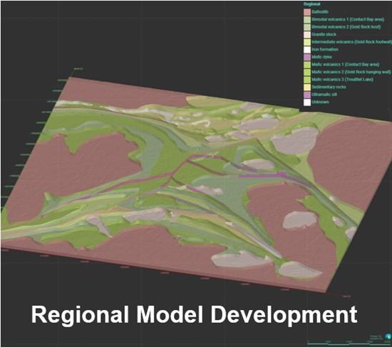
Figure 3: Dryden District 3D Regional Model
Qualified Person
The technical disclosure in this news release has been reviewed and approved by Maura Kolb, M.Sc., P. Geo., President of Dryden Gold and a Qualified Person as defined by National Instrument 43-101 of the Canadian Securities Administrators.
Analytical Laboratory and QA/QC Procedures
The Company is drilling NQ size core. Samples are cut in half, with half going to the lab for analysis and half kept as a record. True thickness/widths of the mineralization is unknown, result intervals are reported as the drilled core lengths unless otherwise stated. All sampling completed by Dryden Gold Corp. within its exploration programs is subject to a Company standard of internal quality control and quality assurance (QA/QC) programs which include the insertion of certified reference materials, blank materials, and a level of duplicate analysis. Drill samples from the 2024, 2025 and 2026 programs were sent to Activation Laboratories, with sample preparation and analysis in Dryden, where they were processed for gold analysis by 50-gram fire assay with an atomic absorption finish and over limits determined by Fire Assay with a gravimetric finish. Select samples were analyzed using metallic screens. Activation Laboratories systems conform to requirements of ISO/IEC Standard 17025 guidelines and meets assay requirements outlined for NI 43-101.
ABOUT DRYDEN GOLD CORP.
Dryden Gold Corp. is an exploration Company focused on the discovery of high-grade gold mineralization listed on the TSX Venture Exchange (“DRY“), on the OTCQX marketplace (“DRYGF“) and on the FSE: (“X7W“). The Company has a strong management team and Board of Directors comprised of experienced individuals with a track record of building shareholder value through property acquisition and consolidation, exploration success, and mergers and acquisitions. Dryden Gold controls a 100% interest in a dominant strategic land position in the Dryden District of Northwestern Ontario. Dryden Gold’s property package includes historic gold mines but has seen limited modern exploration. The property hosts high-grade gold mineralization over 50km of potential strike length along the Manitou-Dinorwic deformation zone. The property has excellent infrastructure, enjoys collaborative relationships with First Nations communities and benefits from proximity to an experienced mining workforce.
Michael Fox sits down with Kit Marrs and incoming leader Aaron Schutt of... READ MORE
Resouro Strategic Metals Inc. (ASX: RAU) (TSX-V: RSM) (OTCQB: RSG... READ MORE
Cartier Resources Inc. (TSX-V: ECR) announces that at its annual ... READ MORE
Lomiko Metals (TSX-V: LMR) (OTC: LMRMD) (FSE: DH8C) CEO Gordana Slepcev ... READ MORE


