


Scorpio Gold Corp. (TSX-V: SGN) (OTCQB: SRCRF) (FSE: RY9) is pleased to announce results from two step-out holes of the Phase Two drill program at the Manhattan District Project, Nevada, USA: 26MN-078 and 26MN-088, see Figure 1. The results are tabulated in Table 1 and discussed below. Scorpio Gold has drilled 91 drill holes to date from its Phase Two diamond drilling program, 25MN-011 through 25MN-045, 26MN-046 through 26MN-101, for a grand total of 25,838 m. With the results herein, Scorpio Gold has reported assays on 73 of these (25MN-011 through 25MN-045, 26MN-046 through 26MN-080, and 26MN-083, 26MN-085, and 26MN-088), totalling 21,962 m, and assays are pending from 18 holes (26MN-081 and 26MN-082, 26MN-084, 26MN-086 and 26MN-087, and 26MN-089 through 26MN-101), totalling 3,876 m. The pending results will be reported as they become available. In addition to the Phase Two drill program, the Company has begun reviewing historic core that is available at Manhattan. Any new significant results will be included as they become available, such as drill hole GW07-04, which is included in Table 1and discussed below.
“We continue to intersect gold mineralization within the volcanic tuffs of the Oligocene Round Rock Formation — the caldera-fill volcanics — at Black Mammoth. Multiple holes drilled at Black Mammoth have now returned mineralization in these volcanic units, and the intercepts are wide, consistent, and remain open. This is similar to the geological setting at Round Mountain, where broad, disseminated gold mineralization is hosted within the caldera-fill volcanics and has supported decades of open pit mining.
At Black Mammoth, we are now drilling into the northern end of the current defined deposit where the caldera margin — the contact between the Ordovician sediments and the Oligocene volcanic package — becomes an increasingly dominant feature. Critically, this zone had never been tested with modern drilling prior to our program, making these results all the more significant. The repeatability of mineralization within the volcanic tuffs across multiple holes gives us confidence that this has the potential to not just be a narrow vein system. If the analogy to Round Mountain holds, the potential for wide, bulk-tonnage zones within the caldera volcanics at the north end of the Manhattan District is a genuinely compelling exploration target that we have only begun to test. Alongside our continued success at Zanzibar, we believe Black Mammoth is emerging as a second major growth front capable of adding meaningful ounces to the Manhattan District,” said Harrison Pokrandt, VP Exploration for Scorpio Gold.

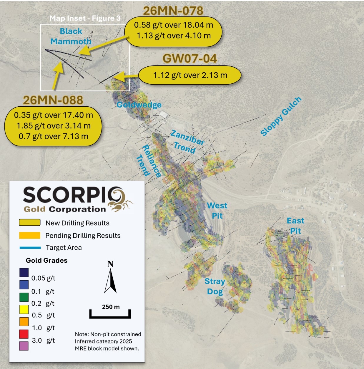
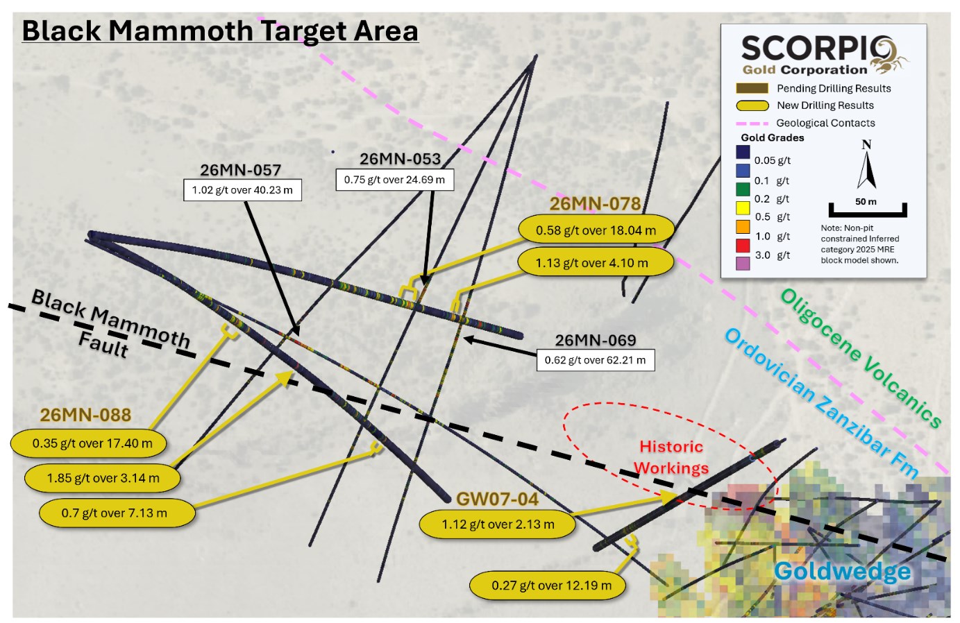
Figure 1. Surface Plan Map of drill results, with highlights noted. Map Inset area shown in Figure 3.
To view an enhanced version of this graphic, please visit:
https://images.newsfilecorp.com/files/9779/299793_07c6cc0d343cb9d9_002full.jpg
Drill holes 26MN-078 is a 50 m step-out, at Black Mammoth, to the northeast of hole 26MN-057, see news release dated April 1, 2026. This hole additionally steps out on and confirms mineralization in drill holes 26MN-053, see news release dated March 19, 2026, and 26MN-069, see news release dated May 7, 2026. Drill hole 26MN-088 is a 50 m step-out, also at Black Mammoth, to the southwest of hole 26MN-057. Both drill holes tested greater than 250 metres beyond the Inferred Resource Constraining Pit, targeting new mineralization outside of the 2025 MRE block model, see Figures 2 and 3. Historic drill hole GW07-04 was previously drilled in the area between Goldwedge and the heart of Black Mammoth, drilled through and below the IRCP. For further details see “Mineral Resource Estimate and NI 43-101 Technical Report, Manhattan Property, Nye County, Nevada” with an effective date of June 4, 2025, on Scorpio Gold’s website at https://wp-scorpiogold-2025.s3.ca-central-1.amazonaws.com/media/2025/10/SGN_Manhattan_Mineral_Resource_Estimate_-_Amended_43-101.pdf.

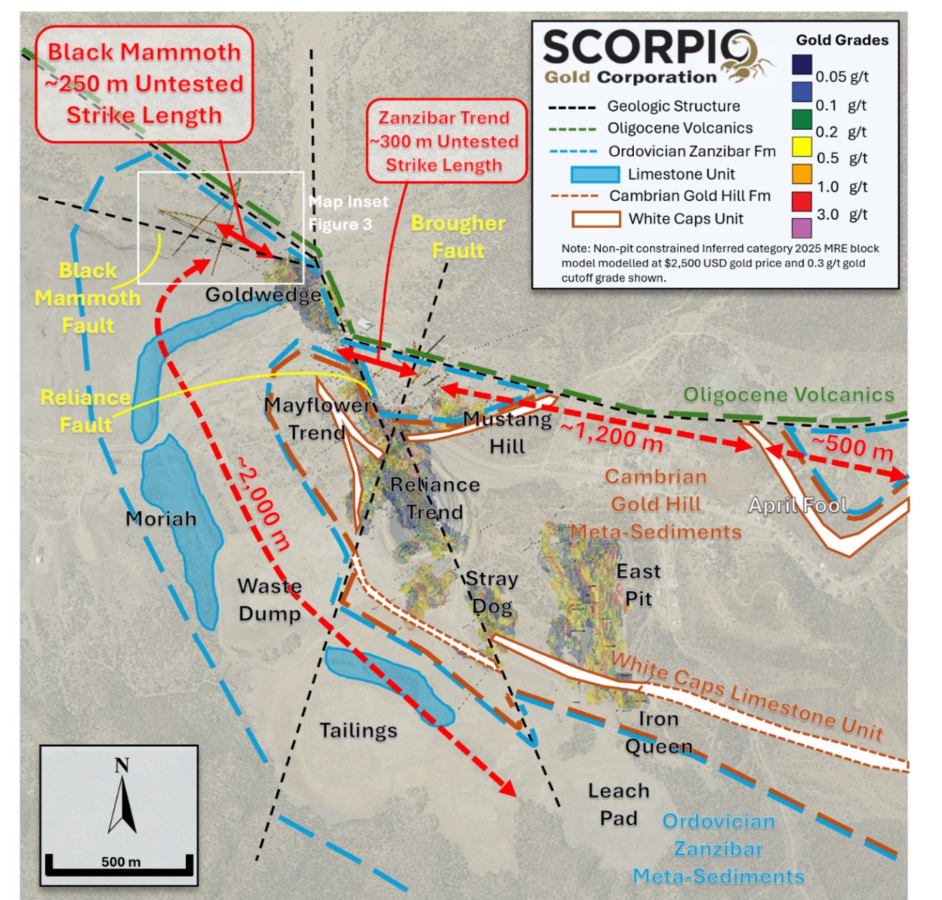
Figure 2. Geology Surface Plan Map of Target Areas, with untested strike lengths through the Ordovician Zanzibar Formation associated mineralization noted. Map Inset area shown in Figure 3.
To view an enhanced version of this graphic, please visit:
https://images.newsfilecorp.com/files/9779/299793_07c6cc0d343cb9d9_003full.jpg
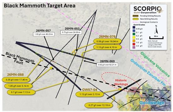
Figure 3. Inset Surface Plan Map of Black Mammoth Target Area, with drill hole traces projected to surface and result highlights noted.
To view an enhanced version of this graphic, please visit:
https://images.newsfilecorp.com/files/9779/299793_07c6cc0d343cb9d9_004full.jpg
| Drill Hole ID | Target Azimuth / Dip |
From (m) | To (m) | Intercept¹ (m) | Gold (g/t) |
| 26MN-078 | Black Mammoth | 246.37 | 256.49 | 10.12 | 0.33 |
| 446 m | 100° / -45° | 261.22 | 267.86 | 6.64 | 0.23 |
| 286.45 | 292.30 | 5.85 | 0.23 | ||
| 311.05 | 329.09 | 18.04 | 0.58 | ||
| 367.88 | 371.98 | 4.10 | 1.13 | ||
| 376.43 | 386.96 | 10.53 | 0.22 | ||
| 396.21 | 404.44 | 8.23 | 0.5 | ||
| 26MN-088 | Black Mammoth | 136.43 | 145.48 | 9.05 | 0.19 |
| 550 m | 115° / -55° | 185.96 | 203.36 | 17.40 | 0.35 |
| 284.56 | 287.70 | 3.14 | 1.85 | ||
| 379.26 | 385.02 | 5.76 | 0.41 | ||
| 424.41 | 431.54 | 7.13 | 0.7 | ||
| including | 430.05 | 431.54 | 1.49 | 2.55 | |
| GW07-04 | Black Mammoth | 32.92 | 51.21 | 18.29 | 0.14 |
| 334 m | 240° / -65° | 178.62 | 180.75 | 2.13 | 1.12 |
| 258.78 | 268.99 | 10.21 | 0.2 | ||
| 272.19 | 284.38 | 12.19 | 0.27 | ||
| ¹ Intervals contain no more than 3 continuous metres grading less than 0.1 g/t gold. | |||||
Table 1. Results from the current batch of drill holes. Note: There is insufficient geological information to estimate a true width for the drill intercepts reported.
Black Mammoth Results:
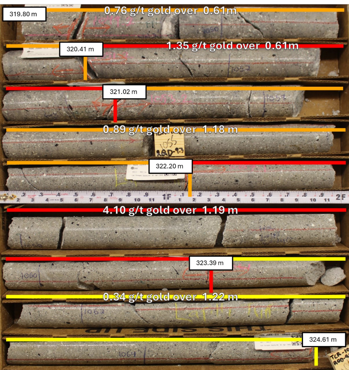
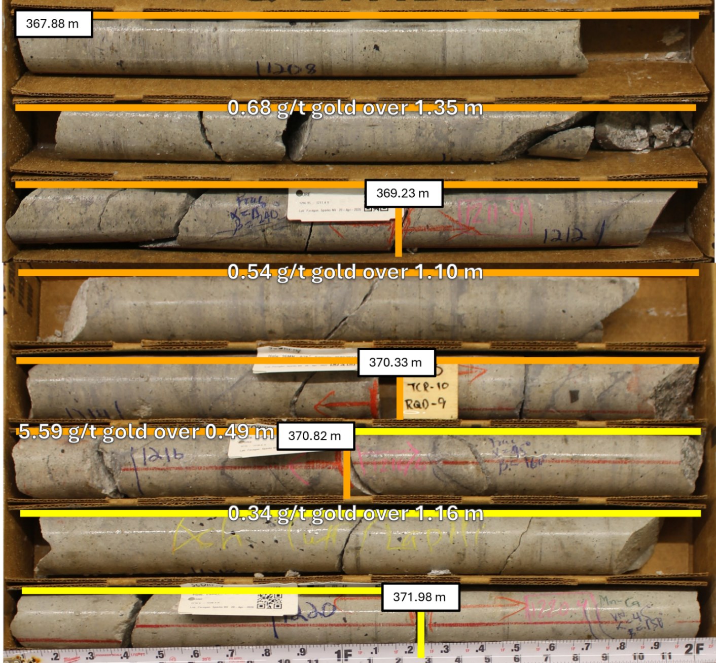
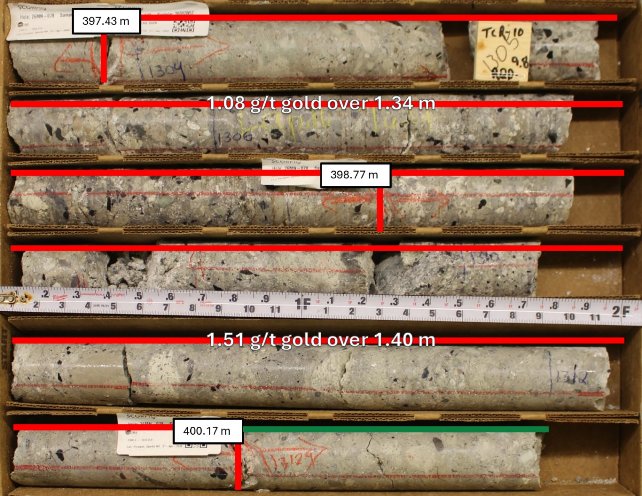
26MN-078: This drill hole tested mineralization in the Black Mammoth area, to the northwest of Goldwedge. The drill hole contains three intervals hosted in Ordovician Zanzibar Formation limestone units, including 0.33 g/t gold over 10.12 m from 246.37 m, 0.23 g/t gold over 6.64 m from 261.22 m, and 0.23 g/t gold over 5.85 m from 286.45 m. The drill hole contains three intervals hosted in Oligocene Round Rock Formation volcanic units, below the Ordovician-Oligocene contact at 304.62 m, including 0.58 g/t gold over 18.04 m from 311.05 m (see Figure 4), 1.13 g/t gold over 4.10 m from 367.88 m (see Figure 5), 0.22 g/t gold over 10.53 m from 376.43 m, and 0.50 g/t gold over 8.23 m from 396.21 m (see Figure 6).
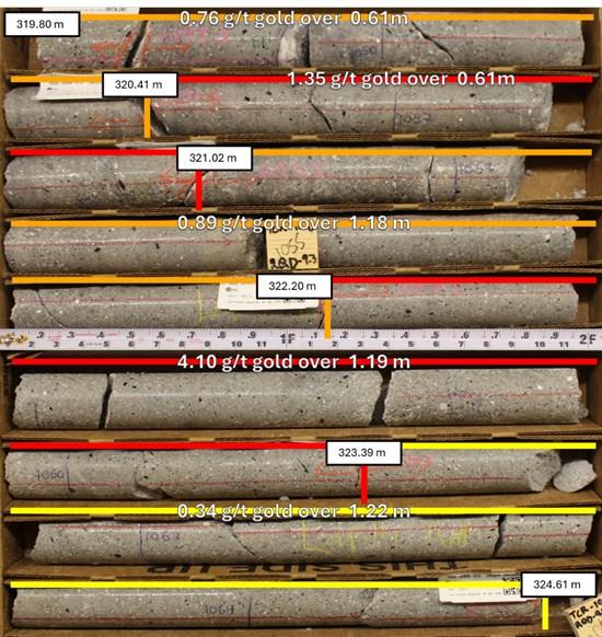
Figure 4. Drill hole 26MN-078, interval 319.80 m to 324.61 m, displaying mineralized volcanic tuff units within the Oligocene Round Rock Formation.
To view an enhanced version of this graphic, please visit:
https://images.newsfilecorp.com/files/9779/299793_07c6cc0d343cb9d9_005full.jpg
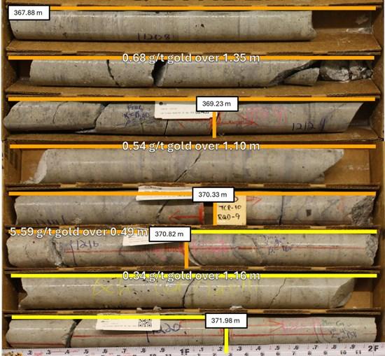
Figure 5. Drill hole 26MN-078, interval 367.88 m to 371.98 m, displaying mineralized volcanic tuff units within the Oligocene Round Rock Formation.
To view an enhanced version of this graphic, please visit:
https://images.newsfilecorp.com/files/9779/299793_07c6cc0d343cb9d9_006full.jpg
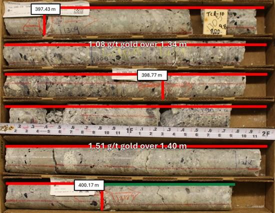
Figure 6. Drill hole 26MN-078, interval 397.43 m to 400.17 m, displaying mineralized volcanic tuff units within the Oligocene Round Rock Formation.
To view an enhanced version of this graphic, please visit:
https://images.newsfilecorp.com/files/9779/299793_07c6cc0d343cb9d9_007full.jpg
26MN-088: This drill hole also tested mineralization in the Black Mammoth area, to the northwest of Goldwedge. The drill hole contains three significant intervals hosted in Ordovician Zanzibar Formation limestone units, including 0.19 g/t gold over 9.05 m from 136.43 m, 0.35 g/t gold over 17.4 m from 185.96 m, and 1.85 g/t gold over 3.14 m from 284.56 m. The drill hole contains three significant intervals hosted in Cambrian Gold Hill Formation meta-sediments, including 0.41 g/t gold over 5.76 m from 379.26 m, 0.70 g/t gold over 7.13 m from 424.41 m (marble), and 2.55 g/t gold over 1.49 m from 430.05 m.
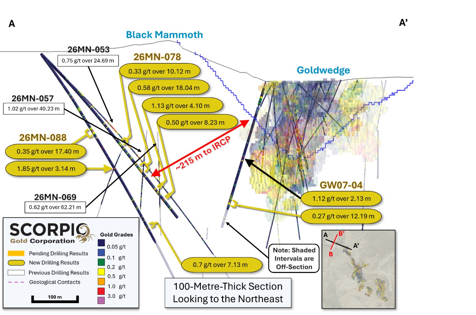
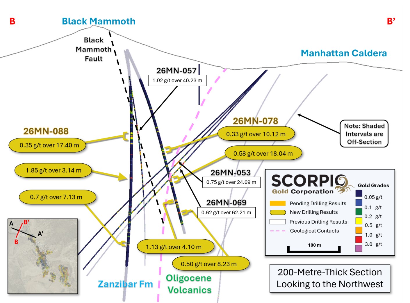
These Black Mammoth intervals represent new mineralization outside the current IRCP, see cross-section A to A’ (Figure 7) and cross-section B to B’ (Figure 8).
GW07-04: This historic drill hole was drilled to the north of Goldwedge, and to the southeast of the current core of Black Mammoth, partially within and below the current IRCP. The drill hole contains two significant intervals hosted in Ordovician Zanzibar Formation limestone units, including 0.14 g/t gold over 18.29 m from 32.92 m and 1.12 g/t gold over 2.13 m from 178.62 m. The drill hole contains two significant intervals hosted in Cambrian Gold Hill Formation meta-sediments, including 0.2 g/t gold over 10.21 m from 258.78 m and 0.27 g/t gold over 12.19 m from 272.19 m. This drill hole represents resampled mineralization within and below the IRCP, but not currently contributing to the block model, see cross-section A to A’ (Figure 7) and cross-section B to B’ (Figure 8).
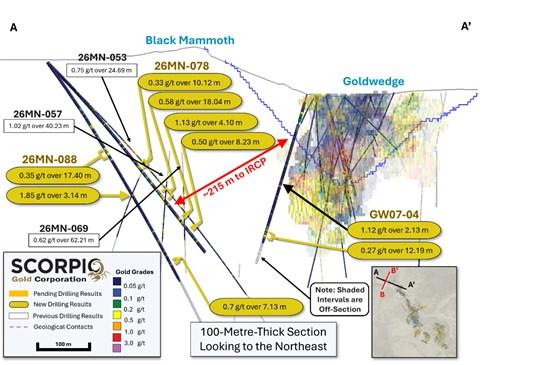
Figure 7. Cross-section A-A’, showing gold grades with reported intervals highlighted.
To view an enhanced version of this graphic, please visit:
https://images.newsfilecorp.com/files/9779/299793_07c6cc0d343cb9d9_008full.jpg
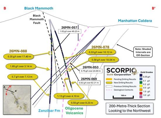
Figure 8. Cross-section B-B”, showing gold grades with reported intervals highlighted.
To view an enhanced version of this graphic, please visit:
https://images.newsfilecorp.com/files/9779/299793_07c6cc0d343cb9d9_009full.jpg
QA/QC
HQ sized diamond drill core samples were cut in halves, then bagged and secured with security tags to ensure integrity during transportation to the Reno, NV, Paragon Geochemical facility for preparation. For quality assurance, unmarked coarse blanks, unmarked certified reference materials, and requested laboratory duplicates were inserted into the sampling sequence. QA samples were systematically inserted into each batch of samples, amounting to approximately 10% of the run of samples. Samples were analyzed for gold using method PA-AU02 (~500 g), a two-cycle PhotonAssayTM analysis of crushed material (70% passing 2 mm). All Paragon Geochemical facilities comply with ISO 17025:2017.
About the Manhattan District
Manhattan, located in the Walker Lane Trend of Nevada, USA, is road accessible and lies approximately 20 kilometers south of the operating Round Mountain Gold Mine (https://www.kinross.com/operations/default.aspx#americas-roundmountain), which has produced more than 15 million ounces of gold. For the first time, the Company has consolidated Manhattan’s past-producing mines under a single entity that holds valuable permitting and water rights. Historically, Manhattan has produced approximately 700,000 ounces of gold from high-grade placer and lode operations dating from the late 1890s through to the mid-2000s.¹ The maiden mineral resource estimate covering the Goldwedge and Manhattan Pit areas of Manhattan is comprised of 18,343,000 tonnes grading 1.26 g/t gold for a total of 740,000 oz contained gold in the inferred category.²
A historical mineral resource estimate covers the Black Mammoth, April Fool, Hooligan, Keystone, and Jumbo areas of Manhattan and comprises 1,652,325 tonnes grading 5.89 g/t gold for a total of 303,949 oz contained gold.³ The deposit is interpreted as a low-sulfidation, epithermal, gold-rich system situated adjacent to the Tertiary-aged Manhattan caldera in the Southern Toquima Range of Nevada. A “Qualified Person” as defined in National Instrument 43-101 – Standards of Disclosure for Mineral Projects has not done sufficient work to make the Historical MRE current, and the Company is not treating the Historical MRE as current.
Notes
The Company considers the Historical MRE relevant as it demonstrates the presence of significant gold mineralization across multiple zones within Manhattan; however, its reliability is uncertain because it was prepared prior to the adoption of the current CIM Definition Standards and current QA/QC practices. The Historical MRE provides limited disclosure of assumptions, parameters, estimation methods, cutoff grades, and QA/QC protocols, and therefore these cannot be fully verified by the Company. The categories used in the historical estimate predate, and are not directly comparable to, current CIM Definition Standards, and the Company is not treating the Historical MRE as a current Mineral Resource Estimate. To upgrade and verify the Historical MRE in order to make it a current Mineral Resource Estimate, the Company would be required to undertake confirmatory drilling, modern QA/QC sampling, validation and digitization of historical datasets and updated geological modeling followed by the preparation of a new Mineral Resource Estimate in accordance with CIM Definition Standards and NI 43-101. The Company encourages readers to exercise appropriate caution when evaluating the Historical MRE.
All scientific and technical information relating to Manhattan pertaining to the Historical MRE contained in this news release is derived from the Technical Report dated May 1997 titled “Exploration and Pre-Production Mine Development, Manhattan District Project, Nye County” prepared by New Concept Mining, Inc. The information contained herein in respect of the Historical MRE is subject to all the assumptions, qualifications and procedures set out in the Historical Technical Report and reference should be made to the full text of the Historical Technical Report.
Qualified Person
The scientific and technical information in this news release has been reviewed, verified and approved by Thomas Poitras, P. Geo., Chief Geologist of Scorpio Gold, a “Qualified Person”, as defined under National Instrument 43-101 Standards of Disclosure for Mineral Projects. Verification included review of laboratory certificates, review of field logs and chain-of-custody records, inspection of blank/standard/duplicate performance, and review of collar and down-hole survey data. No limitations or failures to verify were identified.
About Scorpio Gold Corp.
Scorpio Gold holds a 100% interest in the Manhattan District located in the Walker Lane Trend of Nevada, USA. Scorpio Gold’s Manhattan District is ~4,780-hectares and comprises the advanced exploration-stage Goldwedge Mine, with a 400 ton per day maximum capacity gravity mill, and four past-producing pits that were acquired from Kinross in 2021 (see news release dated March 25, 2021 https://scorpiogold.com/news/scorpio-gold-closes-purchase-of-kinross-manhattan-property-nye-county-nevada/). The consolidated Manhattan District presents an exciting late-stage exploration opportunity, with over 140,000 metres of historical drilling, significant resource potential, and valuable permitting and water rights.
Neither the TSX Venture Exchange nor its Regulation Services Provider (as that term is defined in the policies of the Exchange) accepts responsibility for the adequacy or accuracy of this release.
ON BEHALF OF THE BOARD OF SCORPIO GOLD CORPORATION
Zayn Kalyan, Chief Executive Officer and Director
Tel: (604)-252-2672
Email: zayn@scorpiogold.com
Investor Relations Contact:
Kin Communications Inc.
Tel: (604) 684-6730
Email: SGN@kincommunications.com
Connect with Scorpio Gold:
Email | Website | Facebook | LinkedIn | X | YouTube
To register for investor updates please visit: scorpiogold.com
(TSX-V: SGN) (OTCQB: SRCRF) (FSE: RY9)
Emerita Resources Corp. (TSX-V: EMO) (OTCQX: EMOTF) (FSE: LLJA) reports results from recent drilling... READ MORE
GreenLight Metals Inc. (TSX-V: GRL) (OTCQB: GRLMF) is pleased to provide an update on the dri... READ MORE
VIOR GOLD CORPORATION INC. (TSX-V: VIO) (OTCQB: VIORF) (FRA: VL5) is pleased to announce new results... READ MORE
Aya Gold & Silver Inc. (TSX: AYA) (NASDAQ: AYA) is pleased to announce high-grade silver ... READ MORE
Emperor Metals Inc. (CSE: AUOZ) (OTCQB: EMAUF) (FSE: 9NH) is pleased to report on the progress of i... READ MORE


