


Highlights
Scorpio Gold Corp. (TSX-V: SGN) (OTCQB: SRCRF) (FSE: RY9) is pleased to announce results from five step-out holes and one exploration hole of the Phase Two drill program at the Manhattan District Project, Nevada, USA: 26MN-049 through 26MN-054, see Figure 1. The results are tabulated in Table 1 and discussed below. Scorpio Gold has drilled 56 drill holes to date from its Phase Two diamond drilling program, 25MN-011 through 25MN-045, 26MN-046 through 26MN-066, for a grand total of 18,228 m. With the results herein, Scorpio Gold has reported assays on 42 of these (25MN-011 through 25MN-054), totalling 14,334 m, and assays are pending from 14 holes (26MN-055 through 26MN-066), totalling 3,894 m. The pending results will be reported as they become available.
“Results from hole 26MN-053 at Black Mammoth reinforces our belief that strong gold mineralization continues along the caldera margin to the northwest of Goldwedge, outside the current Inferred Resource Constraining Pit. With mineralization hosted primarily within brecciated volcanic units, the 24.69 metre interval grading 0.75 g/t gold from 230.12 metres signifies the potential for blue-sky opportunities along this margin through the district. With results pending from hole 26MN-057, our second hole at Black Mammoth, we are already planning follow-up holes,” stated Harrison Pokrandt, VP Exploration of Scorpio Gold.
“We are very pleased to have confirmed the presence of gold mineralization in this zone, which supports our broader thesis of district-scale potential along the caldera margin. Importantly, Black Mammoth holds significant development potential given its proximity to the permitted Goldwedge underground, creating a unique opportunity to potentially access and develop mineralization from underground ahead of any larger-scale open pit development. This positioning may also allow us to efficiently advance exploration by drilling from underground workings into the target area. Combined with continued strong results along the Reliance Trend and the newly defined Zanzibar Trend, we remain focused on systematically expanding mineralization outside the current resource footprint and advancing multiple growth fronts across Manhattan,” commented Zayn Kalyan, CEO and Director of Scorpio Gold.
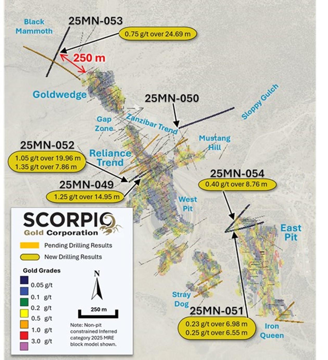
Figure 1. Surface Plan Map of drill results, with highlights noted.
Drill hole 26MN-053 was drilled at Black Mammoth as a 250 m exploratory step-out from Goldwedge. This drill hole tested the faulted contact zone between caldera volcanics and Zanzibar Formation meta-sedimentary units, see Figure 2. Two drill holes stepped out on drill hole 25MN-042 along the Reliance Trend, see news release dated February 11, 2026. Drill hole 26MN-049, a 50 m step-out to the southwest of 25MN-042, and 26MN-052, a 50 m step-out to the southwest of 26MN-049, followed up on 25MN-042. Drill holes 26MN-051 and 26MN-054 were drilled to the north of the historic East Pit, both as 50 m step-outs from drill hole 25MN-043 (see news release dated February 11, 2026) to test a northerly extension of a mineralized fault splay. Drill hole 26MN-050 was an exploration hole to the northeast of Mustang Hill to test magnetic and soil anomalies. All the drill holes tested beyond the Inferred Resource Constraining Pit (“IRCP”), see Figure 5. Step-out drill holes targeted non-pit constrained inferred category mineralization and uncategorized mineralization. For further details see “Mineral Resource Estimate and NI 43-101 Technical Report, Manhattan Property, Nye County, Nevada” with an effective date of June 4, 2025, on Scorpio Gold’s website at https://wp-scorpiogold-2025.s3.ca-central-1.amazonaws.com/media/2025/10/Scorpio-Gold-Manhattan-Mineral-Resource-Estimate-43-101-FINAL-2025-10-23.pdf.
Table 1. Results from the current batch of drill holes. Note: There is insufficient geological information to estimate a true width for the drill intercepts reported.
| Drill Hole ID | Target Azimuth / Dip |
From (m) | To (m) | Intercept¹ (m) | Gold (g/t) |
| 26MN-049 | Reliance Trend | 9.20 | 16.61 | 7.41 | 0.88 |
| 309 m | 060° / -60° | ||||
| including | 12.59 | 16.61 | 4.02 | 1.57 | |
| 47.25 | 52.58 | 5.33 | 0.64 | ||
| including | 47.25 | 50.05 | 2.80 | 1.09 | |
| 202.95 | 217.90 | 14.95 | 1.25 | ||
| including | 208.94 | 211.47 | 2.53 | 5.43 | |
| 26MN-050 | Sloppy Gulch | No significant intercepts. | |||
| 520 m | 070° / -45° | ||||
| 26MN-051 | East Pit | 118.29 | 125.27 | 6.98 | 0.23 |
| 401 m | 080° / -45° | 159.72 | 166.27 | 6.55 | 0.25 |
| 26MN-052 | Reliance Trend | 17.71 | 45.11 | 27.40 | 0.30 |
| 352 m | 060° / -60° | 64.71 | 79.07 | 14.36 | 0.24 |
| 141.43 | 161.39 | 19.96 | 1.05 | ||
| 190.74 | 195.01 | 4.27 | 0.80 | ||
| 208.85 | 219.67 | 10.82 | 0.24 | ||
| 223.78 | 242.83 | 19.05 | 0.28 | ||
| 247.59 | 249.63 | 2.04 | 3.49 | ||
| 312.58 | 320.44 | 7.86 | 1.35 | ||
| 26MN-053 | Black Mammoth | 230.12 | 254.81 | 24.69 | 0.75 |
| 510 m | 206° / -45° | 364.54 | 376.18 | 11.64 | 0.24 |
| 401.73 | 407.43 | 5.70 | 0.35 | ||
| 26MN-054 | East Pit | 257.89 | 266.65 | 8.76 | 0.40 |
| 335 m | 040° / -45° | ||||
| ¹ Intervals contain no more than 3 continuous metres grading less than 0.1 g/t gold. | |||||
Black Mammoth Results:
26MN-053: This drill hole tested the Black Mammoth Fault and associated mineralization, as it trends to the NW from Goldwedge. The drill hole contains one interval hosted in Oligocene Round Rock Formation volcanic tuffs, see Figure 3, directly above the faulted Ordovician Zanzibar Formation contact (“Caldera Margin”), see Figure 4, section A to A’. The interval contains 0.75 g/t gold over 24.69 m from 230.12 m. Two deeper intervals exist within Cambrian Gold Hill Formation fine-grained meta-mudstones and siltstones. Intervals include 0.24 g/t gold over 11.64 m from 364.54 m and 0.35 g/t gold over 5.7 m from 401.73 m. All intervals represent new mineralization, and the upper interval is approximately 250 m to the NW of the edge of the IRCP, see Figure 5, section B to B’.
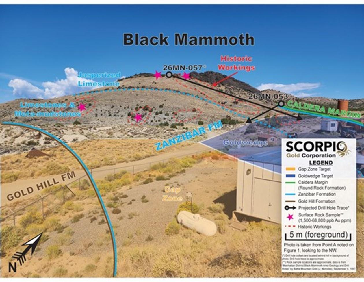
Figure 2. Annotated photo of Black Mammoth. Photo is taken from Point A, noted on Figure 1, looking to the northwest. Note the drill holes indicated are located behind the hill in the background.
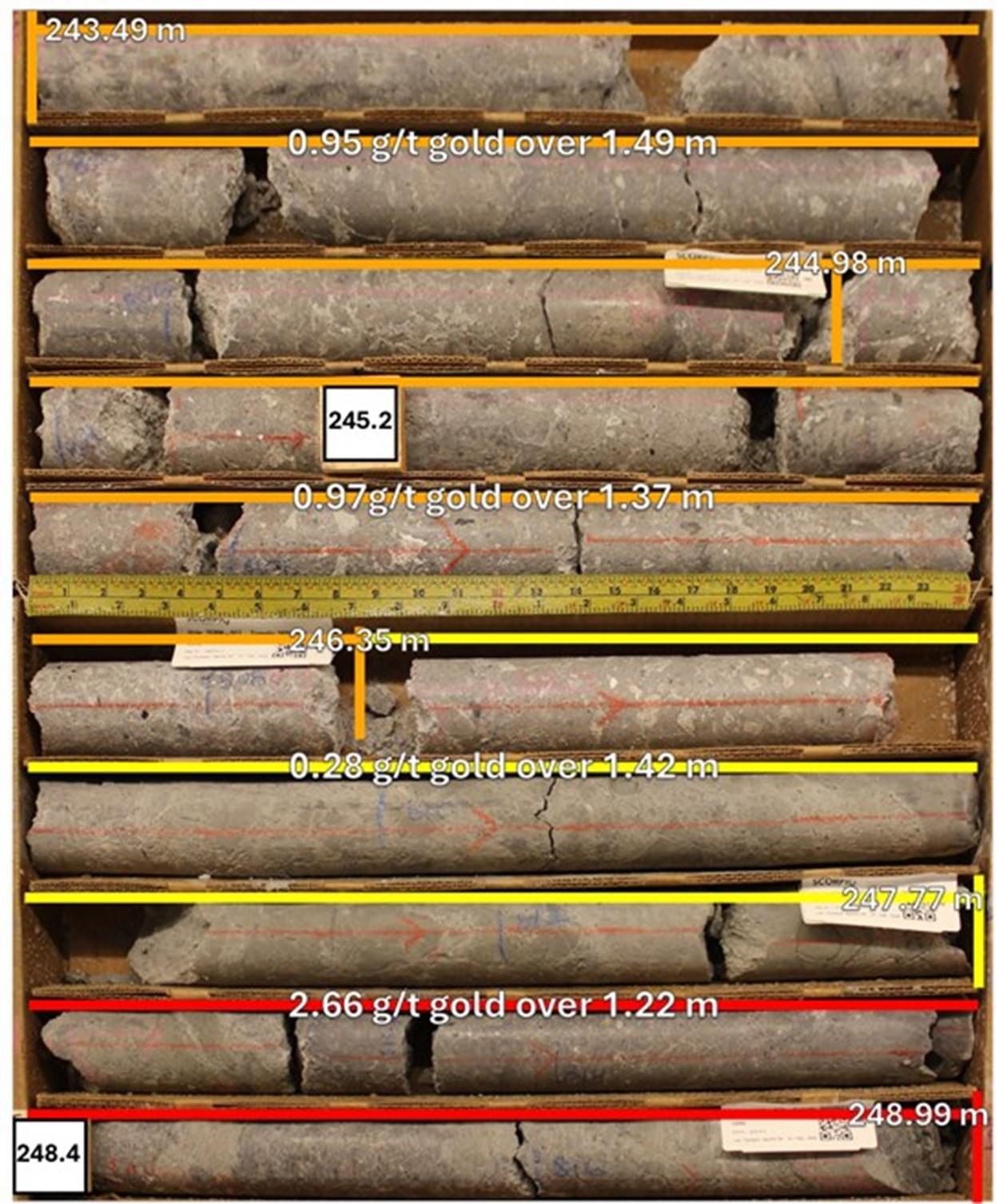
Figure 3. Drill hole 26MN-053, interval 243.49 to 248.99 m, displaying Oligocene Round Rock Formation volcanic tuffs with fine grained quartz-calcite epithermal breccia matrix.
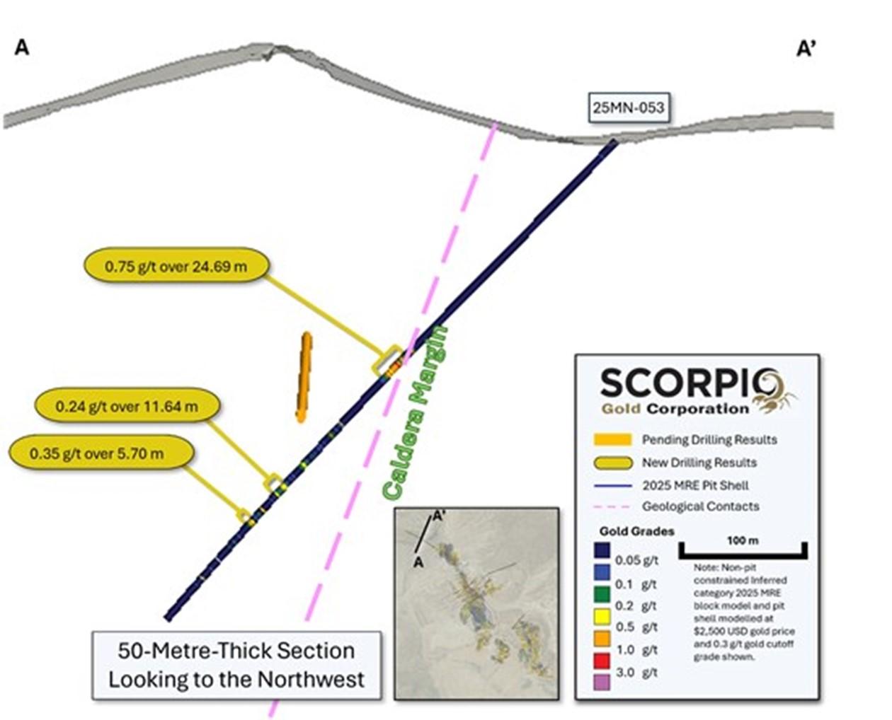
Figure 4. Cross-section A-A’, showing gold grades with reported intervals highlighted.
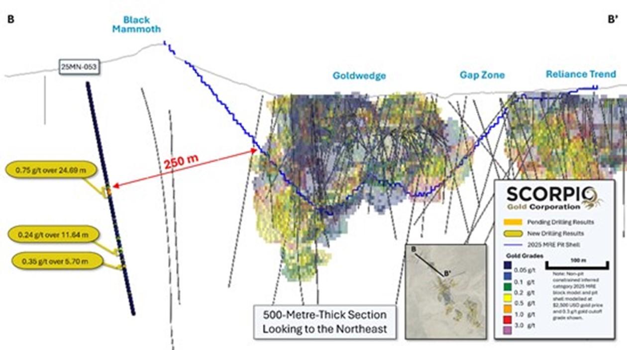
Figure 5. Long-section B-B’, showing gold grades with reported intervals highlighted.
Reliance Trend Results:
26MN-049: contains three intervals hosted in the Cambrian Gold Hill Formation along the Reliance Trend to the north of the West Pit. These intervals are hosted in fine grained meta-sedimentary clastic and carbonate units, including 0.88 g/t gold over 7.41 m from 9.2 m, including 1.57 g/t gold over 4.02 m from 12.59 m; 0.64 g/t gold over 5.33 m from 47.25 m, including 1.09 g/t gold over 2.8 m from 47.25 m; and 1.25 g/t gold over 14.95 m from 202.95 m, including 5.43 g/t gold over 2.53 m from 208.94 m (see Figure 6). See Figure 7, section C to C’.
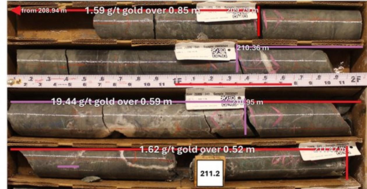
Figure 6. Drill hole 26MN-049, interval 208.94 to 211.47 m, displaying Cambrian Gold Hill Formation fine grained meta-sediments with quartz-calcite-adularia-fluorite epithermal veins.
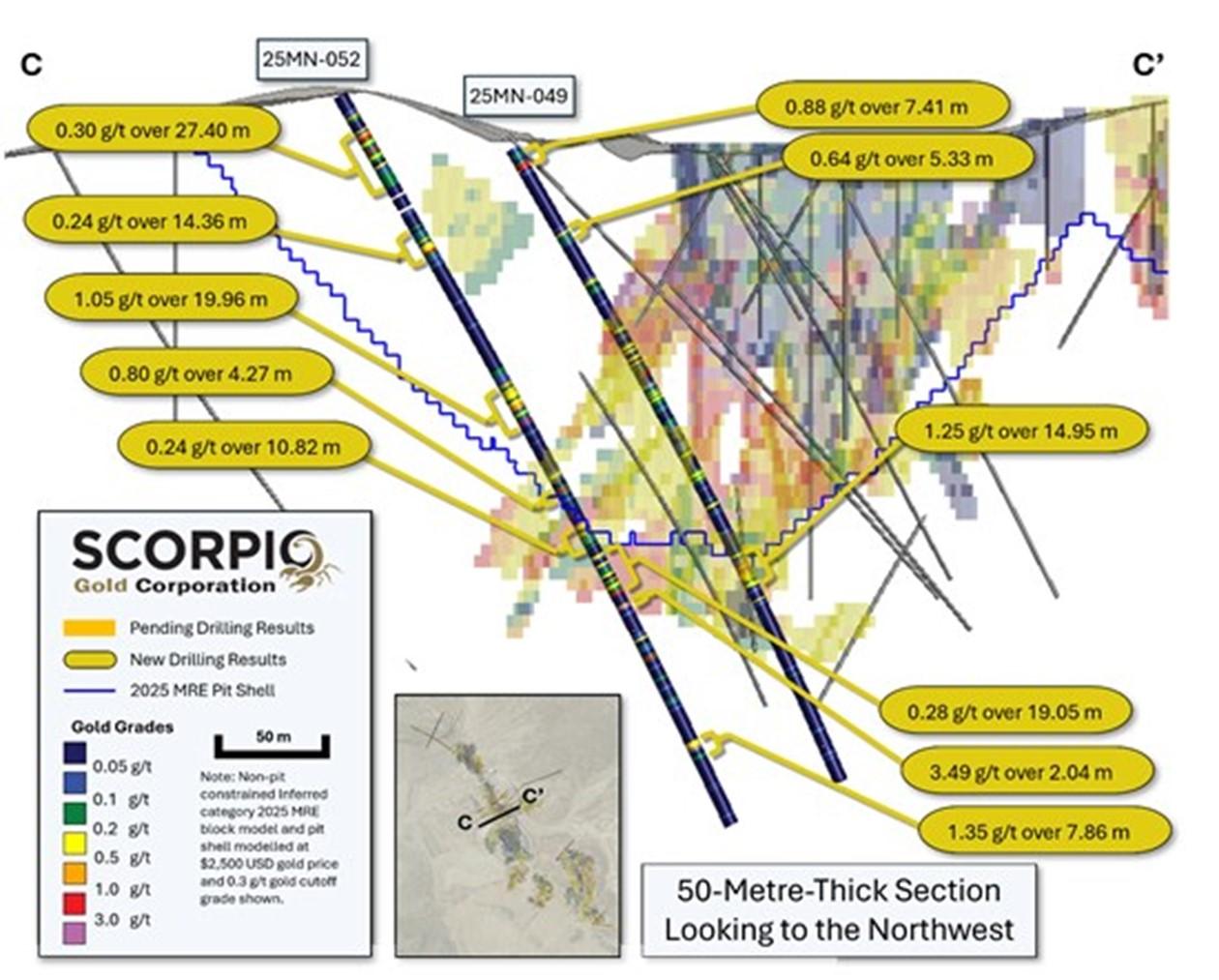
Figure 7. Cross-section C-C’, showing gold grades with reported intervals highlighted.
26MN-052: contains eight intervals hosted in the Cambrian Gold Hill Formation along the Reliance Trend to the north of the West Pit. These intervals are hosted in fine grained meta-sedimentary clastic and carbonate units, including 0.3 g/t gold over 27.4 m from 17.71 m; 0.24 g/t gold over 14.36 m from 64.71 m; 1.05 g/t gold over 19.96 m from 141.43 m (see Figure 8); 0.8 g/t gold over 4.27 m from 190.74 m; 0.24 g/t gold over 10.82 m from 208.85 m; 0.28 g/t gold over 19.05 m from 223.78 m; 3.49 g/t gold over 2.04 m from 247.59 m; 1.35 g/t gold over 7.86 m from 312.58 m. See Figure 7, section C to C’.
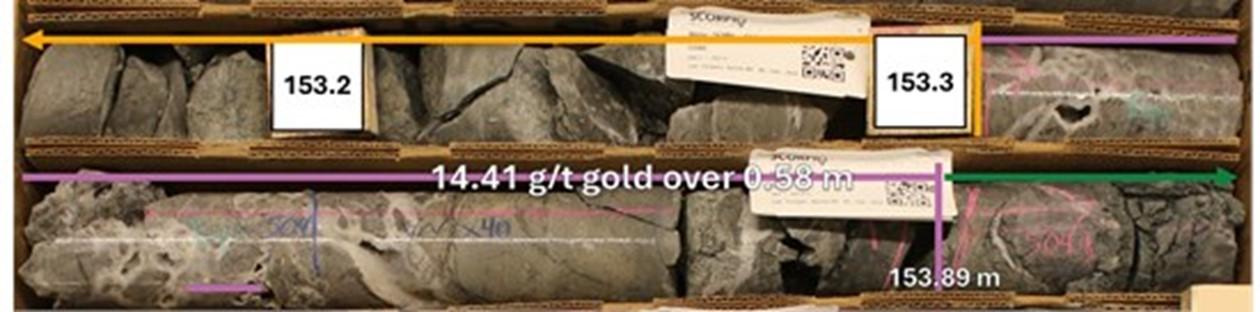
Figure 8. Drill hole 26MN-052, highlighting interval 153.3 to 153.9 m, displaying Cambrian Gold Hill Formation fine grained meta-sediments with high-grade quartz-calcite-adularia-fluorite epithermal veins.
East Pit Results:
26MN-051: This drill hole tested a northerly extension of a mineralised fault splay to the north of the East Pit, as a 50 m step-out to the southeast from drill hole 26MN-046, see news release dated February 11, 2026. The drill hole contains two intervals in the Cambrian Gold Hill Formation. The intervals are hosted in fine grained meta-sedimentary clastic units and include 0.23 g/t gold over 6.98 m from 118.29 m and 0.25 g/t gold over 6.55 m from 159.72 m.
26MN-054: This drill hole tested a northerly extension of a mineralised fault splay to the north of the East Pit, as a 50 m step-out to the northeast from drill hole 26MN-046. The drill hole contains one interval in the Cambrian Gold Hill Formation. The interval is hosted in fine grained meta-sedimentary clastic units and includes 0.4 g/t gold over 8.76 m from 257.89 m.
Sloppy Gulch Results:
26MN-050: This exploration drill hole tested a structure noted on a magnetic survey, a 1 km diameter circular gold in soils anomaly, in an area to the northeast of Mustang Hill with multiple historic adits. The drill hole did not produce any significant results.
QA/QC
HQ sized diamond drill core samples were cut in halves, then bagged and secured with security tags to ensure integrity during transportation to the Reno, NV, Paragon Geochemical facility for preparation. For quality assurance, unmarked coarse blanks, unmarked certified reference materials, and requested laboratory duplicates were inserted into the sampling sequence. QA samples were systematically inserted into each batch of samples, amounting to approximately 10% of the run of samples. Samples were analyzed for gold using method PA-AU02 (~500 g), a two-cycle PhotonAssayTM analysis of crushed material (70% passing 2 mm). All Paragon Geochemical facilities comply with ISO 17025:2017.
About the Manhattan District
Manhattan, located in the Walker Lane Trend of Nevada, USA, is road accessible and lies approximately 20 kilometers south of the operating Round Mountain Gold Mine (https://www.kinross.com/operations/default.aspx#americas-roundmountain), which has produced more than 15 million ounces of gold. For the first time, the Company has consolidated Manhattan’s past-producing mines under a single entity that holds valuable permitting and water rights. Historically, Manhattan has produced approximately 700,000 ounces of gold from high-grade placer and lode operations dating from the late 1890s through to the mid-2000s.¹ The maiden mineral resource estimate (the “Maiden MRE“) covering the Goldwedge and Manhattan Pit areas of Manhattan is comprised of 18,343,000 tonnes grading 1.26 g/t gold for a total of 740,000 oz contained gold in the inferred category.²
A historical mineral resource estimate covers the Black Mammoth, April Fool, Hooligan, Keystone, and Jumbo areas of Manhattan and comprises 1,652,325 tonnes grading 5.89 g/t gold for a total of 303,949 oz contained gold.³ The deposit is interpreted as a low-sulfidation, epithermal, gold-rich system situated adjacent to the Tertiary-aged Manhattan caldera in the Southern Toquima Range of Nevada. A “Qualified Person” as defined in National Instrument 43-101 – Standards of Disclosure for Mineral Projects has not done sufficient work to make the Historical MRE current, and the Company is not treating the Historical MRE as current.
Notes
The Company considers the Historical MRE relevant as it demonstrates the presence of significant gold mineralization across multiple zones within Manhattan; however, its reliability is uncertain because it was prepared prior to the adoption of the current CIM Definition Standards and current QA/QC practices. The Historical MRE provides limited disclosure of assumptions, parameters, estimation methods, cutoff grades, and QA/QC protocols, and therefore these cannot be fully verified by the Company. The categories used in the historical estimate predate, and are not directly comparable to, current CIM Definition Standards, and the Company is not treating the Historical MRE as a current Mineral Resource Estimate. To upgrade and verify the Historical MRE in order to make it a current Mineral Resource Estimate, the Company would be required to undertake confirmatory drilling, modern QA/QC sampling, validation and digitization of historical datasets and updated geological modeling followed by the preparation of a new Mineral Resource Estimate in accordance with CIM Definition Standards and NI 43-101. The Company encourages readers to exercise appropriate caution when evaluating the Historical MRE.
All scientific and technical information relating to Manhattan pertaining to the Historical MRE contained in this news release is derived from the Technical Report dated May 1997 titled “Exploration and Pre-Production Mine Development, Manhattan District Project, Nye County” prepared by New Concept Mining, Inc. The information contained herein in respect of the Historical MRE is subject to all the assumptions, qualifications and procedures set out in the Historical Technical Report and reference should be made to the full text of the Historical Technical Report.
Qualified Person
The scientific and technical information in this news release has been reviewed, verified and approved by Thomas Poitras, P. Geo., Chief Geologist of Scorpio Gold, a “Qualified Person”, as defined under National Instrument 43-101 Standards of Disclosure for Mineral Projects. Verification included review of laboratory certificates, review of field logs and chain-of-custody records, inspection of blank/standard/duplicate performance, and review of collar and down-hole survey data. No limitations or failures to verify were identified.
About Scorpio Gold Corp.
Scorpio Gold holds a 100% interest in the Manhattan District located in the Walker Lane Trend of Nevada, USA. Scorpio Gold’s Manhattan District is ~4,780-hectares and comprises the advanced exploration-stage Goldwedge Mine, with a 400 ton per day maximum capacity gravity mill, and four past-producing pits that were acquired from Kinross in 2021 (see news release dated March 25, 2021 https://scorpiogold.com/news/scorpio-gold-closes-purchase-of-kinross-manhattan-property-nye-county-nevada/). The consolidated Manhattan District presents an exciting late-stage exploration opportunity, with over 140,000 metres of historical drilling, significant resource potential, and valuable permitting and water rights.
VIOR GOLD CORPORATION INC. (TSX-V: VIO) (OTCQB: VIORF) (FRA: VL5)... READ MORE
Gravity-Finish Re-Assay Confirms High-Grade Gold Mineralization a... READ MORE
American Pacific Mining Corp. (CSE: USGD) (OTCQX: USGDF) (... READ MORE
Saw-cut sampling returned 20.2 g/t gold over 5.0 meters at surfac... READ MORE
McEwen Inc. (NYSE:MUX) (TSX: MUX) announced its first quarter fin... READ MORE


