


1911 Gold Corporation (TSX-V: AUMB) (OTCQX: AUMBF) is pleased to report assay results from the Company’s maiden exploration drilling program at the Wallace Project on the 100%-owned Rice Lake Property in southeast Manitoba.
Highlights:
The Company’s first pass drilling program at Wallace (Figure 1) was designed to test high-grade quartz veins within five different structures in the core of a regional scale fold, in rocks equivalent to the prolific Balmer assemblage in the Red Lake camp in adjacent Ontario.
The exploration model at Wallace is based on the Red Lake gold deposit in Ontario, which is hosted by age-equivalent rocks in a comparable geological and structural setting, located 100 kilometres east of the Rice Lake Property. Encouraging gold values obtained from all but one of the 2022 drillholes are associated with moderate to strong alteration (silica-biotite/sericite-pyrite) in well-developed shear structures cutting strongly-deformed sedimentary rocks intruded by granodiorite, quartz-feldspar porphyry, gabbro, and ultramafic or lamprophyric dikes.
2022 Exploration Drilling
The Crown-10 Target consists of a north-south shear structure up to 5 metres in width that is exposed for approximately 200 metres along strike. The structure cuts gabbro and granodiorite, and is intruded by ultramafic or lamprophyric dikes, indicating it is a deep-seated structure and a potentially significant fluid conduit. Channel samples returned assays up 26.4 g/t gold over 0.6 metres and 5.2 g/t gold over 2.0 metres, including 8.5 g/t gold over 1.2 metres. Three drillholes, totaling 861 metres and spaced roughly 60 metres apart, tested the structure beneath surface gold showings to a vertical depth of approximately 150 metres. The northern-most drillhole, CR-22-003, returned the most significant intercept: 2.9 g/t gold over 4.3 metres, including 10.1 g/t gold over 1.0 metres.
The Hi-Grade Target is a poorly-exposed structure traced for over 600 metres along strike in widely-spaced bedrock exposures that consistently returned gold values, including high-grade values up to 265.1 g/t gold from grab samples of shear-hosted quartz veins, and channel sample assays up to 5.6 g/t gold over 1.9 metres, including 9.0 g/t gold over 1.1 metres. Samples of black spruce bark collected in overburden-covered areas between gold showings yielded on-trend gold anomalies, suggesting continuity of the zone.
Two drillholes, totalling 562 meters, were completed to test the main surface showing and the unexposed potential extension indicated by the black spruce bark gold anomaly in an adjacent overburden-covered area, with the latter target yielding the most significant results. Drillhole HG-22-002 intersected two shear-hosted quartz veins, from 156.4 to 159.2 metres and from 178.0 to 182.6 metres downhole, with the upper vein returning 1.8 g/t gold over 2.1 metres, including 6.7 g/t gold over 0.6 metres from an interval containing numerous specks of visible gold. The presence of stacked quartz veins with localized high-grade gold indicates the significant exploration potential of this previously untested structure.
| (1) Numbering reflects order in which drillholes were planned, rather than sequence of drilling |
| (2) Represents drillcore length; true widths are presently unknown |
| (3) Weighted-average composites; NSV, no significant values |
Four drillholes, totalling 1,105 metres, tested an array of subparallel structures in the western portion of the project area. Although poorly exposed, the structures contain localized high-grade gold and are intruded by ultramafic or lamprophyric dikes, indicating they are relatively deep-seated structures and thus potentially significant fluid conduits. The Willi Target returned the most significant intercept, yielding 0.8 g/t gold over 6.4 metres, associated with laminated quartz veins and disseminated pyrite in strongly sheared granodiorite, in the immediate hangingwall of a sheared interval containing several ultramafic dikes.
2022 Field Exploration Program
Field exploration is ongoing at Wallace to expand detailed mapping, further delineate the prospective structures identified to date, and also evaluate the potential for parallel structures and sites of large-scale dilation suitable to host significant vein systems. With the success in delineating gold-bearing structures through overburden-covered areas at the Hi-Grade target, surficial geochemistry grids are being expanded into similarly prospective ground.
The first-pass drilling in 2022 identified several targets that merit follow-up drilling, currently in planning for Q3-Q4 2022, and the Company anticipates that ongoing field exploration will identify compelling new targets in this highly prospective area.
QA-QC Protocols
Sample handling, preparation and analysis are monitored through the implementation of formal chain-of-custody procedures and quality assurance-quality control programs designed to follow industry best practices. Drillcore is logged and sampled in a secure facility located in Bissett, Manitoba. Drillcore samples for gold assay are cut in half using a diamond saw and are submitted to Activation Laboratories Ltd. (Actlabs) in Ancaster, Ontario, for preparation by crushing to 80% passing 2 millimetres, riffle splitting to obtain 250-gram aliquots, and pulverizing to 95% passing 106 microns. Pulps are analyzed by a 30-gram fire assay and AAS finish. For assays above 5 g/t Au, a cut of the original pulp is re-assayed with a gravimetric finish. Samples with visible gold are analyzed by metallic screen assay. In addition to Actlabs’ in-house QA-QC protocols, 1911 Gold inserts certified standards, non-certified blanks and field duplicates into the sample stream at regular intervals, such that QA-QC accounts for 10% of the total samples submitted. Results are routinely evaluated for accuracy, precision and contamination.
Qualified Person Statement
Technical information in this news release has been reviewed and approved by Dr. Scott Anderson, Ph.D., P.Geo., the Company’s Vice President, Exploration, and Qualified Person as defined by Canadian National Instrument 43-101 – Standards of Disclosure for Mineral Projects.
About 1911 Gold Corporation
1911 Gold is a junior explorer that holds a highly prospective, consolidated land package totalling more than 58,000 hectares within and adjacent to the Rice Lake greenstone belt in Manitoba, and also owns the True North mine and mill complex at Bissett, Manitoba, where it reprocesses historic tailings on a seasonal basis. 1911 Gold believes its land package is a prime exploration opportunity, with potential to develop a mining district centred on the True North complex. The Company also owns the Apex project near Snow Lake, Manitoba and the Tully and Denton-Keefer projects near Timmins, Ontario, and intends to focus on both organic growth opportunities and accretive acquisition opportunities in North America.
1911 Gold’s True North complex and exploration land package are located within the traditional territory of the Hollow Water First Nation, signatory to Treaty No. 5 (1875-76). 1911 Gold looks forward to maintaining open, co-operative and respectful communication with the Hollow Water First Nation, and all local stakeholders, in order to build mutually beneficial working relationships.
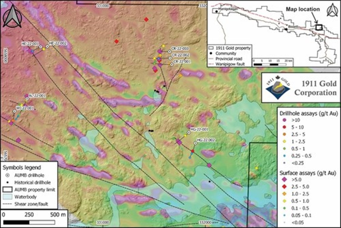
Figure 1: Location map of 2022 drillholes at Wallace (LiDAR base with UAV-MAG drape). (CNW Group/1911 Gold Corporation)
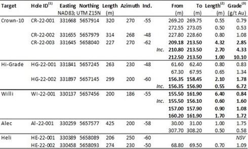
Table 1: Assay results from 2022 exploration drilling at the Wallace Project. (CNW Group/1911 Gold Corporation)
Sitka reports results for additional diamond drill holes; continu... READ MORE
Riverside Resources Inc. (TSX-V: RRI) (OTCQB: RVSDF) (FSE: 5YY0) ... READ MORE
Corcel Exploration Inc. (CSE: CRCL) (OTCQB: CRLEF) is pleased to ... READ MORE
Atlas Lithium Corporation (NASDAQ: ATLX) announced that it is on ... READ MORE
Drilling Continues to Demonstrate Mineral Resource Growth Potenti... READ MORE


