


![]()
1911 Gold Corporation (TSX-V: AUMB) (OTCQB: AUMBF) (FRA: 2KY) is pleased to announce new assay results from the surface drill program at the Company’s wholly-owned operational and fully permitted True North Gold Project, centrally located within the Company’s 100%-owned Rice Lake Gold property, southeast Manitoba, Canada. The latest assay results are from eight drill holes for 3,557 metres targeting the San Antonio Southeast target and the newly identified Shore target.
Drilling* Highlights:
* All drill results are quoted as downhole drill lengths.
“Our surface drill program at San Antonio Southeast and San Antonio West continues to demonstrate the size potential of these targets to add to the mineral resource base and potentially expand our future mining operations,” stated Shaun Heinrichs, President & CEO. “Developing new zones close to surface and current infrastructure provides potential operational efficiencies and expansion possibilities. We also see exciting potential at the new Shore target, our third new discovery, located south of San Antonio Southeast, which we plan to test further in the ongoing exploration drill program. We are very encouraged by the exploration drill results received to date and look forward to advancing our underground drill program using our existing infrastructure and access.”
1911 Gold has now completed seventy surface drill holes, for a total of 18,501.4 m of drilling. The surface exploration drill program within the True North mine footprint is focused on new targets defined by favourable host rocks and mineralized structural settings, also supported by significant historical drill intercepts. The most recent phase of the program consisted of two drill rigs targeting the down-dip extensions of mineralization at the SAM SE and San Antonio West (“SAM W”) targets, as well as testing the emerging Shore target. The surface drilling program was completed on September 20, 2025, and the project activities have now shifted to underground exploration, resource expansion and resource delineation drilling. Underground drilling commenced on October 1, 2025, with one drill rig on Level 16 (695 m below surface) within the True North gold mine. Mobilization of a second underground drill rig is planned for the second half of October.
*Along the L10 shear projected to vertical, San Antonio underground drifts and shafts projected up to 500 m from the north-west
**For drill results see press release dated August 7, 2025 (1911 Gold Intersects 5.52 g/t Au over 6.50 m and 54.00 g/t Au over 0.50 m on SAM Southeast Zone at True North).
***For drill results see press release dated April 1, 2025 (1911 Gold intersects up to 14.97 g/t Gold over 2.70 m, including 71.60 g/t Au over 0.50 m on SAM Southeast Zone at True North).
| Table 1: Select Significant Drill Hole Assay Results | |||||
| Target Area
(name) |
Drill Hole
(number) |
From
(m) |
To
(m) |
Interval
(m) |
Au
(g/t) |
| SAM Southeast | TN-25-062 | 333.00 | 333.50 | 0.50 | 7.05 |
| 343.20 | 343.70 | 0.50 | 6.21 | ||
| 353.30 | 353.80 | 0.50 | 3.41 | ||
| 356.00 | 359.20 | 3.20 | 7.03 | ||
| Including | 356.50 | 357.00 | 0.50 | 20.10 | |
| and | 358.70 | 359.20 | 0.50 | 18.60 | |
| 366.50 | 367.60 | 1.10 | 7.38 | ||
| Including | 367.00 | 367.60 | 0.60 | 11.40 | |
| SAM Southeast | TN-25-063 | 373.20 | 374.60 | 1.40 | 19.40 |
| 436.00 | 437.00 | 1.00 | 5.46 | ||
| 441.90 | 443.10 | 1.20 | 4.37 | ||
| 448.40 | 449.00 | 0.60 | 6.74 | ||
| SAM Southeast | TN-25-065 | 443.40 | 443.90 | 0.50 | 28.60 |
| 472.00 | 474.40 | 2.40 | 12.69 | ||
| Including | 472.00 | 472.70 | 0.70 | 15.20 | |
| 472.70 | 473.40 | 0.70 | 24.90 | ||
| Shore | TN-25-070 | 503.40 | 504.20 | 0.80 | 33.80 |
1) Intercepts above a cut-off grade of 2.25 g/t Au
2) Maximum of 2.50 m internal dilution and no top capping applied
3) Intervals represent drill core length and are considered to represent 60% to 90% of true widths
4) Intercepts reported at downhole depth
5) Full Significant Assay Results included in Table 2
6) Drill hole Information included in Table 3
San Antonio Southeast Target: Discussion of Results
Drilling completed to date has confirmed the extensions of gold mineralization within the SAM gabbro to over 500 m southeast of the historically mined San Antonio zone, covering an area 400 m long and over 740 m to depth. Thirty-four (34) holes, for a total of 8,813.4 m, have been drilled on the SAM SE target area as part of the current program. The results of six (6) drill holes for 2,347.0 m are included in this press release, of which two (2) drill holes, TN-25-065A (26.0 m) and TN-25-068 (390.0 m), did not reach target depths and were abandoned due to hole deviation.
The exploration drilling on the SAM SE target confirmed the presence of a vein system parallel to the historical San Antonio ore body, which shares the same geological, alteration, and mineralization characteristics. The mineralized intercepts are characterized by quartz-carbonate shear veins and vein breccias with sericite, chlorite alteration and pyrite disseminated and in veinlets developed in association with northeast and northwest trending shear zone corridors.
Drill hole TN-25-062, (7.05 g/t Au over 0.50 m; 6.21 g/t Au over 0.50 m; 7.03 g/t Au over 3.20 m, including 20.10 g/t Au over 0.50 m and 18.60 g/t Au over 0.50 m; and 7.38 g/t Au over 1.10 m, including 11.40 g/t Au over 0.60 m) was drilled to test the extensions of mineralization to the west of drill hole TN-25-054 (13.90 g/t Au over 0.50 m, see press release dated August 7, 2025 entitled: 1911 Gold Intersects 5.52 g/t Au over 6.50 m and 54.00 g/t Au over 0.50 m on SAM Southeast Zone at True North. The hole intersected high-grade mineralization within a wider zone approximately 30 m to the west of TN-25-054.
Drill hole TN-25-063 (19.40 g/t Au over 1.40 m; 5.46 g/t Au over 1.00 m; 4.37 g/t Au over 1.20 m and 6.74 g/t Au over 0.60 m), extended the high-grade gold mineralization 90 m to the west and 50 m down dip of drill hole TN-25-062.
Drill hole TN-25-065 confirmed the down plunge extensions (over 740 m) of gold mineralization from surface, intersecting 28.60 g/t Au over 0.50 m; 12.69 g/t Au over 2.40 m, including 15.20 g/t Au over 0.7 m and 24.90 g/t Au over 0.70 m, and extended the gold mineralization from drill hole TN-25-054 (13.90 g/t Au over 0.50 m)1, approximately 120 m deeper.
*Along the 007 shear zone projected to vertical, San Antonio drifts and shafts projected up to 900 m from the north-west
**For TN-25-019 drill results see press release dated April 1, 2025 (1911 Gold intersects up to 14.97 g/t Gold over 2.70 m, including 71.60 g/t Au over 0.50 m on SAM Southeast Zone at True North).
***For other drill results refer see Technical Report dated December 23, 2024 entitled “NI 43-101 Technical Report on the True North Gold Project, Bissett, Manitoba, Canada”
Shore Target: Discussion of Results
The newly identified Shore target is hosted within the same San Antonio gabbro unit and the intersection of the 007 shear, which is located approximately 500 m southeast of L10 shear zone (SAM SE). Three (3) holes for a total of 1,533 m have been drilled on the Shore target area as part of the current program (including drill hole TN-25-019, which intersected 13.20 g/t Au over 0.50 m at a downhole depth of 253.0 m)². The results of two (2) drill holes for 1,210 m are included in this press release, which were drilled to test the size potential of gold mineralization in drill step-outs from historical drill holes AB-07-003 (45.26 g/t Au over 0.61 m) and AB-10-001 (5.34 g/t Au over 2.41 m) all within the Shore target area (see Technical Report dated December 23, 2024 entitled “NI 43-101 Technical Report on the True North Gold Project, Bissett, Manitoba, Canada“).
Drill hole TN-25-070, intersected high-grade gold mineralization at a downhole depth of 503.40 m (33.80 g/t Au over 0.80 m), confirming the potential of this target for further drill testing.
Drill hole TN-25-069 intersected 6.05 g/t Au over 1.50 m at a downhole depth of 219.00 m within the L-10 zone hosted in the Shoreline Basalt.
1 – See press release dated August 7, 2025 (1911 Gold Intersects 5.52 g/t Au over 6.50 m and 54.00 g/t Au over 0.50 m on SAM Southeast Zone at True North).
2 – See press release dated April 1, 2025 (1911 Gold intersects up to 14.97 g/t Gold over 2.70 m, including 71.60 g/t Au over 0.50 m on SAM Southeast Zone at True North).
*Along the plunge of the SAM gabbro unit projected on a vertical plan with major shear traces, San Antonio underground workings, L24 and Deep East resource block model outlines, and contoured metal factors for drill pierce points.
San Antonio Southeast Target
The San Antonio Southeast target is located approximately 500 m southeast of the historically mined San Antonio zone of the True North Gold mine. The San Antonio Southeast target occurs within the gabbro of the San Antonio mafic unit and the intersection with the L-10 shear zone (Figure 1). The SAM gabbro hosts the majority of the known gold mineralization within the True North mine and historically produced 1,309,351 ounces Au at an average grade of 9.33 g/t Au (see Figure 5).
Shore Target
The emerging Shore target has been identified through geological modeling, historical drilling and confirmed with one previous exploration hole in 2025 (Drill hole TN-25-019 intersected 13.20 g/t Au over 0.50 m at a downhole depth of 253.00 m, see press release dated April 1, 2025, entitled: “1911 Gold intersects up to 14.97 g/t Gold over 2.70 m including 71.60 g/t Au over 0.50 m on SAM Southeast Zone at True North”). The Shore target is located to the southeast of SAM SE within the SAM gabbro on the intersection with the 007 shear zone corridor (Figure 1). The 007 shear hosts the historically mined 007 deposit hosted within the Shoreline Basalt located to the east. The modelled target zone is open at depth. Drilling from surface is limited due to the location of the upper section of the target area under Rice Lake.
Geological mapping is planned in the next few months to collect lithological and structural data from the accessible underground mine levels, which coupled with the drill hole logging data, will support the assessment and refinement of the geological interpretation and model.
| Table 2: True North; Significant Drill Hole Assays | ||||||
| Target Area
(name) |
Drill Hole
(number) |
From (m) |
To (m) |
Interval
(m) |
Au*
(g/t) |
|
| SAM Southeast | TN-25-062 | 332.00 | 332.50 | 0.50 | 1.59 | |
| 333.00 | 333.50 | 0.50 | 7.05 | |||
| 343.20 | 343.70 | 0.50 | 6.21 | |||
| 343.70 | 346.20 | 2.50 | 1.02 | |||
| 353.30 | 353.80 | 0.50 | 3.41 | |||
| 355.50 | 356.00 | 0.50 | 1.17 | |||
| 356.00 | 359.20 | 3.20 | 7.03 | |||
| Including | 356.50 | 357.00 | 0.50 | 20.10 | ||
| and | 358.70 | 359.20 | 0.50 | 18.60 | ||
| 365.00 | 366.50 | 1.50 | 0.57 | |||
| 366.50 | 367.60 | 1.10 | 7.38 | |||
| Including | 367.00 | 367.60 | 0.60 | 11.40 | ||
| SAM Southeast | TN-25-063 | 373.20 | 374.60 | 1.40 | 19.40 | |
| 426.10 | 427.00 | 0.90 | 0.62 | |||
| 436.00 | 437.00 | 1.00 | 5.46 | |||
| 440.00 | 441.00 | 1.00 | 0.70 | |||
| 441.90 | 443.10 | 1.20 | 4.37 | |||
| 447.00 | 448.40 | 1.40 | 1.05 | |||
| 448.40 | 449.00 | 0.60 | 6.74 | |||
| 452.10 | 456.00 | 3.90 | 0.95 | |||
| 467.00 | 468.00 | 1.00 | 0.56 | |||
| 469.80 | 470.30 | 0.50 | 0.58 | |||
| 472.50 | 474.00 | 1.50 | 1.41 | |||
| SAM Southeast | TN-25-065A | Abandoned at 26 m depth | ||||
| SAM Southeast | TN-25-065 | 421.20 | 422.00 | 0.80 | 1.51 | |
| 425.00 | 428.00 | 3.00 | 1.92 | |||
| 443.40 | 443.90 | 0.50 | 28.60 | |||
| 466.20 | 466.90 | 0.70 | 0.57 | |||
| 471.20 | 472.00 | 0.80 | 0.59 | |||
| 472.00 | 474.40 | 2.40 | 12.69 | |||
| Including | 472.00 | 472.70 | 0.70 | 15.20 | ||
| and | 472.70 | 473.40 | 0.70 | 24.90 | ||
| SAM Southeast | TN-25-066 | No Significant Values | ||||
| SAM Southeast | TN-25-068 | 375.50 | 375.80 | 0.50 | 0.73 | |
| 382.90 | 383.40 | 0.50 | 0.81 | |||
| 384.40 | 385.00 | 0.60 | 0.60 | |||
| 388.50 | 389.00 | 0.50 | 0.63 | |||
| Shore | TN-25-069 | 219.00 | 220.50 | 1.50 | 6.02 | |
| Shore | TN-25-070 | 4.50 | 5.70 | 1.20 | 0.55 | |
| 503.40 | 504.20 | 0.80 | 33.80 | |||
| 508.80 | 509.50 | 0.70 | 1.41 | |||
| 537.20 | 538.20 | 1.00 | 0.82 | |||
| 538.70 | 539.70 | 1.00 | 0.89 | |||
*Composites above 0.5 g/t Au and metal factor above 0.5 Au “gxm”
Next Steps
With the completion of the latest phase of surface drilling within the mine lease, the focus is now on mobilizing underground drill rigs to target areas within the True North gold mine footprint. Drilling will initially focus on areas accessible from Level 16 (695 m below surface), as this area is drill-ready and provides multiple favourable drill location options. The underground drill program is designed to continue extending the first two surface discoveries at depth as well as drill test the new exploration targets (see press release dated September 25, 2025, entitled “1911 Gold Commences Underground Drill Program at True North Gold Project”). The program will also focus on delineation drilling of two test mining targets that are accessible from Level 16, as well as target the extensions of the current resource, currently the focus of a Preliminary Economic Assessment study (“PEA”), including preliminary mine plan.
Rehabilitation work will commence in two areas over the coming months: the L13 deposit area accessed by ramp off the Hinge decline as well as Level 6, a previously unmapped area 262 m below surface, extending to the northwest from the A shaft of the San Antonio deposit underground workings. The L13 mine area will give the Company better access to drill the down-dip extensions of the SAM SE target. Level 6 will support the continuation of drilling into the SAM W target, as well as potentially drill testing the Cartwright Zone further west, an area containing a mineral resource inventory that remains open at depth.
Concurrently, the Company is permitting a 2,500 m drill program at Ogama-Rockland, which contains a near-surface, high-grade 43-101 mineral resource (November 15, 2013, entitled: “A Technical Review Of Ogama-Rockland Deposit on the Rice Lake Property, Manitoba, Canada.”, prepared by Watts, Griffis and McOuat,) and is located 35 kilometres by road southeast of the True North gold mine complex. The Company anticipates that the permits will be received in the coming weeks, allowing for this drill program to commence prior to the end of 2025.
| Table 3: True North; Drill Hole Details | ||||||||
| Drill Hole (Number) |
Target
(Name) |
Northing* (m) |
Easting* (m) |
Elevation (masl) |
Azimuth (°) |
Inclination (°) |
Depth (m) |
|
| TN-25-062 | SAM Southeast | 5655740 | 312669 | 259 | 154 | -76 | 371 | |
| TN-25-063 | SAM Southeast | 5655736 | 312672 | 259 | 0 | -90 | 536 | |
| TN-25-065 | SAM Southeast | 5655739 | 312672 | 259 | 112 | -79 | 575 | |
| TN-25-065A | SAM Southeast | 5655740 | 312671 | 262 | 114 | -79 | 26 | |
| TN-25-066 | SAM Southeast | 5655741 | 312672 | 259 | 210 | -72 | 449 | |
| TN-25-068 | SAM Southeast | 5655744 | 312674 | 259 | 324 | -81 | 390 | |
| TN-25-069 | Shore | 5655656 | 313214 | 275 | 243 | -67 | 605 | |
| TN-25-070 | Shore | 5655656 | 313214 | 275 | 237 | -55 | 605 | |
*Coordinates are provided in UTM NAD83 Zone 15
Deferred Share Units
The Company has issued 125,000 deferred share units to four directors under the LTIP in respect of Q3-2025 director fees. Each DSU entitles the holder to receive one share of the Company, or in certain circumstances a cash payment equal to the value of one share of the Company, at the time the holder ceases to be a director of the Company.
Qualified Person Statement
The scientific and technical information in this news release has been reviewed and approved by Mr. Michele Della Libera, P.Geo, Vice-President Exploration of 1911 Gold Corporation, who is a “Qualified Person” as defined under NI 43-101.
Quality Assurance/Quality Controls
Core samples are collected by sawing the drill core in half along the axis, with one-half sampled, placed in plastic sample bags, labelled, sealed, and the other half retained for future reference. Batches are shipped to Activation Laboratories Ltd. (Actlabs), in Thunder Bay, Ontario for sample preparation and analysis. Samples are dried, crushed to 2mm and a 1 kg split is pulverized to -200 mesh. Gold analysis is completed by fire-assay with an atomic absorption finish on 50 grams of prepared pulp. Samples returning values greater to 10.00 g/t are reanalysed by fire assay with a gravimetric finish. Total gold analysis (Screen Metallic Sieve) is conducted on highly mineralized samples or the presence of visible gold. Certified gold reference material samples are inserted every 20 samples and blank samples at intervals of one in every 50 samples, with additional blanks inserted after samples hosting visible gold. Repeat third-party gold analyses for 5% of all submitted sample pulps are analyzed at ALS-Chemex Laboratory, North Vancouver, Canada.
About 1911 Gold Corporation
1911 Gold is a junior explorer that holds a highly prospective, consolidated land package totaling more than 61,647 hectares within and adjacent to the Archean Rice Lake greenstone belt in Manitoba and also owns the True North gold mine and mill complex at Bissett, Manitoba. 1911 Gold believes its land package is a prime exploration opportunity, with the potential to develop a mining district centred on the True North complex. The Company also owns the Apex project near Snow Lake, Manitoba and the Denton-Keefer project near Timmins, Ontario, and intends to focus on organic growth and accretive acquisition opportunities in North America.
1911 Gold’s True North complex and exploration land package are located within the traditional territory of the Hollow Water First Nation, signatory to Treaty No. 5 (1875-76). 1911 Gold looks forward to maintaining open, co-operative and respectful communication with the Hollow Water First Nation and all local stakeholders to build mutually beneficial working relationships.
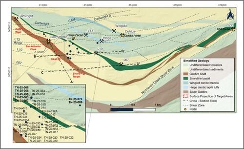
Figure 1: Plan View-True North-Geology and Targets with Drill Hole Locations (CNW Group/1911 Gold Corporation)
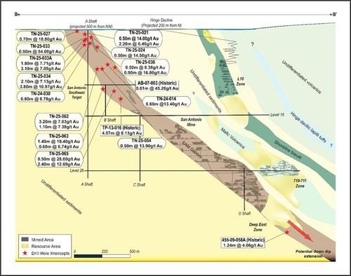
Figure 2: Cross Section (Looking North)-BB’ SAM SE (L10 Shear) (CNW Group/1911 Gold Corporation)
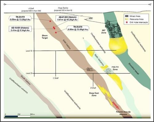
Figure 3: Cross Section (Looking North)-CC’ Shore Target (007 Shear) (CNW Group/1911 Gold Corporation)
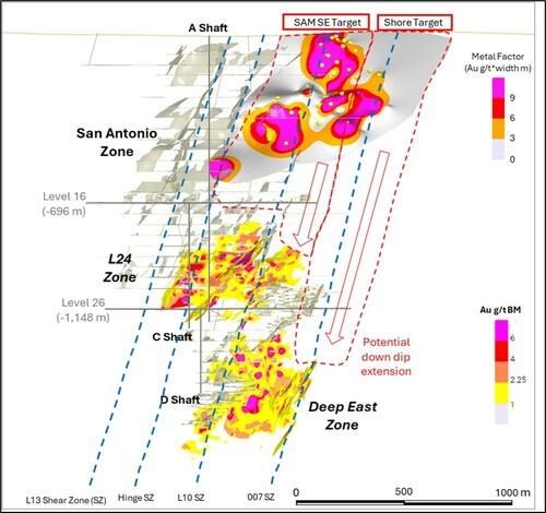
Figure 4: Long Section (Looking East)-AA’ SAM SE and Shore Targets (CNW Group/1911 Gold Corporation)
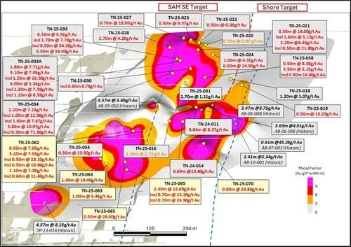
Figure 5: Long Section (Looking East)-Expanded view from AA’ of SAM SE and Shore Targets (CNW Group/1911 Gold Corporation)
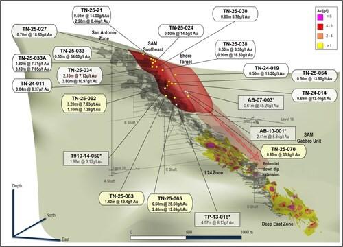
Figure 6: Isometric view (Looking NW)- SAM SE and Shore Targets within the SAM gabbro unit (CNW Group/1911 Gold Corporation)
Hudbay Minerals Inc. (TSX:HBM) (NYSE: HBM) today released its ann... READ MORE
Strategic acquisition of an established operating gold mine, loca... READ MORE
Cerro de Pasco Resources Inc. (TSX-V: CDPR) (OTCQB: GPPRF) (FRA: ... READ MORE
The Garneau Titanium Project Features Ilmenite-Rich Boulder with ... READ MORE
ValOre Metals Corp. (TSX‐V: VO) (OTCQB: KVLQF) (Frankfurt: KEQ0... READ MORE


